
Villeret BE
| BE is the abbreviation for the canton of Bern in Switzerland and is used to avoid confusion with other entries of the name Villeret . |
| Villeret | |
|---|---|
 |
|
| State : |
|
| Canton : |
|
| Administrative district : | Bernese Jura |
| BFS no. : | 0448 |
| Postal code : | 2613 |
| Coordinates : | 568 214 / 223280 |
| Height : | 740 m above sea level M. |
| Height range : | 723–1594 m above sea level M. |
| Area : | 16.24 km² |
| Residents: | 925 (December 31, 2018) |
| Population density : | 57 inhabitants per km² |
| Mayor : | Richard Habegger ( FDP ) |
| Website: | www.villeret.ch |
_026.JPG) Villeret photographed from the train |
|
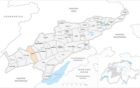
| Location of the municipality | |
  |
|
Villeret is a municipality in the Bernese Jura administrative district in the canton of Bern in Switzerland .
geography
Villeret is 740 m above sea level. M. , 17 km west of Biel (linear distance) and 1.5 km northeast of Saint-Imier . The village extends in the central part of the Vallon de Saint-Imier Jura Valley on both sides of the Schüss ( French Suze ), at the confluence of the Combe Grède creek.
The area of the 16.2 km² municipal area comprises a relatively narrow section of the valley basin of the Vallon de Saint-Imier. The 300 m wide valley of the Schüss takes up the central part. In the north, the area extends to the anticline of the Montagne du Droit (up to 1255 m above sea level ) and into the depression at Les Breuleux. To the south, Villeret extends to the height of the Chasseral chain, at 1590 m above sea level. M. only a little west of the Chasseral summit the highest point of the municipality is reached. At the top of the Chasseral chain, the hard cover rock was broken up and eroded away, creating a northern and a southern ridge over the course of millions of years. In between there is an anticline valley that has already been cleared to the next hard rock layer. The northern ridge, in the Cornette 1494 m above sea level. M. , is interrupted in the municipality of Villeret by a striking erosion valley , the Combe Grède . This is placed under nature protection. On the wide ridges of the Montagne du Droit and the Chasseral chain, there are extensive Jura high pastures with the typical, mighty spruce trees , either individually or in groups. The height of the Chasseral is already above the regional tree line. In 1997, 4% of the municipal area was in settlements, 51% in forests and woodland, 44% in agriculture and a little less than 1% was unproductive land.
Villeret has numerous individual farms that are widely scattered in the valley and on the Jura heights. Villeret's neighboring municipalities are Saint-Imier , Nods and Cormoret in the canton of Bern, Les Breuleux and Muriaux in the canton of Jura and Val-de-Ruz in the canton of Neuchâtel .
population
| Population development | |
|---|---|
| year | Residents |
| 1850 | 970 |
| 1900 | 1,422 |
| 1910 | 1,507 |
| 1930 | 1,253 |
| 1950 | 1,155 |
| 1960 | 1,125 |
| 1970 | 1,057 |
| 1980 | 884 |
| 1990 | 986 |
| 2000 | 901 |
With 925 inhabitants (as of December 31, 2018), Villeret is one of the medium-sized communities in the Bernese Jura . 83.1% of the residents are French-speaking, 11.3% German-speaking and 2.4% speak Albanian (as of 2000). After peaking in 1910, Villeret's population had decreased by almost 25% by 1950. A temporary stagnation phase was again replaced by a significant population decline during the economic crisis of the 1970s.
politics
The voting shares of the parties at the 2015 National Council election were: SP 29.0%, SVP 28.4%, FDP 12.0%, BDP 9.3%, GPS 8.1%, glp 4.0%, EPP 2.1 %, SD 1.7%, CVP 1.6%, EDU 1.5%.
economy
Until the first half of the 19th century, Villeret was mainly characterized by agriculture . As early as 1725, watchmaking began to develop in homework and in small workshops. In the middle of the 19th century a rapid economic boom began with the establishment of watch factories. Today there are still jobs in the watchmaking industry ( Cartier ), in the manufacture of precision tools and in local trade. Agriculture also still plays an important role, with livestock and dairy farming predominating, and there is some arable farming in the valley .
traffic
The community is very well developed in terms of transport. It is located on the busy main road from Biel to La Chaux-de-Fonds . On April 30, 1874, the railway line from Biel to Convers was opened with a train station in Villeret.
history

Villeret was first mentioned in writing in 1330. Until 1797 the village belonged to the Erguel lordship , which was subordinate to the Duchy of Basel , although the city of Biel also exerted greater influence at times and introduced the Reformation in 1530 . From 1797 to 1815 Villeret belonged to France and was initially part of the Mont-Terrible department , which was connected to the Haut-Rhin department in 1800 . As a result of the decision of the Congress of Vienna , the place came to the canton of Bern in the Courtelary district in 1815 .
Attractions
The reformed village church was built in 1935-1936. In the center there are both old farmhouses from the 18th century and buildings in the classicism style that were built during the boom of the watch industry. The school building dates from 1865. The modern architecture is represented by the Cartier company building designed by Jean Nouvel .
photos

View to the village center

Local government

reformed Church

Primary school building

Village center

Café Fédéral restaurant

Montblancs Institute de Recherche en Haute Horlogerie

ETA, watch industry

Villeret seen through the Combe Grède


Personalities
- Paul-Alcide Blancpain (1839–1899), brewery entrepreneur
Web links
- Official website of the municipality of Villeret (French)
- Christine Gagnebin-Diacon: Villeret. In: Historical Lexicon of Switzerland .
Individual evidence
- ↑ Permanent resident population from STAT-TAB of the BfS , municipalities see also regional portraits 2020 on bfs.admin.ch, accessed on May 29, 2020
- ^ Results of the municipality of Villeret. State Chancellery of the Canton of Bern, October 18, 2015, accessed on April 17, 2016 .
Belprahon | Champoz | Corcelles | Corgémont | Cormoret | Cortébert | Court | Courtelary | Crémines | Eschert | Grandval | La Ferrière | La Neuveville | Loveresse | Mont-Tramelan | Moutier | Nods | Orvin | Perrefitte | Péry-La Heutte | Petit-Val | Plateau de Diesse | Rebévelier | Reconvilier | Renan | Roches | Romont | Saicourt | Saint-Imier | Suction | Saules | Scolding (La Scheulte) | Seehof (Elay) | Sonceboz-Sombeval | Sonvilier | Sorvilier | Tavannes | Tramelan | Valbirse | Villeret
Former municipalities: Bévilard | Châtelat | This | La Heutte | Lamboing | Malleray | Monible | Péry | Plagne | Pontenet | Prêles | Sornetan | Souboz | Tramelan lingerie | Tramelan Dessus | Vauffelin
Canton of Bern | Administrative districts of the canton of Bern | Municipalities of the Canton of Bern