
Champoz
| Champoz | |
|---|---|
 |
|
| State : |
|
| Canton : |
|
| Administrative district : | Bernese Jura |
| BFS no. : | 0683 |
| Postal code : | 2735 |
| Coordinates : | 589 399 / 233.85 thousand |
| Height : | 849 m above sea level M. |
| Height range : | 679–1255 m above sea level M. |
| Area : | 7.17 km² |
| Residents: | 170 (December 31, 2018) |
| Population density : | 24 inhabitants per km² |
| Website: | www.champoz.ch |
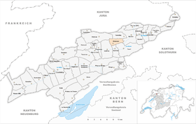
| Location of the municipality | |
  |
|
Champoz is a municipality in the Bernese Jura administrative district in the canton of Bern in Switzerland .
geography

Champoz is 849 m above sea level. M. , 6 km west-southwest of Moutier (linear distance). The farming village extends on the wide saddle between two Jura chains north of the long valley Vallée de Tavannes .
The area of the 7.1 km² municipal area includes the saddle of Champoz and the valley that gradually deepens to the northeast towards Moutier. In the east, the area extends to the crest of the Jura range of Mont Girod (up to 1037 m above sea level ) and to the western edge of the Klus von Court ( Gorges de Court in French ), a typical breakthrough valley of the Birs through the Graitery range . To the north, the municipality extends over the steep slope of the Forêt du Droit up to the ridge of the Moron, which sloping towards the east . Here is at 1250 m above sea level. M. the highest point of Champoz. Both the ridge of the Moron and the Mont Girod have typical high Jura meadows with large spruce trees standing individually or in groups . In 1997, 4% of the municipal area was in settlements, 50% in forests and woodlands, 45% in agriculture and a little less than 1% was unproductive land.
Several individual farms belong to Champoz. Neighboring municipalities to Champoz are Valbirse , Petit-Val , Perrefitte , Moutier , Court and Sorvilier .
population
With 170 inhabitants (as of December 31, 2018), Champoz is one of the small communities in the Bernese Jura . 90.7% of the residents are French-speaking and 9.3% German-speaking (as of 2000). The population of Champoz was 190 inhabitants in 1850, 191 inhabitants in 1900. After that, a downward trend was observed overall, before the population began to increase again from 1980 (116 inhabitants).
politics
The voting shares of the parties at the 2015 National Council election were: SVP 63.8%, EDU 9.8%, EPP 6.6%, SP 5.3%, BDP 4.2%, FDP 4.0%, GPS 1.6 %, Philipp Jutzi 1.3%, CVP 1.3%, pirates 1.1%, SD 1.0%, glp 0.0%.
economy
Champoz is still a strongly agricultural village with dairy farming , cattle breeding and some arable farming . Outside the primary sector there are only a few jobs in the village. Many workers are therefore commuters and work in the communities of the Vallée de Tavannes or in Moutier.
traffic
The community is located away from the major thoroughfares. The main access to Champoz is from Bévilard, which is on the main road from Delémont to Biel / Bienne , a narrow road also leads from Moutier up to the village. Champoz has no connection to public transport.
history
Champoz is on the site of a Roman observation post that controlled the road from Moutier to Tavannes. At that time the gorge of Court was not yet accessible. The first written mention of Champoz was in 1365 under the name Champo . The village belonged to the Moutier-Grandval provost until the end of the 18th century . During the Swabian War of 1499, the place was devastated by the troops of Emperor Maximilian I. From 1797 to 1815 Champoz belonged to France and was initially part of the Mont-Terrible department , which was linked to the Haut-Rhin department in 1800 . By decision of the Congress of Vienna , the village came to the Canton of Bern in the district of Moutier in 1815 .
Attractions
In Champoz there are still some typical old farmhouses with storage buildings from the 17th and 18th centuries. The building of the village school with a bell tower was built in the late classical style. Ecclesiastically, Champoz belongs to the parish of Bévilard.
Web links
- Official website of the municipality of Champz (French)
- François Wisard: Champoz. In: Historical Lexicon of Switzerland .
Individual evidence
- ↑ Permanent resident population from STAT-TAB of the BfS , municipalities see also regional portraits 2020 on bfs.admin.ch, accessed on May 29, 2020
- ↑ Results of the municipality of Champoz. State Chancellery of the Canton of Bern, October 18, 2015, accessed on April 19, 2016 .
Belprahon | Champoz | Corcelles | Corgémont | Cormoret | Cortébert | Court | Courtelary | Crémines | Eschert | Grandval | La Ferrière | La Neuveville | Loveresse | Mont-Tramelan | Moutier | Nods | Orvin | Perrefitte | Péry-La Heutte | Petit-Val | Plateau de Diesse | Rebévelier | Reconvilier | Renan | Roches | Romont | Saicourt | Saint-Imier | Suction | Saules | Scolding (La Scheulte) | Seehof (Elay) | Sonceboz-Sombeval | Sonvilier | Sorvilier | Tavannes | Tramelan | Valbirse | Villeret
Former municipalities: Bévilard | Châtelat | This | La Heutte | Lamboing | Malleray | Monible | Péry | Plagne | Pontenet | Prêles | Sornetan | Souboz | Tramelan lingerie | Tramelan Dessus | Vauffelin
Canton of Bern | Administrative districts of the canton of Bern | Municipalities of the Canton of Bern