
Belprahon
| Belprahon | |
|---|---|
 |
|
| State : |
|
| Canton : |
|
| Administrative district : | Bernese Jura |
| BFS no. : | 0681 |
| Postal code : | 2744 |
| Coordinates : | 597 521 / 237142 |
| Height : | 627 m above sea level M. |
| Height range : | 540–1265 m above sea level M. |
| Area : | 3.81 km² |
| Residents: | 294 (December 31, 2018) |
| Population density : | 77 inhabitants per km² |
| Website: | www.belprahon.ch |
 Belprahon |
|
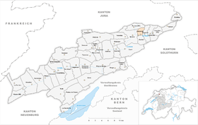
| Location of the municipality | |
  |
|
Belprahon is a municipality in the Bernese Jura administrative district in the canton of Bern in Switzerland . The former German name Tiefenbach is no longer used today.
geography
Belprahon is 627 m above sea level. M. , 2 km east-northeast of Moutier (linear distance). The farming village extends on the lower southern slope of Mont Raimeux , in the Juralängstal of Moutier, which is also called Grand Val .
The area of the 3.8 km² municipal area comprises a small section of the Grand Val. The southern border is formed by the La Raus stream , a right side stream of the Birs . From here the area stretches northward over the relatively gently rising slope of Belprahon and the subsequent wooded and rock-strewn steep slope of the Forêt du Droit to the high pastures Raimeux de Belprahon on the Mont-Raimeux chain. These mountain pastures with large spruce trees standing individually or in groups show the typical appearance of the Jura pastures. In the north, the valley of the Combe du Pont drains directly into the Birs gorge north of Moutier. The northern border runs on the Arête du Raimeux rock ridge . The highest point of Belprahon is 1265 m above sea level. M. on the top of the Raimeux chain west of the main summit. In 1997, 5% of the municipal area was accounted for by settlements, 54% for forests and woodland and 41% for agriculture.
Belprahon has several individual farms. Belprahon's neighboring municipalities are Moutier, Roches , Grandval and Eschert .
population
With 294 inhabitants (as of December 31, 2018) Belprahon is one of the small communities in the Bernese Jura . 88.1% of the residents are French-speaking, 6.4% German-speaking and 1.8% Italian-speaking (as of 2000). The population of Belprahon was 126 in 1850 and 188 in 1900. It has increased significantly since 1960 (133 inhabitants).
politics
The voting shares of the parties at the 2015 National Council election were: SVP 31.4%, SP 22.1%, CVP 12.3%, FDP 9.9%, PdA 7.0%, GPS 4.1%, BDP 3.6 %, Pirates 3.2%, glp 2.2%, EDU 1.9%, SD 1.1%, EVP 0.4%.
economy
Belprahon was a heavily agricultural village until the 1960s , but has since developed into a residential community. Outside the primary sector there are relatively few jobs in the village. Many workers (around 75%) are therefore commuters and work mainly in Moutier.
traffic
The community is located away from the major thoroughfares. It can be reached by a short spur road that branches off from the main road Moutier - Balsthal . The Mont Raimeux tunnel on the A16 motorway is currently being built, which will also cross under the municipality of Belprahon. This motorway was connected to both the Swiss national road network and the French motorway network in 2015 and has a junction east of Moutier, around 2 km from Belprahon. The village is connected to public transport by a bus line that runs between Moutier, Eschert and Belprahon.
history

The village name first appears in the documents in the 12th century. Until 1797 Belprahon was under the Moutier-Grandval Provost in the Principality of Basel. From 1797 to 1815 the place belonged to France and was initially part of the Mont-Terrible department , which was connected to the Haut-Rhin department in 1800 . By decision of the Congress of Vienna , Belprahon came to the Canton of Bern in the Moutier district in 1815 . Since 1967 the village has shared important infrastructures, such as the primary school and the sewage treatment plant, with the neighboring communities.
On September 17, 2017, there was a vote in Belprahon on whether the municipality should remain in the canton of Bern or move to the canton of Jura. With 121 (51.5%) to 114 votes (48.5%), those eligible to vote - unlike those of Moutier on June 18, 2017 - were extremely tight in favor of remaining in the canton of Bern. 237 of 242 eligible voters took part in the vote, which corresponds to a participation of 97.9%. Two voting complaints were filed. The small village can hardly be separated from the neighboring district capital Moutier , both ecclesiastically and administratively .
Attractions
The village school building with a bell tower was erected in 1872 in the style of late classicism . The old farmhouses from the 18th and 19th centuries, together with the warehouse buildings, shape a uniform townscape. New residential areas, including Les Amatennes , developed on the slope below the town center on both sides of the access road. Belprahon does not have its own church; it has belonged to the reformed parish of Moutier since 1531.
photos

Belprahon village school

Farmhouse

Restaurant Croix-Blanche (White Cross)

Village fountain


Web links
- Official website of the Belprahon Municipality
- François Wisard: Belprahon. In: Historical Lexicon of Switzerland .
Individual evidence
- ↑ Permanent resident population from STAT-TAB of the BfS , municipalities see also regional portraits 2020 on bfs.admin.ch, accessed on May 29, 2020
- ^ Results of the Belprahon Church. State Chancellery of the Canton of Bern, October 18, 2015, accessed on April 19, 2016 .
- ↑ Belprahon and Sorvilier remain with the Canton of Bern. In: Tages-Anzeiger . 19th September 2017.
- ↑ La commune de Belprahon (BE) ne rejoint pas Moutier dans le Jura. Radio Jura Bernois, September 17, 2017, accessed on September 29, 2017 (French).
Belprahon | Champoz | Corcelles | Corgémont | Cormoret | Cortébert | Court | Courtelary | Crémines | Eschert | Grandval | La Ferrière | La Neuveville | Loveresse | Mont-Tramelan | Moutier | Nods | Orvin | Perrefitte | Péry-La Heutte | Petit-Val | Plateau de Diesse | Rebévelier | Reconvilier | Renan | Roches | Romont | Saicourt | Saint-Imier | Suction | Saules | Scolding (La Scheulte) | Seehof (Elay) | Sonceboz-Sombeval | Sonvilier | Sorvilier | Tavannes | Tramelan | Valbirse | Villeret
Former municipalities: Bévilard | Châtelat | This | La Heutte | Lamboing | Malleray | Monible | Péry | Plagne | Pontenet | Prêles | Sornetan | Souboz | Tramelan lingerie | Tramelan Dessus | Vauffelin
Canton of Bern | Administrative districts of the canton of Bern | Municipalities of the Canton of Bern