
Mont-Tramelan
| Mont-Tramelan | |
|---|---|
 |
|
| State : |
|
| Canton : |
|
| Administrative district : | Bernese Jura |
| BFS no. : | 0437 |
| Postal code : | 2723 |
| Coordinates : | 570875 / 228980 |
| Height : | 1060 m above sea level M. |
| Height range : | 985–1203 m above sea level M. |
| Area : | 4.64 km² |
| Residents: | 122 (December 31, 2018) |
| Population density : | 26 inhabitants per km² |
| Website: | www.mont-tramelan.ch |
 Mont-Tramelan |
|
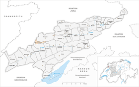
| Location of the municipality | |
  |
|
Mont-Tramelan (German Bergtramlingen ) is a predominantly German-speaking political municipality in the Bernese Jura administrative district of the Swiss canton of Bern .
geography

Mont-Tramelan is 1060 m above sea level. M. , 17 km northwest of Biel (air line), near Tramelan . The scattered settlement extends north of the Jura chain of the Montagne du Droit , on the edge of the plateau of the Franches-Montagnes (German Freiberge ).
The area of the 4.6 km² municipal area includes a section on the north flank of the anticline of the Montagne du Droit and the north adjoining height of the Freiberg mountains. In the far north the area extends to the edge of the La Tourbière peat bog . The highest point of Mont-Tramelan is 1200 m above sea level. M. on the northern slope of the Montagne du Droit. The community is located in the catchment area of the Trame , a left tributary of the Birs . A small exclave extends on the southern slope of the Montbautier ridge between Tramelan and Tavannes . In 1997, 4% of the municipal area was accounted for by settlements, 36% for forests and woodlands and 60% for agriculture.
The scattered settlement of Mont-Tramelan consists of numerous individual farms, including Les Vacheries Brunier at the pass from Tramelan to Les Breuleux . The neighboring communities of Mont-Tramelan are Courtelary , Cortébert , Corgémont , Tramelan , Tavannes and Saicourt in the canton of Bern and La Chaux-des-Breuleux in the canton of Jura .
population
population
With 122 inhabitants (as of December 31, 2018), Mont-Tramelan is one of the small communities in the Bernese Jura .
The population of Mont-Tramelan was 169 in 1850 and 149 in 1900. Since then, the population has always fluctuated between 115 and 150 people.
languages
70.7% of the residents speak German, 25.9% French and 2.6% speak Serbo-Croatian (as of 2000).
The fact that the community is predominantly German-speaking is due to the Mennonites who settled here on the Jura mountain ranges around 1570, such as on the Montagne du Droit (Sonnenberg) and the Montbautier (Stierenberg) with the permission of the Prince-Bishop of Basel .
According to a report by the Council of Europe, Mont-Tramelan is an officially French-speaking municipality with a German-speaking majority, while the Historical Lexicon of Switzerland writes that German was introduced as the official language in 1942, which led to tensions in the surrounding municipalities. This municipal decision was overturned by the government on June 19, 1942, but the municipal authority continues to use the German language when dealing with German speakers. In 1952 a decision was made in favor of the German language. Against the official use of German there have been protests from the French-speaking part of the Jura, especially against the German-speaking school, which has been public since 1897, and was previously private, the last time in 1980. Today, some subjects are taught in French; almost all students are bilingual.
politics
The voting shares of the parties in the 2015 National Council election were: SVP 48.3%, EPP 16.8%, BDP 15.2%, GPS 6.4%, SP 6.1%, FDP 2.6%, EDU 2.4 %, glp 2.0%, CVP 0.1%.
economy
Mont-Tramelan still lives from agriculture today , with cattle and horse breeding and dairy farming predominate. There are few jobs outside of the primary sector.
traffic
The municipality is located on the cantonal road from Tramelan to Le Noirmont . Mont-Tramelan is connected to the public transport network through a postbus course that runs from Tramelan to Saint-Imier .
history
The area of Mont-Tramelan was reclaimed at the beginning of the 17th century and settled by Anabaptists who had previously been expelled from the Emmental . Until 1797 the community was subordinate to the Principality of Basel . From 1797 to 1815, Mont-Tramelan belonged to France and was initially part of the Mont-Terrible department , which was linked to the Haut-Rhin department in 1800 . By the decision of the Congress of Vienna , the place came to the canton of Bern in 1815 , where it was assigned to the Courtelary district.
Attractions
Mont-Tramelan has some characteristic farmhouses of the Upper Jurassic from the 18th and 19th centuries.
Web links
- Christine Gagnebin-Deacon: Mont-Tramelan. In: Historical Lexicon of Switzerland .
Individual evidence
- ↑ Permanent resident population from STAT-TAB of the BfS , municipalities see also regional portraits 2020 on bfs.admin.ch, accessed on May 29, 2020
- ↑ a b Christine Gagnebin-Deacon: Mont-Tramelan. In: Historical Lexicon of Switzerland .
- ↑ [1] (PDF; 315 kB)
- ^ A b Chronique Jurassienne: Mont-Tramelan
- ↑ Chronique Jurasienne: Écoles allemandes
- ↑ Website Schule Mont-Tramelan (accessed on March 15, 2013)
- ^ Results of the municipality of Mont-Tramelan. State Chancellery of the Canton of Bern, October 18, 2015, accessed on April 17, 2016 .
Belprahon | Champoz | Corcelles | Corgémont | Cormoret | Cortébert | Court | Courtelary | Crémines | Eschert | Grandval | La Ferrière | La Neuveville | Loveresse | Mont-Tramelan | Moutier | Nods | Orvin | Perrefitte | Péry-La Heutte | Petit-Val | Plateau de Diesse | Rebévelier | Reconvilier | Renan | Roches | Romont | Saicourt | Saint-Imier | Suction | Saules | Scolding (La Scheulte) | Seehof (Elay) | Sonceboz-Sombeval | Sonvilier | Sorvilier | Tavannes | Tramelan | Valbirse | Villeret
Former municipalities: Bévilard | Châtelat | This | La Heutte | Lamboing | Malleray | Monible | Péry | Plagne | Pontenet | Prêles | Sornetan | Souboz | Tramelan lingerie | Tramelan Dessus | Vauffelin
Canton of Bern | Administrative districts of the canton of Bern | Municipalities of the Canton of Bern