
Tavannes
| Tavannes | |
|---|---|
 |
|
| State : |
|
| Canton : |
|
| Administrative district : | Bernese Jura |
| BFS no. : | 0713 |
| Postal code : | 2710 |
| UN / LOCODE : | CH TVS |
| Coordinates : | 582 032 / 230 017 |
| Height : | 754 m above sea level M. |
| Height range : | 739–1283 m above sea level M. |
| Area : | 14.78 km² |
| Residents: | 3586 (December 31, 2018) |
| Population density : | 243 inhabitants per km² |
| Mayor : | Fabien Vorpe ( FDP ) |
| Website: | www.tavannes.ch |
 Tavannes |
|
| Location of the municipality | |
  |
|
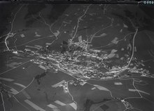
Tavannes is a municipality in the Bernese Jura administrative district in the canton of Bern in Switzerland . The German name Dachsfelden is rarely used today; it can still be found, for example, in the street name Dachsfelderstrasse in the city of Basel .
geography

Tavannes lies at 754 m above sea level. M. , 15 km southwest of the village of Moutier (air line) and 10 km north-northwest of Biel / Bienne . The industrial community extends on both sides of the river course of the Birs , on the southern edge of the broad basin of the Jura latitudinal valley Vallée de Tavannes and pass crossing at the foot of Pierre Pertuis .
The area of the 14.7 km² municipality covers a section of the western part of the Vallée de Tavannes, which here has a width of 4 km. The northern part of the area is covered by the hilly landscape between the lowlands of the Birs and the Trame , which is partially covered by the Forêt de Chaindon forest. The trough of Tavannes with the Birsquelle ( Source de la Birse ) forms the central part. To the south, the municipal area extends to the anticline that flanks the Vallée de Tavannes on its south side. In the area of Tavannes belong the westernmost section of the Montoz , with 1285 m above sea level. M. the highest point of the municipality, the pass cut by Pierre Pertuis and the easternmost part of the Montagne du Droit ( 1060 m above sea level ) with the height of La Tanne . On the Montagne du Droit there are extensive Jura high pastures with the typical mighty spruce trees , which either stand individually or in groups. In the far north-west the area extends over the valley of the Trame to the wooded southern slope of the Montbautier (up to 1040 m above sea level ). In 1997, 9% of the municipal area was accounted for by settlements, 42% for forests and woodlands and 49% for agriculture.
Tavannes has numerous individual farms that are widely scattered in the Tavannes basin and on the Jura heights. The neighboring municipalities of Tavannes are Saicourt , Reconvilier , Péry-La Heutte , Sonceboz-Sombeval , Corgémont , Tramelan and Mont-Tramelan .
population
| Population development | |
|---|---|
| year | Residents |
| 1850 | 672 |
| 1900 | 1,591 |
| 1910 | 2,655 |
| 1930 | 3,355 |
| 1950 | 3,650 |
| 1960 | 3,939 |
| 1970 | 3,869 |
| 1980 | 3,336 |
| 1990 | 3,188 |
| 2000 | 3,373 |
| 2010 | 3,478 |
With 3586 inhabitants (as of December 31, 2018) Tavannes is one of the largest communities in the Bernese Jura . 84.1% of the residents are French-speaking, 6.0% German-speaking and 3.6% Italian-speaking (as of 2000). The population of Tavannes increased significantly from 1850 to 1950. After the peak during the 1960s with around 4,000 inhabitants, a decline of 14% was recorded as a result of the economic crisis of the 1970s. Since then there have only been relatively minor fluctuations.
politics
The voting shares of the parties in the 2015 National Council election were: SVP 36.1%, SP 27.5%, BDP 7.3%, FDP 6.2%, EPP 5.6%, GPS 3.8%, EDU 3.6 %, glp 2.6%, PdA 2.3%, CVP 2.3%, SD 1.1%.
economy
Tavannes was an agricultural village until the middle of the 19th century , after which it quickly developed into an industrial community. Today around 7% of the workforce still work in agriculture, which mainly focuses on cattle breeding and dairy farming . Industrialization began around 1850 with the introduction of the watch industry from the Vallon de Saint-Imier (founding of the Tavannes Watch Co.). In the period that followed, the population rose significantly from 771 in 1870 to 3006 in 1920. The heyday of the watch industry led to a significant economic boom in the first half of the 20th century. Today watchmaking continues to play an important role, but there were also companies in the machine industry and precision mechanics. Another important employer is the company Tavapan SA. In addition to trading in wood-based materials, it manufactures high-quality sound absorption products in its own production.
traffic

The community has good transport links. It is located on the busy main road from Delémont to Biel / Bienne . Tavannes has been connected to the Swiss national road network since 1997 with the opening of the La Heutte-Tavannes section of the A16 motorway , which also includes the Pierre-Pertuis tunnel. The next section, the bypass of Tavannes and Reconvilier, has been under construction since 2008 and is due to open in 2012. The A16 is expected to connect Tavannes to the French motorway network by 2015.
The connection to the railway network took place on April 30, 1874 with the inauguration of the line from Sonceboz to Tavannes . On December 16, 1876, the continuation of the line from Tavannes to Court was opened. Eight years later, on August 16, 1884, the narrow-gauge line of the Tavannes – Tramelan Railway , a predecessor of the Chemins de fer du Jura , was added from Tavannes to Tramelan . A bus line runs from Tavannes via Bellelay and Lajoux to Les Genevez .
history
During Roman times , an important road connection led from Aventicum over the Pierre Pertuis pass through the Vallée de Tavannes to Augusta Raurica . At that time the pass was the border between the areas of the Helvetii in the south and the Rauriks in the north.
The reclamation and settlement of the Tavannes valley basin took place only after the Moutier-Grandval monastery was founded . The first written mention of Tavannes under the name Theisvenna goes back to the year 866. In the following period the spelling of the place name changed several times: Tehisvenna (884), Tasvenne (967), Tasuenna (1181) as well as Thasvanne , Taffennas and Tasueno . The etymology of the place name is controversial: Tavannes can either be traced back to the Celtic word tavan for tree trunk or to the Old High German dahs ( badger ) combined with the Germanic venjô ( pasture ), from which the German name Dachsfelden arose.
Tavannes belonged to the property of the Moutier-Grandval Abbey. After the foundation of the Bellelay monastery in the 12th century, the place was subordinated to this new monastery by the Prince-Bishop of Basel. At the same time, the von Tavannes family established themselves in a castle north of the town near Le Châtelet. The castle was destroyed in the Swabian War in 1499 and the noble von Tavannes family died out in the course of the 16th century. In 1530 Guillaume Farel introduced the Reformation in Tavannes .
From 1797 to 1815 Tavannes belonged to France and was initially part of the Mont-Terrible department , which was linked to the Haut-Rhin department in 1800 . By the decision of the Congress of Vienna , the place came to the canton of Bern to the district of Moutier in 1815 . A major citizen of Tavannes was Théophile Voirol , who became a general under Napoléon and served in North Africa.
Attractions

The current Reformed Church of Tavannes is a late Gothic building from 1385, which was restored several times and extended on the east side in 1728. The church stands on the site of the Saint-Etienne church mentioned in 866. The parsonage was built in 1820, the parish hall was furnished in the historicism style in 1927. Until 1928, all the surrounding villages (Reconvilier, Chaindon, Loveresse, Saules, Saicourt and Le Fuet) belonged to the parish of Tavannes. The Catholic Church Christi-Roi dates from 1928 to 1930.
In the town center, which has an urban character, there is the Hôtel de Ville (formerly Hôtel de la Couronne) in the late Classicism style (around 1850; renovated in 1966) and the Empire-style house of General Voirol. Numerous buildings date from the period from 1850 to 1920 and show architecture in neo-baroque and local style.
photos
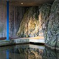
Contained source of the Birs

Mill

railway station
Roventa and Henex SA (watchmaking industry)

Catholic Church

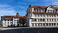
Primary school buildings

Secondary school house

Community hall


Personalities
- Théophile Voirol (1781–1848), general in French service
- Henri Frédéric Sandoz (1853–1913), watchmaker and entrepreneur
- Enrico Cobioni (1881–1912), aviation pioneer
- Paul Hänni (1914–1996), track and field athlete and Olympic participant
Web links
- Official website of the municipality of Tavannes (French)
- Christine Gagnebin-Deacon: Tavannes. In: Historical Lexicon of Switzerland .
Individual evidence
- ↑ Permanent resident population from STAT-TAB of the BfS , municipalities see also regional portraits 2020 on bfs.admin.ch, accessed on May 29, 2020
- ^ Results of the municipality of Tavannes. State Chancellery of the Canton of Bern, October 18, 2015, accessed on April 19, 2016 .
Belprahon | Champoz | Corcelles | Corgémont | Cormoret | Cortébert | Court | Courtelary | Crémines | Eschert | Grandval | La Ferrière | La Neuveville | Loveresse | Mont-Tramelan | Moutier | Nods | Orvin | Perrefitte | Péry-La Heutte | Petit-Val | Plateau de Diesse | Rebévelier | Reconvilier | Renan | Roches | Romont | Saicourt | Saint-Imier | Suction | Saules | Scolding (La Scheulte) | Seehof (Elay) | Sonceboz-Sombeval | Sonvilier | Sorvilier | Tavannes | Tramelan | Valbirse | Villeret
Former municipalities: Bévilard | Châtelat | This | La Heutte | Lamboing | Malleray | Monible | Péry | Plagne | Pontenet | Prêles | Sornetan | Souboz | Tramelan lingerie | Tramelan Dessus | Vauffelin
Canton of Bern | Administrative districts of the canton of Bern | Municipalities of the Canton of Bern