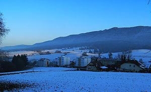
Montoz
| Montoz | ||
|---|---|---|
|
The Montoz with Tavannes |
||
| height | 1328 m above sea level M. | |
| location | Canton Bern | |
| Mountains | law | |
| Dominance | 5.06 km → Moron | |
| Notch height | 166 m ↓ La Bergerie | |
| Coordinates | 587557 / 229586 | |
|
|
||
The Montoz is a 1328 m above sea level. M. high ridge in the Swiss Jura . The highest peak, which bears the name La Rochette , lies on the ground in the Bernese municipality of Valbirse , around 6 km east of Tavannes .
geography
The ridge of the Montoz extends over a length of about 15 km in a west-east direction according to the general fold structure of the Jura in this region. On average it is around 3 km wide. The height of the Montoz is limited in the south by the longitudinal basin of Péry (flowed through by the Schüss , French: Suze , and its left side stream Terbez ), in the west by the cut of the Pierre Pertuis pass and in the north by the valley basin of the Vallée de Tavannes .
The limit towards the east is not clearly defined. The actual Montoz ends at the saddle of Hof Oberbürenberg (1170 m above sea level), but the eastern continuation up to the height of Grenchenberg is also assigned to the Montoz chain. Here the ridge rises up to a maximum of 1405 m above sea level. M. at. The height of the actual Montoz consists of an average 1250 m high ridge, which is crowned by several peaks that are 1300 m above sea level. Just exceed M.
The steep flanks of the Montoz are covered with thick beech and fir forests. On the mostly 0.5 to 1 km wide ridge area there are extensive Jura high pastures and several mountain farms. The pastureland is delimited by the characteristic dry stone walls. The sinkholes that occur in various places on the Montoz are also typical of the Jura ridges . The ridge is suitable for hiking; the more than 10 km long ridge hiking trail leads past several mountain restaurants.
geology
In structural geological terms, the Montoz forms an anticline of the Jura folds . The western continuation of this anticline is the Montagne du Droit , to the east it joins the southernmost Jura chain to form the Weissenstein anticline. The upcoming competent rock layers of the Upper Jurassic Period ( Malm ) are exposed in various places. The western part of the ridge in particular is subdivided by several erosion valleys sunk into the flanks .

