
Sonceboz-Sombeval
| Sonceboz-Sombeval | |
|---|---|
 |
|
| State : |
|
| Canton : |
|
| Administrative district : | Bernese Jura |
| BFS no. : | 0444 |
| Postal code : | 2605 |
| UN / LOCODE : | CH SZS |
| Coordinates : | 580 340 / 227397 |
| Height : | 653 m above sea level M. |
| Height range : | 619–1302 m above sea level M. |
| Area : | 14.96 km² |
| Residents: | 1968 (December 31, 2018) |
| Population density : | 132 inhabitants per km² |
| Mayor : | René Rimaz ( SVP ) |
| Website: | www.sonceboz.ch |
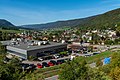
 View of Sonceboz |
|
| Location of the municipality | |
  |
|
Sonceboz-Sombeval is a municipality in the Bernese Jura administrative district in the canton of Bern in Switzerland .
geography
Sonceboz-Sombeval is 653 m above sea level. M. , 8 km northwest of Biel (air line). The double community extends on the eastern edge of the Jura Long Valley Vallon de Saint-Imier , on both sides of the Schüss ( French Suze ). Sonceboz is the southern pass point of the transition from Col de Pierre Pertuis to Tavannes , Sombeval is at the southern foot of the Montagne du Droit Jura chain .
The area of the 15.0 km² municipal area comprises the easternmost section of the wide valley basin of the Vallon de Saint-Imier. The central part is the up to 700 m wide valley of the Schüss. In the north the area extends to the anticline of the Montagne du Droit (up to 1060 m above sea level ), which is bounded in the east by the pass cut of the Pierre Pertuis. To the east of the pass, the municipal area includes the foothills of the Montoz chain (up to 1200 m above sea level ) and the Le Châtillon promontory , which forms the eastern end of the Vallon de Saint-Imier. The Châtillon moves closer to the Chasseral chain to the south and forces the Schüss into a narrow valley like a gorge. Sonceboz-Sombeval extends south to the height of the Chasseral chain. At the apex of this chain, the hard cover rock was broken up and eroded away, creating a northern and a southern ridge over the course of millions of years. In between there is an anticline valley that has already been cleared to the next hard rock layer. This vault forms a third ridge between the two outer ridges, the ridge of the Jobert , which at 1300 m above sea level. M. represents the highest elevation in the municipality. The southeastern border runs through a semicircle created by erosion . Part of the rock material removed forms an alluvial cone in the area of the Métairie de Nidau south of the Schüss. On the wide ridges of the Montagne du Droit and the Chasseral chain, there are extensive Jura high pastures with the typical, mighty spruce trees , either individually or in groups. In 1997, 8% of the municipal area was in settlements, 59% in forests and woodlands, 32% in agriculture and a little less than 1% was unproductive land.
Sonceboz-Sombeval has numerous individual farms that are widely scattered in the valley floor and on the Jura heights. Neighboring municipalities to Sonceboz-Sombeval are Corgémont , Orvin , Péry-La Heutte and Tavannes .
population
| Population development | |
|---|---|
| year | Residents |
| 1850 | 565 |
| 1900 | 1,158 |
| 1910 | 1,183 |
| 1930 | 1,224 |
| 1950 | 1'210 |
| 1960 | 1,404 |
| 1970 | 1,446 |
| 1980 | 1,332 |
| 1990 | 1'515 |
| 2000 | 1,666 |
| 2007 | 1,735 |
With a population of 1968 (as of December 31, 2018), Sonceboz-Sombeval is one of the larger communities in the Bernese Jura . 81.5% of the residents are French-speaking, 12.1% German-speaking and 3.2% Italian-speaking (as of 2000). The population of Sonceboz-Sombeval has increased significantly, especially in the second half of the 19th century and since 1980.
politics
The voting shares of the parties on the occasion of the 2015 National Council election were: SVP 37.0%, SP 21.1%, FDP 8.4%, BDP 7.7%, GPS 7.3%, EDU 7.1%, EVP 5.1 %, CVP 2.7%, PdA 1.2%, glp 1.1%.
economy
Sonceboz-Sombeval was mainly characterized by agriculture until the second half of the 19th century . After that, with the introduction of the watch industry, an economic upswing set in. Today there are jobs in the field of microtechnology, in the manufacture of precision tools and in local trade. Agriculture also plays an important role, with arable and fruit growing in the lower elevations, and cattle breeding and dairy farming on the Jura heights .
traffic

The municipality is located on the main road from Biel to La Chaux-de-Fonds , from which the pass road branches off in Sonceboz via the Pierre Pertuis. With the opening of the A16 motorway from La Heutte to Tavannes in 1997, the town was relieved of through traffic. On April 30, 1874, the railway lines from Biel to Convers and the line from Sonceboz-Sombeval to Tavannes were inaugurated, the latter leading in a large arc around the town. The Pierre-Pertuis-Pass is crossed by the motorway and the railway through 2.1 km and 1.3 km long tunnels respectively.
tourism
The 33-kilometer Anabaptist Trail (French: Chemin des Anabaptistes ) begins in Sonceboz-Sombeval . It was opened in June 2010 and recalls the story of the persecuted Anabaptists who found refuge and settled in the Principality of Basel in the 17th and 18th centuries .
history

An important road over the Pierre Pertuis led through the municipality of Sonceboz-Sombeval in Roman times . At that time there was probably a fort on the hilltop of Le Châtillon.
The first written mention of Sombeval came in 866 under the name Summavallis . The settlement, which at that time probably only consisted of a farm, already had a chapel and belonged to the Moutier-Grandval monastery . In 1148 a court was mentioned in Sumbavalle . Later names are Someval (1179), Sunbaval (1228) and Sombeaulx (1461).
Sonceboz is first mentioned as Suncebolz in 1303 . This was followed by the spellings Suntcelibsis (1405), Sunsebols (1461) and Suntzelbo . The place name is derived from the forest ( bois ) of a man named Suso .
In the 15th century a large part of the population was killed by the plague . Until 1797 the village belonged to the Erguel lordship , which was subordinate to the Duchy of Basel , although the city of Biel also exerted greater influence at times. From 1797 to 1815 Sonceboz-Sombeval belonged to France and was initially part of the Mont-Terrible department , which was linked to the Haut-Rhin department in 1800 . As a result of the decision of the Congress of Vienna , the place came to the canton of Bern in the Courtelary district in 1815 .
photos
View of the two parts of the village

railway station

Church in the Sombeval part of the village

Schoolhouse (old)

Schoolhouse (new) and municipal administration

Hotel-Restaurant "Du Cerf"

Sonceboz SA (industry)


Web links
- Official website of the municipality of Sonceboz-Sombeval (French)
- Anne Beuchat-Bessire and Catherine Krüttli: Sonceboz-Sombeval. In: Historical Lexicon of Switzerland .
Individual evidence
- ↑ Permanent resident population from STAT-TAB of the BfS , municipalities see also regional portraits 2020 on bfs.admin.ch, accessed on May 29, 2020
- ↑ Results of the Sonceboz-Sombeval municipality. State Chancellery of the Canton of Bern, October 18, 2015, accessed on April 17, 2016 .
Belprahon | Champoz | Corcelles | Corgémont | Cormoret | Cortébert | Court | Courtelary | Crémines | Eschert | Grandval | La Ferrière | La Neuveville | Loveresse | Mont-Tramelan | Moutier | Nods | Orvin | Perrefitte | Péry-La Heutte | Petit-Val | Plateau de Diesse | Rebévelier | Reconvilier | Renan | Roches | Romont | Saicourt | Saint-Imier | Suction | Saules | Scolding (La Scheulte) | Seehof (Elay) | Sonceboz-Sombeval | Sonvilier | Sorvilier | Tavannes | Tramelan | Valbirse | Villeret
Former municipalities: Bévilard | Châtelat | This | La Heutte | Lamboing | Malleray | Monible | Péry | Plagne | Pontenet | Prêles | Sornetan | Souboz | Tramelan lingerie | Tramelan Dessus | Vauffelin
Canton of Bern | Administrative districts of the canton of Bern | Municipalities of the Canton of Bern