
Chasseral
| Chasseral | ||
|---|---|---|
 Aerial view in winter |
||
| height | 1606.2 m above sea level M. | |
| location | Canton of Bern , Switzerland | |
| Mountains | law | |
| Dominance | 49.5 km → Pfyffe | |
| Notch height | 670 m ↓ Les Verrières | |
| Coordinates | 571 359 / 220 485 | |
|
||
| rock | limestone | |
| particularities | highest point in the Bernese Jura | |

The Chasseral is at 1606 m above sea level. M. the highest point in the Bernese Jura , in the northwest of the canton of Bern , Switzerland . Its former German name Gestler is still partially used in the region, but is not known in the rest of Switzerland.
80 meters east of the mountain top is the Nods Chasseral transmitter .
geography
The Chasseral is part of the Folded Jura . The approximately 20-kilometer Chasseral chain is in the north through the valley of Saint-Imier , on the east by the gorges of Suze ( French Suze ), the south by the Lake Biel and on the west by the de Val Ruz limited. On the southern slope of the Chasseral lies at 800 m above sea level. M. the extensive high plateau Tessenberg with several villages. The Combe Grède , a steep gorge that is now a nature reserve, stretches northwest to the Saint-Imier valley .
Climate table
| Chasseral, 1981-2010 | ||||||||||||||||||||||||||||||||||||||||||||||||
|---|---|---|---|---|---|---|---|---|---|---|---|---|---|---|---|---|---|---|---|---|---|---|---|---|---|---|---|---|---|---|---|---|---|---|---|---|---|---|---|---|---|---|---|---|---|---|---|---|
| Climate diagram | ||||||||||||||||||||||||||||||||||||||||||||||||
| ||||||||||||||||||||||||||||||||||||||||||||||||
|
Average monthly temperatures and rainfall for Chasseral, 1981-2010
Source:
|
||||||||||||||||||||||||||||||||||||||||||||||||||||||||||||||||||||||||||||||||||||||||||||||||||||||||||||||||||||||||||||||||||||||||||||||||||||||||||||||||||||||||||||||||||||
Flora and geology
The Chasseral is forested up to an altitude of 1400 m , above which there are mountain pastures. They are rich in alpine perennials , which provide colorful flowering aspects in summer. The yellow gentian, for example, grows in large numbers on the slopes . The rocks are overgrown with dwarf bluebells , among other things .
From the summit, numerous sinkholes can be seen that have formed in the fissured and karstified limestone.
There are several caves on the Chasseral, which fill with snow and ice over the winter and used to be used as cold storage for the food industry or for the extraction of cold ice. The best known of these is the Creux de Glace .
Economic use
On June 26, 1945, the first PTT transmission tower was put into operation. From 1954 the tower was used for radio and car phone operation. In 1970 a provisional broadcasting facility for television reception was added on the mountain range between Solothurn and Yverdon . Since 1983 the PTT and today Swisscom Broadcast have maintained a 120-meter-high transmitter mast on the Chasseral, mainly on behalf of SRG SSR . Today it is operated remotely and is 90 percent empty.
reachability
Both from Saint-Imier in the north and from Nods on the Montagne de Diesse, the height of the Chasseral can be reached in the summer by a road that crosses the mountain range at the Col du Chasseral . In summer there is also a bus line from both sides (between Nods and Chasseral only on weekends).
Until 1993, a chairlift led from Nods to the mountain inn to the west just below the Chasseral summit. In winter, skiing is possible on the western slope at Les Bugnenets and on the southern slope above Nods. A hiking trail with great views runs over the ridge and forms a section of the wide Jura mountain path . On a clear day, the Chasseral offers an alpine panorama that extends from Säntis to Mont Blanc .
photos

Summit of the Chasseral with mountain inn and transmission tower

Lake Biel with the Chasseral in the background
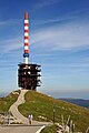
The transmitter mast on the Chasseral

Dolines on the Chasseral, in the background the Combe Grède gorge with the village of Villeret

The Combe Grède is the steepest, but also the shortest ascent to the Chasseral


Web links
- Chasseral Nature Park
- Chasseral on wanderland.ch
Individual evidence
- ↑ Climate table. In: meteoschweiz.admin.ch. meteoschweiz, accessed on June 1, 2018 .
- ↑ https://www.outdooractive.com/de/naturdenkmal/neuenburg-jura-berner-jura/creux-de-glace/7131066/
- ^ Hubert Droz: Visite de la SRT à l'antenne du Chasseral . In: Média-tic, le journal des sociétés de radiodiffusion et de télévision de la Suisse romande . No. 204 . RTSR, Lausanne December 2018, p. 10 .
- ↑ Closed down in 1993, the Nods-Chasseral chairlift is scheduled for the Expo. In: Bieler Tagblatt. July 26, 2000, accessed August 18, 2014 .