
Les Verrières
| Les Verrières | |
|---|---|
 |
|
| State : |
|
| Canton : |
|
| District : | No district division |
| BFS no. : | 6511 |
| Postal code : | 2126 |
| UN / LOCODE : | CH LVR |
| Coordinates : | 527 112 / 195385 |
| Height : | 930 m above sea level M. |
| Height range : | 910–1286 m above sea level M. |
| Area : | 28.87 km² |
| Residents: | 669 (December 31, 2018) |
| Population density : | 23 inhabitants per km² |
| Website: | www.lesverrieres.ch |
 Les Verrières |
|
| Location of the municipality | |
  |
|
Les Verrières is a municipality in the canton of Neuchâtel in Switzerland .
geography
Les Verrières is 930 m above sea level. M. , 36 km west-southwest of the canton capital Neuchâtel (linear distance). The street-line village extends in the high valley of Vallon des Verrières , surrounded by the heights of the western Neuchâtel Jura , near the border with France .
The area of the 28.7 km² municipal area includes the central section of the Vallon des Verrières, a syncline that is drained above ground through the Morte river to the west to the Doubs and thus to the Mediterranean . The watershed of the surface rivers at Les Verrières is not congruent with that of the seepage water. The water seeping into the ground runs along fracture systems to the east, belongs to the catchment area of the Areuse and flows with it in the direction of the Rhine to the North Sea .
To the south of the wide valley, the communal soil extends over the steep slope of La Côtière to the anticline of Mont des Verrières ( 1241 m above sea level ). To the north, the area extends over the forest heights of Les Cornées and the depression Loge de la Grande Planée (in the extreme southwest of the Vallée de la Brévine ) to the ridge of Chez le Brandt ( 1230 m above sea level ) and Les Divois (at 1290 m above sea level ) m above sea level, the highest point of Les Verrières), which is part of the Montagne du Larmont system . To the north of this ridge lies the valley of the Ruisseau des Entreportes , the water of which flows into the Doubs at Pontarlier . The northern border runs on the Les Passages forest crest (up to 1164 m above sea level ).
On the heights around Les Verrières there are extensive Jura high pastures with the typical mighty spruce trees , which either stand individually or in groups. In 1997, 3% of the municipal area was settled, 50% forest and woodland, 46% agriculture and a little less than 1% was unproductive land.
Les Verrières consists of the central town of Grand Bourgeau , the hamlets of Belle-Perche and Le Crêt to the east and the hamlets of La Croix-Blanche and Meudon to the west . Les Verrières also includes the hamlets of Mont des Verrières ( 1200 m above sea level ) on the mountain of the same name south of the valley, Petits Cernets ( 1142 m above sea level ) and Grands Cernets ( 1160 m above sea level ) on the southern slope of the Larmont chain and numerous individual farms are widely scattered on the Jura heights. The neighboring municipalities of Les Verrières are Val-de-Travers and La Côte-aux-Fées in the canton of Neuchâtel and Verrières-de-Joux , Pontarlier and Les Alliés in neighboring France .
population

With 669 inhabitants (as of December 31, 2018), Les Verrières is one of the smaller municipalities in the canton of Neuchâtel. 89.9% of the residents are French-speaking, 4.4% German-speaking and 1.0% English-speaking (as of 2000). The population of Les Verrières increased rapidly in the 19th century, peaking in 1888 with 1838 inhabitants. Since then, it has decreased by more than half due to continuous emigration.
politics
The voting shares of the parties on the occasion of the National Council election in 2015 were: SVP 36.5%, FDP 27.1%, SP 21.4%, PdA 6.7%, CVP 2.4%, GPS 1.7%, glp 1.3 %, Nouveau Parti Libéral 1.3%, BDP 0.7%.
economy
For a long time, Les Verrières was mainly an agricultural village. At the end of the 18th and beginning of the 19th century, industrialization began with the introduction of lace and watchmaking . Until the ban in 1908 due to a national referendum, the production of absinthe was also important. Through traffic has been an important economic factor for the village since the Middle Ages . Even today, border traffic still plays an important role, industrial activity declined sharply due to the crisis in the watch industry in the 1970s. In agriculture, livestock and dairy farming predominate, and thanks to the large forest areas, forestry too .
traffic

The community has good transport links. It is an important border crossing on the main road from Neuchâtel to Pontarlier in France. On July 25, 1860, the inauguration of the railway line from Auvernier to Pontarlier with a train station in Les Verrières ( Neuchâtel – Pontarlier line ). Regional trains no longer run on this line. Les Verrières is connected to the public transport network by a post bus course that runs from Fleurier to the border town and partly further to Pontarlier.
The main road 10 begins in Les Verrières and leads via Neuchâtel , Kerzers , Bern , Emmental and Entlebuch to Lucerne .
history
The first written mention of the place took place in 1311 under the name Myezour . Then the names Mey Joulz (1337) and Mijoux and 1344 villa de Verreriis or Mi-Joux dit ès Verrières appeared . Les Verrières belonged to the Kastlanei Val-de-Travers from the late 14th century until 1848. During this time, the county of Neuchâtel had sovereignty over the area. From 1648 Neuchâtel was a principality and from 1707 it was linked to the Kingdom of Prussia through personal union. In 1806 the area was ceded to Napoleon I and came to the Swiss Confederation in the course of the Congress of Vienna in 1815 , whereby the kings of Prussia until the Neuchâtel trade in 1857 also remained princes of Neuchâtel.
Les Verrières formed a community since the 16th century, from which La Côte-aux-Fées broke away in 1826 . In 1878 the community association was dissolved, Grand Bayard and Petit Bayard became independent and Meudon, Belle-Perche and Grand-Bourgeau merged to form today's municipality of Les Verrières.
At Les Verrières, after the signing of an internment contract, the Bourbaki army, defeated in the Franco-German War , crossed the border to Switzerland on February 1, 1871 , where it was interned by Swiss soldiers. This event is shown on the Bourbaki panorama in Lucerne .
Attractions
The reformed church of Saint-Nicolas was built in 1517 in the late Gothic style. A Catholic chapel has existed since 1942.

Customs with the flow of commuters
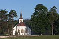
Saint Nicolas Church (1517)
Silo and train station

Alfred Rosselet fountain

La Vy Renaud


Personalities
- Salomé de Gélieu (1742–1820), educator and tutor at European princely courts, grew up in Les Verrières
- Esther de Gélieu (1757–1817), teacher, headmistress and educator, born in Les Verrières
- Charles-Henri Allamand (1776–1840), doctor in Val-de-Travers
- Frédéric Lambelet (1817–1876), member of the National Council, born in Les Verrières
- Jean Landry (1875–1940), electrical engineer and rector of EPFL , born in Meudon
- Georges Nagel (1899–1956), Egyptologist, born in Les Verrières
literature
- Jean Courvoisier: The Art Monuments of the Canton of Neuchâtel, Volume III: Les districts du Valde-Travers, du Val-de-Ruz, du Locle et de La Chaux-de-Fonds. (= Art Monuments of Switzerland. Volume 56). Edited by the Society for Swiss Art History GSK. Bern 1968.
Web links
- Website of the municipality of Les Verrières
- Eric-André Klauser: Les Verrières. In: Historical Lexicon of Switzerland .
Individual evidence
- ↑ Permanent and non-permanent resident population by year, canton, district, municipality, population type and gender (permanent resident population). In: bfs. admin.ch . Federal Statistical Office (FSO), August 31, 2019, accessed on December 22, 2019 .
- ^ Election du Conseil National du October 18, 2015, Résultats des partis - Les suffrages. (aspx) (No longer available online.) Chancellerie d'État neuchâtelois, October 18, 2015, archived from the original on November 1, 2015 ; Retrieved October 30, 2016 (French). Info: The archive link was inserted automatically and has not yet been checked. Please check the original and archive link according to the instructions and then remove this notice.
Boudry | Les Brenets | La Brévine | Bread plamboz | Le Cerneux-Péquignot | La Chaux-de-Fonds | La Chaux-du-Milieu | Corcelles-Cormondrèche | Cornaux | Cortaillod | La Côte-aux-Fées | Cressier | Tight | La Grande Béroche | Hauterive | Le Landeron | Lignières | Le Locle | Milvignes | Neuchâtel | Peseux | Les Planchettes | Les Ponts-de-Martel | Rochefort | La Sagne | Saint-Blaise | La Tène | Valangine | Val-de-Ruz | Val-de-Travers | Les Verrières
Former municipalities: Areuse | Auvernier | Les Bayards | Bevaix | Bôle | Boudevilliers | Boveresse | Bread lingerie | Bread dessus | Buttes | Cernier | Chézard-Saint-Martin | Coffrane | Colombier | Combes | La Coudre | Couvet | Dombresson | Engollon | Epagnier | Les Eplatures | Fenin | Fenin-Vilars-Saules | Fleurier | Fontainemelon | Fontaines | Fresens | Les Geneveys-sur-Coffrane | Gorgier | Les Hauts-Geneveys | Marin | Marin-Epagnier | Montalchez | Montmollin | Môtiers | Noiraigue | Le Pâquier | Plamboz | Saint-Aubin | Saint-Aubin-Sauges | Saint-Sulpice | Suction | Saules | Savagnier | Thielle-Wavre | Thielle | Travers | Vaumarcus | Vernéaz | Vilars | Villiers | Voëns-Maley | Wavre
Canton of Neuchâtel | Municipalities of the canton of Neuchâtel