Savagnier
| Savagnier | ||
|---|---|---|
| State : |
|
|
| Canton : |
|
|
| District : | No district division | |
| Municipality : | Val-de-Ruz | |
| Postal code : | 2065 | |
| former BFS no. : | 6484 | |
| Coordinates : | 563400 / 211110 | |
| Height : | 750 m above sea level M. | |
| Area : | 8.53 km² | |
| Residents: | 1220 (December 31, 2012) | |
| Population density : | 143 inhabitants per km² | |
| map | ||
|
|
||
Savagnier was a municipality in the Val-de-Ruz district in the canton of Neuchâtel in Switzerland . On January 1st, 2013 it merged with the municipalities of Boudevilliers , Cernier , Chézard-Saint-Martin , Coffrane , Dombresson , Engollon , Fenin-Vilars-Saules , Fontainemelon , Fontaines , Les Geneveys-sur-Coffrane , Les Hauts-Geneveys , Montmollin , Le Pâquier and Villiers to form the new municipality of Val-de-Ruz .
geography
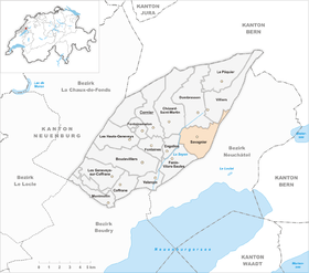
Savagnier is 750 m above sea level. M. , seven kilometers north-northeast of the canton capital Neuchâtel (linear distance ). The village extends in a hollow in the east of the Val de Ruz basin in the Neuchâtel Jura , at the northern foot of the Chaumont .
The area of the 9.6 km² municipal area comprises a section in the eastern part of the syncline of the Val de Ruz. The community soil extends from the agriculturally intensively used depression in the area of the Seyon brook to the east over the wooded steep slope ( Forêt de Savagnier ) to the height of the Chaumont Jura range (up to 1180 m above sea level ). In a narrow corner, the area extends northeast to the Grand Chaumont , on which at 1270 m above sea level. M. the highest point of Savagnier is reached. In 1997, 6% of the municipal area was accounted for by settlements, 44% by forests and woodlands and 50% by agriculture.
Savagnier consists of the two villages Petit Savagnier ( 737 m above sea level ) and Grand Savagnier ( 769 m above sea level ), which today have grown together structurally. On the Chaumont there are some individual farms and holiday homes. The neighboring municipalities of Savagnier are Chézard-Saint-Martin , Engollon , Fenin-Vilars-Saules , Neuchâtel , Enges , Villiers and Dombresson .
population
With 1220 inhabitants (as of December 31, 2012) Savagnier is one of the medium-sized communities in the canton of Neuchâtel. 92.9% of the residents are French-speaking, 3.7% German-speaking and 1.1% Portuguese-speaking (as of 2000). The population of Savagnier has fluctuated between 500 and 600 since 1850, but has increased significantly in recent decades.

economy
Until the middle of the 20th century, Savagnier was mainly an agricultural village. The fertile soils in the valley of the Val de Ruz form the basis of agriculture (mainly grain and maize), at the foot of the Chaumont there is cattle breeding . Outside the primary sector, there are some jobs in local small businesses (carpenters and locksmiths). In the last few decades Savagnier has developed into a residential community. Numerous workers are therefore commuters and work mainly in Neuchâtel.
traffic
The community is located away from the major thoroughfares on the cantonal road from Fenin-Vilars-Saules to Dombresson. The village is connected to the public transport network by a bus route from Neuchâtel via Savagnier to Cernier .
history
Traces of a Roman villa indicate an early settlement of the municipality. The place was first mentioned in writing in 1143 under the name Savaigner in a deed of donation from the Fontaine-André Abbey in Hauterive . The place name is probably derived from the Latin word silva ( forest ).
Savagnier belonged to the lordship of Valangin , which was partly subordinate to the Counts of Neuchâtel, partly to the Counts of Montbéliard and finally came to Neuchâtel in 1592. From 1648 Neuchâtel was a principality and from 1707 it was linked to the Kingdom of Prussia through personal union. In 1806 the area was ceded to Napoleon I and came to the Swiss Confederation in the course of the Congress of Vienna in 1815 , whereby the kings of Prussia until the Neuchâtel trade in 1857 also remained princes of Neuchâtel.
Attractions
Today's Reformed Church of Saint-Nicolas was built in 1651–53 as a single-nave building with a square choir. A previous church is mentioned as early as 1453. The schoolhouse was built in 1866. In both town centers there are still some characteristic farmhouses from the 17th to 19th centuries.
Web links
- Savagnier
- Maurice Evard: Savagnier. In: Historical Lexicon of Switzerland .
Individual evidence


