
La Cote-aux-Fées
| La Cote-aux-Fées | |
|---|---|
 |
|
| State : |
|
| Canton : |
|
| District : | No district division |
| BFS no. : | 6504 |
| Postal code : | 2117 |
| Coordinates : | 527 482 / 191 057 |
| Height : | 1041 m above sea level M. |
| Height range : | 863–1448 m above sea level M. |
| Area : | 12.83 km² |
| Residents: | 442 (December 31, 2018) |
| Population density : | 34 inhabitants per km² |
| Website: | www.lacote-aux-fees.ch |
 La Cote-aux-Fées |
|
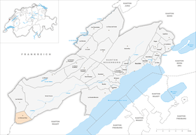
| Location of the municipality | |
  |
|
La Côte-aux-Fées is a municipality in the canton of Neuchâtel in Switzerland .
geography
La Côte-aux-Fées is located at 1041 m , 38 km west-southwest of the canton capital Neuchâtel (linear distance). The farming village extends on a slope sloping to the south above the Combe des Mulets valley , at the height of the southwestern Neuchâtel Jura .
The area of the 12.9 km² municipal area includes the Combe des Mulets valley, which is slightly sunk into the Jura plateau, and extends in the north to the height of Mont des Verrières (up to 1180 m ). In the south the border runs over the height of the Pâturages des Bourquin ( 1203 m ). To the east, the municipality extends over the ravine-like Vallon de Noirvaux , which is drained by the Buttes river, to the anticlines of the Chasseron . The highest point of La Côte-aux-Fées is reached on the Roches Blanches at 1430 m . On the Mont des Verrières in particular, there are extensive Jura high pastures with the typical mighty spruce trees , which either stand individually or in groups. In 1997, 3% of the municipal area was in settlements, 41% in forests and woodland, 55% in agriculture and a little less than 1% was unproductive land.
La Côte-aux-Fées includes the central town of Bolles de l'Eglise , the hamlets of Les Leuba ( 1038 m ), Bolles du Vent ( 1045 m ), Les Jeannet ( 1143 m ) and Les Places ( 1107 m ), all on the southern slope des Mont des Verrières, Les Bourquin de Vent ( 1078 m ) and Les Bourquin de Bise ( 1058 m ) at the height south of the Combe des Mulets, Saint-Olivier ( 1084 m ) on the plateau between La Côte-aux-Fées and the Vallon de Noirvaux, as well as numerous farm settlements and individual farms scattered across the Jura heights. In the forest above Saint-Olivier is the “Grotte aux Fées”. Neighboring municipalities of La Côte-aux-Fées are Les Verrières and Val-de-Travers in the canton of Neuchâtel, Sainte-Croix in the canton of Vaud and Les Fourgs and Verrières-de-Joux in neighboring France .

population
With 442 inhabitants (as of December 31, 2018), La Côte-aux-Fées is one of the smaller communities in the canton of Neuchâtel. 94% of the residents are French-speaking, 4% German-speaking and a good 1% Portuguese-speaking (as of 2000). The population of La Côte-aux-Fées increased continuously until 1900 (1096 inhabitants), since then it has decreased by more than half due to strong emigration.
politics
The voting shares of the parties at the 2015 National Council election were: SVP 38.7%, FDP 25.3%, SP 15.1%, CVP 6.4%, GPS 5.4%, glp 3.5%, PdA 3.2 %, BDP 2.1%.
economy
For a long time, La Côte-aux-Fées was mainly an agricultural village. From the 16th century iron ore was extracted in the municipality , which was processed in the Vallon de Noirvaux in blast furnaces that were in operation from the 17th to the 19th centuries. In the 18th century lace was first introduced, followed by watchmaking . A watch manufacture was opened in 1874. Today there are jobs in watchmaking, precision engineering and local small businesses. Agriculture with cattle breeding and dairy farming as well as wood processing are still important. Many workers are also commuters and work in the larger towns of the Val de Travers or in Sainte-Croix.
traffic
The community is far away from the major thoroughfares. The main access is from Buttes, there are other roads to Les Verrières and Sainte-Croix. From the Buttes train station, there is a post bus to La Côte-aux-Fées and, in some cases, to Sainte-Croix.
history
The first mention of the place comes from the year 1337 under the name Coste eis Faes ( sheep slope ). The area was not settled until the 14th century. La Côte-aux-Fées was under the jurisdiction of the Kastlanei Val-de-Travers until 1848. The county of Neuchâtel held sovereignty over the area. From 1648 Neuchâtel was a principality and from 1707 it was linked to the Kingdom of Prussia through personal union. In 1806 the area was ceded to Napoleon I and came to the Swiss Confederation in the course of the Congress of Vienna in 1815 , whereby the kings of Prussia until the Neuchâtel trade in 1857 also remained princes of Neuchâtel. It was not until 1826 that La Côte-aux-Fées, which previously belonged to the entire municipality of Les Verrières , became an independent political municipality. Around 1900 La Côte-aux-Fées was known as a mountain health resort.
Attractions
The church of La Côte-aux-Fées was built in 1658. In 1672 the place broke away from the parish of Les Verrières and has since formed its own parish. In the hamlets there are still some characteristic farmhouses of the Upper Jurassic.
Personalities
- Yvan Perrin (* 1966), Swiss politician (SVP)
literature
- Jean Courvoisier: The Art Monuments of the Canton of Neuchâtel, Volume III: Les districts du Valde-Travers, du Val-de-Ruz, du Locle et de La Chaux-de-Fonds. (= Art Monuments of Switzerland. Volume 56). Edited by the Society for Swiss Art History GSK. Bern 1968.
Web links
- Official website of the municipality of La Côte-aux-Fées (French)
- Eric-André Klauser / MF: Côte-aux-Fées, La. In: Historical Lexicon of Switzerland .
Individual evidence
- ↑ Permanent and non-permanent resident population by year, canton, district, municipality, population type and gender (permanent resident population). In: bfs. admin.ch . Federal Statistical Office (FSO), August 31, 2019, accessed on December 22, 2019 .
- ^ Election du Conseil National du October 18, 2015, Résultats des partis - Les suffrages. (aspx) (No longer available online.) Chancellerie d'État neuchâtelois, October 18, 2015, archived from the original on November 1, 2015 ; Retrieved October 30, 2016 (French). Info: The archive link was inserted automatically and has not yet been checked. Please check the original and archive link according to the instructions and then remove this notice.
Boudry | Les Brenets | La Brévine | Bread plamboz | Le Cerneux-Péquignot | La Chaux-de-Fonds | La Chaux-du-Milieu | Corcelles-Cormondrèche | Cornaux | Cortaillod | La Côte-aux-Fées | Cressier | Tight | La Grande Béroche | Hauterive | Le Landeron | Lignières | Le Locle | Milvignes | Neuchâtel | Peseux | Les Planchettes | Les Ponts-de-Martel | Rochefort | La Sagne | Saint-Blaise | La Tène | Valangine | Val-de-Ruz | Val-de-Travers | Les Verrières
Former municipalities: Areuse | Auvernier | Les Bayards | Bevaix | Bôle | Boudevilliers | Boveresse | Bread lingerie | Bread dessus | Buttes | Cernier | Chézard-Saint-Martin | Coffrane | Colombier | Combes | La Coudre | Couvet | Dombresson | Engollon | Epagnier | Les Eplatures | Fenin | Fenin-Vilars-Saules | Fleurier | Fontainemelon | Fontaines | Fresens | Les Geneveys-sur-Coffrane | Gorgier | Les Hauts-Geneveys | Marin | Marin-Epagnier | Montalchez | Montmollin | Môtiers | Noiraigue | Le Pâquier | Plamboz | Saint-Aubin | Saint-Aubin-Sauges | Saint-Sulpice | Suction | Saules | Savagnier | Thielle-Wavre | Thielle | Travers | Vaumarcus | Vernéaz | Vilars | Villiers | Voëns-Maley | Wavre
Canton of Neuchâtel | Municipalities of the canton of Neuchâtel