
Couvet
| Couvet | ||
|---|---|---|
 |
||
| State : |
|
|
| Canton : |
|
|
| District : | No district division | |
| Municipality : | Val-de-Travers | |
| Postal code : | 2108 | |
| former BFS no. : | 6505 | |
| Coordinates : | 538 708 / 197200 | |
| Height : | 735 m above sea level M. | |
| Area : | 16.41 km² | |
| Residents: | 2755 (December 31, 2007) | |
| Population density : | 168 inhabitants per km² | |
 Couvet |
||
| map | ||
|
||


Couvet was until December 31, 2008 a municipality in the Val-de-Travers district of the canton of Neuchâtel in Switzerland .
Since January 1, 2009 Couvet belongs together with Boveresse , Buttes , Fleurier , Les Bayards , Môtiers , Noiraigue , Saint-Sulpice and Travers merged to Val-de-Travers .
geography
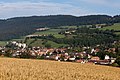
Couvet is 735 m above sea level. M. , 24 km west-southwest of the canton capital Neuchâtel (linear distance). The industrial community extends in the central Val de Travers on both sides of the Areuse and on the alluvial cone of the Sucre stream , in the southwestern Neuchâtel Jura .
The area of the 16.4 km² former municipal area comprises a section in the central part of the Val de Travers and belongs geologically to the Folded Jura . The main part is occupied by the 500 to 800 m wide, flat valley floor of the Areuse, which flows through the municipal area from the west-south-west to the east-north-east. The Areuse is pushed to the southern edge of the valley by the alluvial cone that Sucre, coming from the north, heaped up at Couvet when it entered the Val de Travers. To the south, the municipality extended over an initially gently but steeply rising and densely wooded slope in the upper part to the high plateau of Nouvelle Censière (up to 1110 m above sea level ), which lies on the anticlines of the Chasseron - Soliat chain.
In the north, the communal soil extended into the headwaters of the Sucre, which with its side streams has dug several erosion valleys into the Jura chain following north of the Val de Travers. The terrain here is therefore strongly embossed with the heights of Mont de Couvet ( 1024 m above sea level ), Malmont ( 1182 m above sea level ), Trémalmont ( 1277 m above sea level ) and Crêt du Cervelet (at 1294 m above sea level ) above sea level the highest point of Couvet); in some places the rocks of the Malmkalk come to light. In the far north the area extends into the Bois de Halle basin . At these heights there are extensive Jura high pastures with the typical mighty spruce trees , which either stand individually or in groups. In 1997, 10% of the municipal area was accounted for by settlements, 45% for forests and woodlands and 44% for agriculture; a little less than 1% was unproductive land.
Couvet included the hamlet of Plancemont ( 873 m above sea level ) on a ledge on the northern slope of the Val de Travers as well as some farm settlements and mountain farms. The neighboring communities of Couvet were Môtiers , Boveresse , La Brévine and Travers in the canton of Neuchâtel and Provence in the canton of Vaud .

population
| Population development | |
|---|---|
| year | Residents |
| Middle of the 14th century | 300 |
| 1554 | 500 |
| 1750 | 1004 |
| 1800 | 1463 |
| 1850 | 1704 |
| 1900 | 2430 |
| 1910 | 3352 |
| 1950 | 2897 |
| 1970 | 3481 |
| 1980 | 2627 |
| 1990 | 2919 |
| 2000 | 2703 |
With 2,755 inhabitants (end of 2007) Couvet was one of the larger municipalities in the canton of Neuchâtel. Of the residents, 85.1% are French-speaking, 4.6% Italian-speaking and 4.1% speak Portuguese (as of 2000). The population of Couvet has fluctuated strongly over the past 150 years, which reflects the economic situation of the village in the Val de Travers. Particularly high growth rates were recorded in the first decade of the 20th century and from 1950 to 1970, when the previous high was reached.
economy
Until the beginning of the 18th century, Couvet was mainly dominated by agriculture; in addition, various commercial and handicraft businesses developed since the 16th century. Of particular importance was the manufacture of earthenware and tiled stoves, in the middle of the 18th century an indienne manufacture and lace manufacture .
Couvet quickly developed into an industrial community from the middle of the 18th century. Numerous workshops for the manufacture of tools for the watch industry were set up. The absinthe distilleries Pernod, Duval, Berger were located in Couvet until 1910. In the 19th century the village experienced a further boom due to the introduction of new branches of industry (printing, card factory, brickworks). To the east of the village, the La Presta asphalt mine began to be exploited in 1840 . In 1867 the E. Dubied knitting machine factory was founded.
Today Couvet offers around 1200 jobs. With 5% of the gainfully employed who are still employed in the primary sector, agriculture ( arable farming in the valleys, dairy farming and cattle breeding mainly in higher areas) still has a certain role in the employment structure of the population. Around 40% of the workforce is employed in the industrial sector, while the service sector accounts for 55% of the workforce (as of 2001).
Today's industry includes construction, IT, packaging, wood processing, precision mechanics and the manufacture of knitting machines and watch accessories. Couvet is the location of the district hospital, which opened in 1860. More and more residents are commuting to work in the Neuchâtel region.
traffic
The former community is well developed in terms of traffic. It is located on the main road from Neuchâtel via the Les Verrières border crossing to Pontarlier in France . On July 25, 1860, the inauguration of the railway line from Auvernier to Les Verrières with a station in Couvet took place, which today forms part of the Neuchâtel-Pontarlier line. The train station in the upper part of the village has now been closed. On September 24, 1883, the Travers - Saint-Sulpice valley line was opened. This line with a train station near the old village center is now operated by the regional transport company Transports Régionaux Neuchâtelois (TRN SA). Bus routes, which operate the routes from Couvet to Fleurier and La Brévine , ensure the fine distribution of public transport .
history
The earliest evidence of human presence in the Couvet municipality dates back to the Paleolithic . The Grotte des Plaints was inhabited in Moustérien around 50,000 to 40,000 years ago before Christ.
The place was first mentioned in a document in 1300 under the name Covés . Later the names Coves (1380) and Covet (1470) appeared. The place name goes back to the Latin word cupa (barrel, large wooden vessel).
In the Middle Ages , Couvet initially belonged to the Saint-Pierre priory in the neighboring municipality of Môtiers. From the 14th century it was a member of the corporation of the Six Communes des Val-de-Travers. From the middle of the 14th century until 1848 it was under the control of Kastlanei Vautravers. During this time, the county of Neuchâtel had sovereignty over the area. From 1648 Neuchâtel was a principality and from 1707 it was linked to the Kingdom of Prussia through a personal union. In 1806 the area was ceded to Napoleon I and came to the Swiss Confederation in the course of the Congress of Vienna in 1815 , whereby the kings of Prussia until the Neuchâtel trade in 1857 also remained princes of Neuchâtel.
Rapid industrialization from the end of the 18th century made Couvet, along with Fleurier, the center of the Val de Travers. Unlike in Fleurier with its watchmaking industry, however, the machine industry was predominant in Couvet. Numerous absinthe distilleries were founded in the 19th century, so that Couvet became the center of absinthe production. The absinthe plant ( Artemisia absinthium ) was grown on large areas in the area . Due to the economic crises during the 20th century, each of which resulted in numerous plant closures, there were several strong population declines. However, the temporarily high unemployment rate could be absorbed by the establishment of new industrial companies.
Attractions
The reformed church of Couvet was built in 1658, the current front tower dates from 1756 to 1766. The Hôtel Communal with a small portico was built in 1739, the Maison de l'Ecu de France in 1690. In the old town center and in stately houses and villas from the period of industrialization have been preserved in the vicinity, including the Hôtel de l'Aigle (1778) and the 18th century manor house of Le Marais. The Free Church's chapel was built in 1876, while the Catholic chapel dates from 1943.
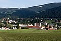
Couvet, industrial zone
Couvet, village center

Collège (school)

Collège (school)

reformed Church

Catholic Church

Salle de Spéctacle

Hotel de l'Aigle

Railway viaduct


Personalities
- Emer de Vattel (1714–1767), international lawyer
- Ferdinand Berthoud (1727–1807), inventor of the marine chronometer
- Henri Edouard Dubied (1823–1878), textile industrialist
- François Borel (1842–1924), engineer
- Alfred Rosselet (1887–1950), radiologist and rector of the University of Lausanne
- Denis de Rougemont (1906–1985), political philosopher
- Anthony Huguenin (born 1991), ice hockey player
literature
- Jean Courvoisier: The Art Monuments of the Canton of Neuchâtel, Volume III: Les districts du Valde-Travers, du Val-de-Ruz, du Locle et de La Chaux-de-Fonds. (= Art Monuments of Switzerland. Volume 56). Edited by the Society for Swiss Art History GSK. Bern 1968.
- Hugues Jéquier: Le Val-de-Travers des origines au XIVe siècle. La Baconniere, Neuchatel 1962.
- Sylvia Robert: L'industrie dentellière dans les Montagnes neuchâteloises aux XIIIe et XIVe siècles. In Musée neuchâtelois, 1988, pp. 69–95.
Web links
- Information about the former municipality of Couvet
- Eric-André Klauser: Couvet. In: Historical Lexicon of Switzerland .
- Aerial views of the village
Boudry | Les Brenets | La Brévine | Bread plamboz | Le Cerneux-Péquignot | La Chaux-de-Fonds | La Chaux-du-Milieu | Corcelles-Cormondrèche | Cornaux | Cortaillod | La Côte-aux-Fées | Cressier | Tight | La Grande Béroche | Hauterive | Le Landeron | Lignières | Le Locle | Milvignes | Neuchâtel | Peseux | Les Planchettes | Les Ponts-de-Martel | Rochefort | La Sagne | Saint-Blaise | La Tène | Valangine | Val-de-Ruz | Val-de-Travers | Les Verrières
Former municipalities: Areuse | Auvernier | Les Bayards | Bevaix | Bôle | Boudevilliers | Boveresse | Bread lingerie | Bread dessus | Buttes | Cernier | Chézard-Saint-Martin | Coffrane | Colombier | Combes | La Coudre | Couvet | Dombresson | Engollon | Epagnier | Les Eplatures | Fenin | Fenin-Vilars-Saules | Fleurier | Fontainemelon | Fontaines | Fresens | Les Geneveys-sur-Coffrane | Gorgier | Les Hauts-Geneveys | Marin | Marin-Epagnier | Montalchez | Montmollin | Môtiers | Noiraigue | Le Pâquier | Plamboz | Saint-Aubin | Saint-Aubin-Sauges | Saint-Sulpice | Suction | Saules | Savagnier | Thielle-Wavre | Thielle | Travers | Vaumarcus | Vernéaz | Vilars | Villiers | Voëns-Maley | Wavre
Canton of Neuchâtel | Municipalities of the canton of Neuchâtel