
Lasagne
| Lasagne | |
|---|---|
 |
|
| State : |
|
| Canton : |
|
| District : | No district division |
| BFS no. : | 6423 |
| Postal code : | 2314 |
| UN / LOCODE : | CH SGN |
| Coordinates : | 551465 / 209961 |
| Height : | 1039 m above sea level M. |
| Height range : | 1001–1331 m above sea level M. |
| Area : | 25.55 km² |
| Residents: | 1019 (December 31, 2018) |
| Population density : | 40 inhabitants per km² |
| Website: | www.lasagne.ch |
 Street line village of La Sagne |
|
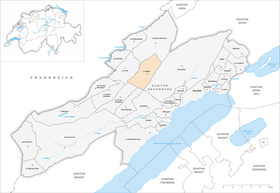
| Location of the municipality | |
  |
|
La Sagne is a town and a municipality in the canton of Neuchâtel in Switzerland .
geography
La Sagne is 1039 meters above sea level. M. , 6 km south-southwest of the district capital La Chaux-de-Fonds (linear distance). The approximately 2.5 km long street-line village extends in the northeast of the high valley Vallée des Ponts in the Neuchâtel Jura , west of the heights of Tête de Ran and Mont Racine .
The area of the municipal area of 25.6 km² covers the entire north-eastern section of the Vallée des Ponts, which has a flat valley floor of around 500 m in the upper part and a flat valley floor over 1 km wide in the lower part. The valley is drained by the Grand Bied . The eastern border largely follows the edge of the forest above the Côtes de Marmoud on the anticlines of Mont Racine. To the west, the municipality extends over the height of Mont Sagne ( 1263 m above sea level ) in the catchment area of the Rançonnière flowing to the Doubs . The Entre deux Monts Dessus basin above Le Locle is also part of La Sagne. The highest point of the community is at 1331 m above sea level. M. in the far west at the Grand Som Martel . On the Jura heights, especially on the Communal de La Sagne, wide high pastures with the typical mighty spruce trees stretch out, either individually or in groups. In 1997, 3% of the municipal area was accounted for by settlements, 37% by forests and woodlands and 60% by agriculture.
The approximately 2.5 km long street-line village of La Sagne consists of the districts of Les Coeudres ( 1012 m above sea level ), Le Crêt ( 1032 m above sea level ), Miéville ( 1037 m above sea level ), La Sagne-Église ( 1039 m above sea level ) and La Corbatière ( 1080 m above sea level ), all of which are on the west side of the high valley along the road from Les Ponts-de-Martel to La Chaux-de-Fonds. The central place is Le Crêt. On the east side of the Vallée des Ponts below the Côtes de Marmoud is the hamlet of Marmoud ( 1026 m above sea level ). There are numerous individual farms scattered across the Jura heights. The neighboring municipalities of La Sagne are La Chaux-de-Fonds , Le Locle , Les Ponts-de-Martel , Brot-Plamboz , Rochefort and Val-de-Ruz .

population
| Population development | |
|---|---|
| year | Residents |
| 1850 | 1800 |
| 1860 | 1989 |
| 1900 | 1565 |
| 1950 | 1057 |
| 1960 | 1061 |
| 1970 | 984 |
| 1980 | 929 |
| 1990 | 902 |
| 2000 | 997 |
With 1019 inhabitants (as of December 31, 2018), La Sagne is one of the smaller municipalities in the canton of Neuchâtel. 94.9% of the residents are French-speaking, 2.9% German-speaking and 0.8% Italian-speaking (as of 2000). After a peak around 1860 with around 2000 inhabitants, a marked decrease in the number of inhabitants of around 50% was recorded by 1950 due to strong emigration. Since then, various fluctuations have been observed, with the population hovering around the thousand mark.
politics
The voting shares of the parties at the 2015 National Council election were: SVP 29.9%, FDP 23.9%, SP 16.7%, PdA 13.0%, GPS 8.9%, glp 2.9%, CVP 2.3 %, Nouveau Parti Libéral 1.3%, BDP 0.5%.
economy
La Sagne is still today an agricultural village, with horse breeding and dairy farming predominating. Outside the primary sector, there are jobs in a furniture factory, in watchmaking companies and in local small businesses. Many people in employment are also commuters and work in La Chaux-de-Fonds, Le Locle or Neuchâtel.
Previously, peat been stung.
traffic
The community is located away from the major thoroughfares on the cantonal road from La Chaux-de-Fonds to Les Ponts-de-Martel. La Sagne is connected to the public transport network through the meter-gauge railway line of the former Ponts – Sagne – Chaux-de-Fonds-Bahn (PSC), which has been operated by Transports Régionaux Neuchâtelois (TRN) since 1999 . On the railway line, which opened on July 26, 1889, there are further stops in La Corbatière, La Sagne-Église, Le Crêt and Les Coeudres.
history

The first written mention of the place took place in the early 14th century. The partly boggy area of La Sagne was made arable during this time by settlers from the canton of Vaud and the Val de Ruz, because the Lords of Valangin guaranteed extensive tax exemption. The name Sagne is the Latin word sagna ( sedge due).
In the following years La Sagne came under the jurisdiction of the Valangin rule , which finally came to Neuchâtel in 1592. Neuchâtel had been a principality since 1648 and after the death of Neuchâtel Princess Marie de Nemours from the French house of Orléans-Longueville , the Prussian king and French princes applied for their successor. The Neuchâtel estates chose their sovereign themselves. The King of Prussia was their choice because he was Protestant and ready to continue to recognize the rights of freedom. The city and republic of Bern were happy if the power of France was contained. In 1806, the area was ceded to Napoleon I in a barter (against Hanover) and came to the Swiss Confederation in the course of the Congress of Vienna in 1815 , whereby the kings of Prussia remained formally princes of Neuchâtel until 1857.
In 1848, Republicans overturned the government in Neuchâtel and drafted a new constitution. La Sagne voted against the new constitution, which was adopted by a majority, with more than 90 percent of the vote. According to the international point of view, the king still had a claim to Neuchâtel, but undertook in 1852 not to use force. On September 3, 1856, the Neunburg monarchists carried out a coup from La Sagne. They took the government palace in Neuchâtel. However, after a day they capitulate. The announced mobilizations of Prussia and the Swiss Confederation resulted in the Neuchâtel trade .
Attractions
The first chapel was built in La Sagne as early as 1350. The current construction of the Gothic church dates back to a little after 1500. Le Crêt is home to the parish hall (Hôtel de commune) and the remarkable four-story Maison de la Croix Blanche from 1782. La Sagne has numerous farmhouses from the 17th to 19th centuries Century preserved in the type of Freiberg Jura house.
photos

La Sagne-Église in winter

La Sagne-Église in summer

La Sagne-Église train station

La Sagne-Mieville

La Sagne-Mieville schoolhouse

Les Coeudres


Personalities
La Sagne is the birthplace of Daniel Jean Richard , who is considered to be the pioneer of the Jurassic watch industry.
Web links
- Official website of the municipality of La Sagne (French)
- Caroline Calame: Sagne, La. In: Historical Lexicon of Switzerland .
Individual evidence
- ↑ Permanent and non-permanent resident population by year, canton, district, municipality, population type and gender (permanent resident population). In: bfs. admin.ch . Federal Statistical Office (FSO), August 31, 2019, accessed on December 22, 2019 .
- ^ Election du Conseil National du October 18, 2015, Résultats des partis - Les suffrages. (aspx) (No longer available online.) Chancellerie d'État neuchâtelois, October 18, 2015, archived from the original on November 1, 2015 ; Retrieved October 30, 2016 (French). Info: The archive link was inserted automatically and has not yet been checked. Please check the original and archive link according to the instructions and then remove this notice.
- ↑ a b Vive le Roi! Preussen im Hochmoor , NZZ, August 24, 2016
Boudry | Les Brenets | La Brévine | Bread plamboz | Le Cerneux-Péquignot | La Chaux-de-Fonds | La Chaux-du-Milieu | Corcelles-Cormondrèche | Cornaux | Cortaillod | La Côte-aux-Fées | Cressier | Tight | La Grande Béroche | Hauterive | Le Landeron | Lignières | Le Locle | Milvignes | Neuchâtel | Peseux | Les Planchettes | Les Ponts-de-Martel | Rochefort | La Sagne | Saint-Blaise | La Tène | Valangine | Val-de-Ruz | Val-de-Travers | Les Verrières
Former municipalities: Areuse | Auvernier | Les Bayards | Bevaix | Bôle | Boudevilliers | Boveresse | Bread lingerie | Bread dessus | Buttes | Cernier | Chézard-Saint-Martin | Coffrane | Colombier | Combes | La Coudre | Couvet | Dombresson | Engollon | Epagnier | Les Eplatures | Fenin | Fenin-Vilars-Saules | Fleurier | Fontainemelon | Fontaines | Fresens | Les Geneveys-sur-Coffrane | Gorgier | Les Hauts-Geneveys | Marin | Marin-Epagnier | Montalchez | Montmollin | Môtiers | Noiraigue | Le Pâquier | Plamboz | Saint-Aubin | Saint-Aubin-Sauges | Saint-Sulpice | Suction | Saules | Savagnier | Thielle-Wavre | Thielle | Travers | Vaumarcus | Vernéaz | Vilars | Villiers | Voëns-Maley | Wavre
Canton of Neuchâtel | Municipalities of the canton of Neuchâtel