
Boveresse
| Boveresse | ||
|---|---|---|
 |
||
| State : |
|
|
| Canton : |
|
|
| District : | No district division | |
| Municipality : | Val-de-Travers | |
| Postal code : | 2113 | |
| former BFS no. : | 6502 | |
| UN / LOCODE : | CH BOV | |
| Coordinates : | 536 227 / 196671 | |
| Height : | 735 m above sea level M. | |
| Area : | 12.90 km² | |
| Residents: | 392 (December 31, 2007) | |
| Population density : | 30 inhabitants per km² | |
 Temple |
||
| map | ||
|
||


Boveresse was until December 31, 2008 a municipality in the Val-de-Travers district of the canton of Neuchâtel in Switzerland .
Since January 1, 2009 Boveresse belongs together with Buttes , Couvet , Fleurier , Les Bayards , Môtiers , Noiraigue , Saint-Sulpice and Travers merged to Val-de-Travers .
geography
Boveresse is 735 m above sea level. M. , 26 km west-southwest of the canton capital Neuchâtel (linear distance). The village extends on the northern edge of the Val de Travers across from Môtiers in the Neuchâtel Jura .
The area of the 12.9 km² former municipal area comprises a small section of the Val de Travers, which is almost 2 km wide. The southern border forms the Vieille Areuse , a former arm of the Areuse , which has been corrected and straightened in this area. The municipality extended north over the flat valley floor of the Val de Travers to the north adjacent Jura heights ( Monts de Boveresse , up to 1213 m above sea level ). In the far north, the area extended to the anticline that accompanies the Vallée de la Brévine in the south. Here was with 1240 m above sea level. M. reached the highest point of Boveresse. To the north-east, the municipality extended over the basin of the Sucre brook to the Trémalmont ( 1213 m above sea level ). On the heights north of Boveresse there are extensive Jura high pastures with the typical mighty spruce trees , which either stand individually or in groups. In 1997, 4% of the municipal area was settled, 45% forest and woodland, 50% agriculture and a little less than 1% was unproductive land.
Numerous farm settlements and individual farms on the Jura heights belonged to Boveresse. Neighboring municipalities to Boveresse were Saint-Sulpice , Fleurier , Môtiers , Couvet and La Brévine .
population
With 392 inhabitants (at the end of 2007), Boveresse was one of the small communities in the canton of Neuchâtel. 93.9% of the residents are French-speaking, 2.9% Italian-speaking and 1.7% German-speaking (as of 2000). After 1900 (577 inhabitants) the population of Boveresse decreased significantly until 1950 (388 inhabitants), since then the population has fluctuated between 350 and 400 inhabitants.
economy
Boveresse was mainly an agricultural village until the 20th century . In the course of the 19th century, some watchmaking companies settled in the village . An important line of business for the residents of Boveresse was the cultivation of the absinthe plant ( Artemisia absinthium ) for the production of absinthe , which was banned in 1908 due to a referendum. An ice cave in the Montlési area was used as a storage area for ice around 1900.
In the last few decades Boveresse had developed into a residential community. Today around 40% of the workforce still make a living from agriculture, in particular from cattle breeding , dairy farming and fodder cultivation . Outside the primary sector there are jobs in local small businesses. However, many employed people are commuters who work in the larger towns of the Val de Travers and in Neuchâtel .
traffic
The former community is well developed in terms of traffic. It is located on the main road from Neuchâtel via the Les Verrières border crossing to Pontarlier in France . On July 25, 1860, the railway line from Auvernier to Les Verrières was opened with a station in Boveresse. Today, however, regional trains no longer operate on the Travers - Les Verrières route . The village is connected to the public transport network by the PostBus course from Couvet to Les Verrières and partly on to Pontarlier. Another course operates on the route from Fleurier to La Brévine.
history
The place was first mentioned in writing in 1266 under the name Boveressa , which goes back to the Latin boveretum ( pasture for cattle ). Boveresse belonged to the priory of Saint-Pierre in the neighboring parish of Môtiers until the 14th century, after which it was subject to the Kastlanei Val-de-Travers until 1848. During this time, the county of Neuchâtel had sovereignty over the area. From 1648 Neuchâtel was a principality and from 1707 it was linked to the Kingdom of Prussia through personal union. In 1806 the area was ceded to Napoleon I and came to the Swiss Confederation in the course of the Congress of Vienna in 1815 , whereby the kings of Prussia until the Neuchâtel trade in 1857 also remained princes of Neuchâtel.
Attractions
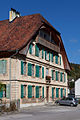
The Chapel of Boveresse was built in 1768, the tower dates from 1861. In the center of the village there are some characteristic farmhouses and town houses from the 18th and 19th centuries, including the Maison des Chats of the Petitpierre family.

Séchoir (protection of cultural property)
Maison des Chats (protection of cultural property)


literature
- Jean Courvoisier: The Art Monuments of the Canton of Neuchâtel, Volume III: Les districts du Valde-Travers, du Val-de-Ruz, du Locle et de La Chaux-de-Fonds. (= Art Monuments of Switzerland. Volume 56). Edited by the Society for Swiss Art History GSK. Bern 1968.
Web links
- Community information Boveresse
- Eric-André Klauser: Boveresse. In: Historical Lexicon of Switzerland .
Boudry | Les Brenets | La Brévine | Bread plamboz | Le Cerneux-Péquignot | La Chaux-de-Fonds | La Chaux-du-Milieu | Corcelles-Cormondrèche | Cornaux | Cortaillod | La Côte-aux-Fées | Cressier | Tight | La Grande Béroche | Hauterive | Le Landeron | Lignières | Le Locle | Milvignes | Neuchâtel | Peseux | Les Planchettes | Les Ponts-de-Martel | Rochefort | La Sagne | Saint-Blaise | La Tène | Valangine | Val-de-Ruz | Val-de-Travers | Les Verrières
Former municipalities: Areuse | Auvernier | Les Bayards | Bevaix | Bôle | Boudevilliers | Boveresse | Bread lingerie | Bread dessus | Buttes | Cernier | Chézard-Saint-Martin | Coffrane | Colombier | Combes | La Coudre | Couvet | Dombresson | Engollon | Epagnier | Les Eplatures | Fenin | Fenin-Vilars-Saules | Fleurier | Fontainemelon | Fontaines | Fresens | Les Geneveys-sur-Coffrane | Gorgier | Les Hauts-Geneveys | Marin | Marin-Epagnier | Montalchez | Montmollin | Môtiers | Noiraigue | Le Pâquier | Plamboz | Saint-Aubin | Saint-Aubin-Sauges | Saint-Sulpice | Suction | Saules | Savagnier | Thielle-Wavre | Thielle | Travers | Vaumarcus | Vernéaz | Vilars | Villiers | Voëns-Maley | Wavre
Canton of Neuchâtel | Municipalities of the canton of Neuchâtel