
Le Cerneux-Péquignot
| Le Cerneux-Péquignot | |
|---|---|
 |
|
| State : |
|
| Canton : |
|
| District : | No district division |
| BFS no. : | 6434 |
| Postal code : | 2414 |
| Coordinates : | 541309 / 207 736 |
| Height : | 1088 m above sea level M. |
| Height range : | 1041–1289 m above sea level M. |
| Area : | 15.70 km² |
| Residents: | 311 (December 31, 2018) |
| Population density : | 20 inhabitants per km² |
| Website: | www.cerneux-pequignot.ch |
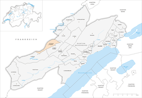
| Location of the municipality | |
  |
|
Le Cerneux-Péquignot is a municipality in the canton of Neuchâtel in Switzerland .
geography
Le Cerneux-Péquignot is 1088 m above sea level. M. in the center of the village is the highest municipality in the canton of Neuchâtel, 8 km southwest of Le Locle (linear distance). The farming village extends northeast of the high valley Vallée de la Brévine in the Neuchâtel Jura , near the border with France .
The area of the municipal area of 15.7 km² covers a section in the undulating landscape of the Neuchâtel Jura south of the Doube valley . The landscape shows a similar character to that of the Franches-Montagnes (German Freiberge ) with boggy, mostly above-ground drainage-free depressions between limestone peaks . Here there are extensive Jura high pastures with the typical mighty spruce trees , which either stand individually or in groups. In some places there are also sinkholes . To the north of the village, the parish includes the ridge des Prévoux ( 1261 m above sea level ) and extends over the Bas des Roussottes valley to the wooded ridge Maix Musy , on which at 1285 m above sea level. M. the highest point of Le Cerneux-Péquignot is reached. To the east, the area extends over the Bois du Creux ( 1151 m above sea level ) and the Petit Calirou ( 1155 m above sea level ) to the Signal ( 1155 m above sea level ). The southern border lies in the middle of the depression of the eastern Vallée de la Brévine. In a long narrow strip, the area of the municipality extends to the southwest to the Châteleu forest height ( 1260 m above sea level ) northwest of the village of La Brévine. In 1997, 3% of the municipal area was in settlements, 40% in forests and woodlands, 55% in agriculture and around 2% was unproductive land.
Le Cerneux-Péquignot includes the hamlets of Bas du Cerneux ( 1078 m above sea level ) west of the village, Le Gigot ( 1080 m above sea level ) on the edge of the Le Chauchet moor, the southern part of Le Prévoux ( 1077 m above sea level) . M. ) east of the height of the same name on the descent into the high valley of Le Locle as well as numerous farm settlements and individual farms scattered across the Jura heights. Neighboring municipalities of Le Cerneux-Péquignot are La Brévine , La Chaux-du-Milieu and Le Locle in the canton of Neuchâtel and Villers-le-Lac , Montlebon and Grand'Combe-Châteleu in neighboring France .
population


With 311 inhabitants (as of December 31, 2018), Le Cerneux-Péquignot is one of the small communities in the canton of Neuchâtel. 95.6% of the residents are French-speaking, 2.6% German-speaking and 1.0% Portuguese-speaking (as of 2000). The population of Le Cerneux-Péquignot increased slightly from 1850 (301 inhabitants) to 1950 (410 inhabitants), after which a strong emigration was registered until 1980 (290 inhabitants). Since then there has been a slight increase again.
politics
The voting shares of the parties at the 2015 National Council election were: SVP 32.4%, FDP 29.8%, SP 14.8%, PdA 11.1%, GPS 7.8%, CVP 2.0%, glp 1.7 %, BDP 0%.
economy
To this day, Le Cerneux-Péquignot is mainly an agricultural village, with livestock and dairy farming predominating. Cheese production and forestry also have a certain importance. Since the 18th century, peat was cut in the Marais Rouge in the valley of the Vallée de la Brévine ; In 1991 peat mining was stopped.
traffic
The municipality is located off the major thoroughfares on the cantonal road from Fleurier to Le Locle . To the west of the village there is a border crossing to Morteau in France. Le Cerneux-Péquignot is connected to the public transport network by the PostBus course that runs from La Brévine to Le Locle.
history
The area around the current town was probably reclaimed in the 13th century by the Péquignot family from the municipality of Montlebon in France. Cerneux is derived from the Latin word circinatus ( fenced ), which means the fenced-in land of a courtyard. From its foundation until the French Revolution, the village belonged to the Morteau Priory, which was under the Free County of Burgundy . From 1325 to 1521, Le Cerneux-Péquignot belonged to the jurisdiction of the Counts of Neuchâtel. During the Thirty Years War the place was partially destroyed.
After the fall of the Ancien Régime, Le Cerneux-Péquignot belonged to France until 1814, but was then ceded to the Principality of Neuchâtel. However, the final takeover by Switzerland did not take place until 1819.
Attractions

The Notre-Dame-de-la-Visitation church was built in 1690 and contains an important baroque altar . In the village and in the hamlets there are numerous characteristic farmhouses of the Upper Jurassic from the 17th to 19th centuries.
Web links
- Official website of the municipality of Le Cerneux-Péquignot (French)
- Maurice Evard: Cerneux-Péquignot, Le. In: Historical Lexicon of Switzerland .
Individual evidence
- ↑ Permanent and non-permanent resident population by year, canton, district, municipality, population type and gender (permanent resident population). In: bfs. admin.ch . Federal Statistical Office (FSO), August 31, 2019, accessed on December 22, 2019 .
- ^ Election du Conseil National du October 18, 2015, Résultats des partis - Les suffrages. (aspx) (No longer available online.) Chancellerie d'État neuchâtelois, October 18, 2015, archived from the original on November 1, 2015 ; Retrieved October 30, 2016 (French). Info: The archive link was inserted automatically and has not yet been checked. Please check the original and archive link according to the instructions and then remove this notice.
Boudry | Les Brenets | La Brévine | Bread plamboz | Le Cerneux-Péquignot | La Chaux-de-Fonds | La Chaux-du-Milieu | Corcelles-Cormondrèche | Cornaux | Cortaillod | La Côte-aux-Fées | Cressier | Tight | La Grande Béroche | Hauterive | Le Landeron | Lignières | Le Locle | Milvignes | Neuchâtel | Peseux | Les Planchettes | Les Ponts-de-Martel | Rochefort | La Sagne | Saint-Blaise | La Tène | Valangine | Val-de-Ruz | Val-de-Travers | Les Verrières
Former municipalities: Areuse | Auvernier | Les Bayards | Bevaix | Bôle | Boudevilliers | Boveresse | Bread lingerie | Bread dessus | Buttes | Cernier | Chézard-Saint-Martin | Coffrane | Colombier | Combes | La Coudre | Couvet | Dombresson | Engollon | Epagnier | Les Eplatures | Fenin | Fenin-Vilars-Saules | Fleurier | Fontainemelon | Fontaines | Fresens | Les Geneveys-sur-Coffrane | Gorgier | Les Hauts-Geneveys | Marin | Marin-Epagnier | Montalchez | Montmollin | Môtiers | Noiraigue | Le Pâquier | Plamboz | Saint-Aubin | Saint-Aubin-Sauges | Saint-Sulpice | Suction | Saules | Savagnier | Thielle-Wavre | Thielle | Travers | Vaumarcus | Vernéaz | Vilars | Villiers | Voëns-Maley | Wavre
Canton of Neuchâtel | Municipalities of the canton of Neuchâtel