
Bread plamboz
| Bread plamboz | |
|---|---|
 |
|
| State : |
|
| Canton : |
|
| District : | No district division |
| BFS no. : | 6433 |
| Postal code : | 2318 |
| Coordinates : | 546 754 / 202 589 |
| Height : | 1012 m above sea level M. |
| Height range : | 985–1272 m above sea level M. |
| Area : | 16.09 km² |
| Residents: | 270 (December 31, 2018) |
| Population density : | 17 inhabitants per km² |
| Website: | www.brot-plamboz.ch |
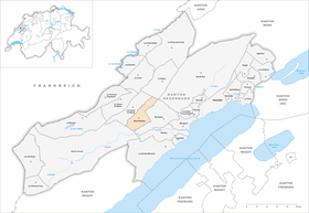
| Location of the municipality | |
  |
|
Brot-Plamboz is a municipality in the canton of Neuchâtel in Switzerland .
geography
Brot-Plamboz is 1012 m above sea level. M. , 15 km west of the canton capital Neuchâtel (linear distance). The farming village extends on the southeast edge of the Vallée des Ponts high valley in the Neuchâtel Jura , west of the La Tourne pass and at the northern foot of the Solmon .
The area of the 16.1 km² municipal area comprises the eastern part of the southern section of the Vallée des Ponts. The Bied brook forms the western border . The high valley in the area of Brot-Plamboz is completely flat and partly swampy ( Marais de Brot ). In the south, the border runs over a slight elevation that forms the natural end of the valley to the Val de Travers . In the south-east, the municipality extends to the wooded ridge of the Solmon ( 1263 m above sea level ) and in the east to the level of the Montagne de Plamboz in the area of the La Tourne pass. Here there are extensive Jura high pastures with the typical mighty spruce trees , which either stand individually or in groups. A narrow strip of the area extends far to the northeast and includes the valley of the Vallée des Ponts to the east of the Bied and the slope of the anticlines of Mont Racine to the east . The highest point of Brot-Plamboz is at 1270 m above sea level. M. on the western slope of Mont Racine. In 1997, 3% of the municipal area was in settlements, 28% in forests and woodlands, 68% in agriculture and a little less than 1% was unproductive land.
The municipality of Brot-Plamboz consists of the villages of Brot-Dessus ( 1012 m above sea level ) and Plamboz ( 1017 m above sea level , at the western foot of Mont Racine) and the hamlets of Vers chez les Brandt ( 1008 m above sea level). ), Les Petits Ponts ( 1007 m above sea level ), all along the road on the eastern edge of the Vallée des Ponts, and Le Joratel ( 1022 m above sea level ) on the southern edge of the high valley. In addition, numerous individual farms belong to Brot-Plamboz, scattered across the Jura heights. Neighboring communities of Brot-Plamboz are Les Ponts-de-Martel , Val-de-Travers , Rochefort , Val-de-Ruz and La Sagne .

population
With 270 inhabitants (as of December 31, 2018), Brot-Plamboz is one of the small communities in the canton of Neuchâtel. 99.2% of the residents are French-speaking and 0.8% German-speaking (as of 2000). The population of Brot-Plamboz decreased from 1880 (391 inhabitants) to 1990 (237 inhabitants), since then there has been a slight increase again.
politics
The voting shares of the parties in the 2015 National Council election were: SVP 40.4%, FDP 26.6%, SP 13.4%, PdA 5.9%, GPS 5.3%, CVP 4.7%, Nouveau Parti Libéral 2 , 6%, glp 0.4%, BDP 0%.
economy
Bread-Plamboz is still a village dominated by agriculture , with cattle breeding and dairy farming as well as cheese production predominating. During the 19th century, numerous residents made their living in watchmaking . Since the 18th century, peat was cut in the moorlands of the Vallée des Ponts ; In 1991 peat mining was stopped. The only industrial company is a drainage plant that carries out orders throughout Switzerland.
traffic
The community is located away from the major thoroughfares on a cantonal road from Val de Travers to La Chaux-de-Fonds . The hamlet of Les Petits Ponts is located at the intersection of this road with the main road from Neuchâtel via Les Ponts-de-Martel to Le Locle . Les Petits Ponts is served by the postbus course from Neuchâtel to Le Locle, the other hamlets are not connected to the public transport network.
history
The place name Broch is mentioned for the first time in 998. It is probably due to the old French word broc ( rock spur ). Bread-Dessus made with bread lingerie the community bread , which in the Middle Ages to rule Boudry belonged. In the early 14th century this came to the county of Neuchâtel. From 1648 Neuchâtel was a principality and from 1707 it was linked to the Kingdom of Prussia through a personal union. In 1806 the area was ceded to Napoleon I and came to the Swiss Confederation in the course of the Congress of Vienna in 1815 , whereby the kings of Prussia until the Neuchâtel trade in 1857 also remained princes of Neuchâtel.
From 1848, bread belonged to the Boudry district . In 1888, the parts of the municipality of Brot located in the Vallée des Ponts dissolved and merged with Plamboz to form the new municipality of Brot-Plamboz. The parish does not have its own church; it has belonged to the parish of Les Ponts-de-Martel since 1685.
Web links
- Christine Müller: Bread Plamboz. In: Historical Lexicon of Switzerland .
Individual evidence
- ↑ Permanent and non-permanent resident population by year, canton, district, municipality, population type and gender (permanent resident population). In: bfs. admin.ch . Federal Statistical Office (FSO), August 31, 2019, accessed on December 22, 2019 .
- ^ Election du Conseil National du October 18, 2015, Résultats des partis - Les suffrages. (aspx) (No longer available online.) Chancellerie d'État neuchâtelois, October 18, 2015, archived from the original on November 1, 2015 ; Retrieved October 30, 2016 (French). Info: The archive link was inserted automatically and has not yet been checked. Please check the original and archive link according to the instructions and then remove this notice.
Boudry | Les Brenets | La Brévine | Bread plamboz | Le Cerneux-Péquignot | La Chaux-de-Fonds | La Chaux-du-Milieu | Corcelles-Cormondrèche | Cornaux | Cortaillod | La Côte-aux-Fées | Cressier | Tight | La Grande Béroche | Hauterive | Le Landeron | Lignières | Le Locle | Milvignes | Neuchâtel | Peseux | Les Planchettes | Les Ponts-de-Martel | Rochefort | La Sagne | Saint-Blaise | La Tène | Valangine | Val-de-Ruz | Val-de-Travers | Les Verrières
Former municipalities: Areuse | Auvernier | Les Bayards | Bevaix | Bôle | Boudevilliers | Boveresse | Bread lingerie | Bread dessus | Buttes | Cernier | Chézard-Saint-Martin | Coffrane | Colombier | Combes | La Coudre | Couvet | Dombresson | Engollon | Epagnier | Les Eplatures | Fenin | Fenin-Vilars-Saules | Fleurier | Fontainemelon | Fontaines | Fresens | Les Geneveys-sur-Coffrane | Gorgier | Les Hauts-Geneveys | Marin | Marin-Epagnier | Montalchez | Montmollin | Môtiers | Noiraigue | Le Pâquier | Plamboz | Saint-Aubin | Saint-Aubin-Sauges | Saint-Sulpice | Suction | Saules | Savagnier | Thielle-Wavre | Thielle | Travers | Vaumarcus | Vernéaz | Vilars | Villiers | Voëns-Maley | Wavre
Canton of Neuchâtel | Municipalities of the canton of Neuchâtel