
Boudevilliers
| Boudevilliers | ||
|---|---|---|
 |
||
| State : |
|
|
| Canton : |
|
|
| District : | No district division | |
| Municipality : | Val-de-Ruz | |
| Postal code : | 2043 | |
| former BFS no. : | 6471 | |
| Coordinates : | 558318 / 208 827 | |
| Height : | 753 m above sea level M. | |
| Area : | 12.57 km² | |
| Residents: | 764 (December 31, 2012) | |
| Population density : | 61 inhabitants per km² | |
| Website: | boudevilliers.ne.ch | |
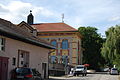
_071.JPG) Main street, view of the church |
||
| map | ||
|
||


Boudevilliers was a municipality in the Val-de-Ruz district in the canton of Neuchâtel in Switzerland . On January 1, 2013, it merged with the municipalities of Cernier , Chézard-Saint-Martin , Coffrane , Dombresson , Engollon , Fenin-Vilars-Saules , Fontainemelon , Fontaines , Les Geneveys-sur-Coffrane , Les Hauts-Geneveys , Montmollin , Le Pâquier , Savagnier and Villiers to form the new municipality of Val-de-Ruz .
geography
Boudevilliers lies at 753 m above sea level. M. , five kilometers northwest of the canton capital Neuchâtel (linear distance ). The village extends in the central part of the Val de Ruz basin in the Neuchâtel Jura .
The area of the municipal area of 12.6 km² covers a section in the central part of the syncline of the Val de Ruz. The eastern border is above the Seyon River . To the west, the area extends over the agriculturally intensively used area of the Val de Ruz and the crest of the Jura chain of the Tête de Ran . On the Rochers Bruns is at 1415 m above sea level. M. reached the highest point of the municipality. Here there are extensive Jura high pastures with the typical mighty spruce trees , which either stand individually or in groups. The municipal soil extends in a narrow corner into the Combe des Quignets , which lies in the catchment area of the Vallée des Ponts . In 1997, 6% of the municipal area was in settlements, 32% in forests and woodlands, 61% in agriculture and a little less than 1% was unproductive land.
Boudevilliers includes the hamlets of Malvilliers ( 849 m above sea level ) and La Jonchère ( 823 m above sea level ), both located on the upper western edge of the Val de Ruz, and Landeyeux ( 721 m above sea level ) in the center of the basin , as well as numerous individual farms. Neighboring municipalities to Boudevilliers are Valangin , Coffrane , Les Geneveys-sur-Coffrane , La Sagne , Les Hauts-Geneveys and Fontaines .
population
With 764 inhabitants (as of December 31, 2012), Boudevilliers is one of the smaller municipalities in the canton of Neuchâtel. 92.6% of the residents are French-speaking, 3.1% German-speaking and 1.1% Portuguese-speaking (as of 2000). Boudevilliers had 658 inhabitants in 1870; the population fell to 513 by 1900, but has been increasing again since 1950.
economy
For a long time, Boudevilliers was mainly an agricultural village. Agriculture is still very important today alongside forestry. In the 19th century there were some watchmaking companies in the village . Today the working population is employed in the local trade or works abroad, mainly in Neuchâtel or La Chaux-de-Fonds . A district hospital has been located in Landeyeux since 1872. At the beginning of the 20th century Malvilliers was a health resort with a sanatorium.
traffic
The community has good transport links. It is located on the former main road from Neuchâtel to La Chaux-de-Fonds and on the motorway-like expressway that connects these two cities. The expressway runs in the area of Boudevilliers and Malvilliers in tunnels that were built using opencast mining. Boudevilliers is connected to the public transport network by the bus line from Neuchâtel via Cernier to Villiers and a local line in Val de Ruz. From 1949 to 1969, the community was also served by the overland line 4 of the Val de Ruz trolleybus .
history
The first written mention of Boudevilliers took place in 1144 under the name Boldiwiler . Later the names Boudeviler (1195), Boldeviler (1202), Budevilliers (1413) and Budewillier (1453) appeared. The name is probably due to the personal name Balterius ( bold warrior ). In the late Middle Ages, Malvilliers was called Malavillier and Molavilliers , derived from the Latin malum ( bad ).
Boudevilliers was donated to the county of Neuchâtel in 1308 and from then on (until 1807) formed an enclave in the lordship of Valangin . In 1531 the Reformation was introduced in the village . From 1648 Neuchâtel was a principality and from 1707 it was linked to the Kingdom of Prussia through personal union. In 1806 the area was ceded to Napoleon I and came to the Swiss Confederation in the course of the Congress of Vienna in 1815 , whereby the kings of Prussia until the Neuchâtel trade in 1857 also remained princes of Neuchâtel.
Attractions
The current church of Saint-Jacques was built in the 17th century, with the apse of the previous building from the 12th century being included. From 1588 Boudevilliers belonged to the parish of Valangin.

Boudevilliers

church
school
_063.JPG)
_072.JPG)
_065.JPG)
Daughters and sons of the church
- Valère Thiébaud (* 1999), cyclist
Web links
- Official website of the municipality of Boudevilliers (French)
- Maurice Evard: Boudevilliers. In: Historical Lexicon of Switzerland .
Boudry | Les Brenets | La Brévine | Bread plamboz | Le Cerneux-Péquignot | La Chaux-de-Fonds | La Chaux-du-Milieu | Corcelles-Cormondrèche | Cornaux | Cortaillod | La Côte-aux-Fées | Cressier | Tight | La Grande Béroche | Hauterive | Le Landeron | Lignières | Le Locle | Milvignes | Neuchâtel | Peseux | Les Planchettes | Les Ponts-de-Martel | Rochefort | La Sagne | Saint-Blaise | La Tène | Valangine | Val-de-Ruz | Val-de-Travers | Les Verrières
Former municipalities: Areuse | Auvernier | Les Bayards | Bevaix | Bôle | Boudevilliers | Boveresse | Bread lingerie | Bread dessus | Buttes | Cernier | Chézard-Saint-Martin | Coffrane | Colombier | Combes | La Coudre | Couvet | Dombresson | Engollon | Epagnier | Les Eplatures | Fenin | Fenin-Vilars-Saules | Fleurier | Fontainemelon | Fontaines | Fresens | Les Geneveys-sur-Coffrane | Gorgier | Les Hauts-Geneveys | Marin | Marin-Epagnier | Montalchez | Montmollin | Môtiers | Noiraigue | Le Pâquier | Plamboz | Saint-Aubin | Saint-Aubin-Sauges | Saint-Sulpice | Suction | Saules | Savagnier | Thielle-Wavre | Thielle | Travers | Vaumarcus | Vernéaz | Vilars | Villiers | Voëns-Maley | Wavre
Canton of Neuchâtel | Municipalities of the canton of Neuchâtel