
Boudry
| Boudry | |
|---|---|
 |
|
| State : |
|
| Canton : |
|
| District : | No district division |
| BFS no. : | 6404 |
| Postal code : | 2017 |
| UN / LOCODE : | CH BDY |
| Coordinates : | 554 239 / 200211 |
| Height : | 460 m above sea level M. |
| Height range : | 429–1387 m above sea level M. |
| Area : | 16.76 km² |
| Residents: | 6154 (December 31, 2018) |
| Population density : | 367 inhabitants per km² |
| Website: | www.boudry.ch |
 Boudry |
|
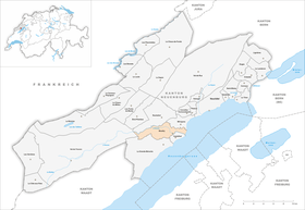
| Location of the municipality | |
  |
|
Boudry is a municipality in the canton of Neuchâtel in Switzerland .
geography
Boudry lies at 460 m above sea level. M. , eight kilometers southwest of the canton capital Neuchâtel (linear distance ). The town extends in the lower Areuse valley , near its confluence with Lake Neuchâtel , at the southern foot of the Jura .
The area of the 16.8 km² municipal area includes the lower section of the Areuse valley. In the east, the municipal soil extends in a narrow strip to Lake Neuchâtel ( Port de Boudry ) and includes the part of the flat embankment fan north of the Areuse. In the Boudry area, the Areuse and its left side stream, the Merdasson, are sunk into a marl-like slope foot plane. To the north-west of Boudry are the Gorges de l'Areuse , a deep gorge in the breakthrough valley of the Areuse through the foremost Jura range . The densely wooded, steep valley flank south of the Areuse ( Côte du Champ du Moulin and Grande Côte ) is part of the municipality . The border runs over the Montagne de Boudry , where on the Signal du Lessy with 1387 m above sea level. M. the highest point of the municipality is reached. In 1997, 11% of the municipal area was in settlements, 63% in forests and woodlands, 24% in agriculture and a little less than 2% was unproductive land.

Boudry includes the settlements of Areuse ( 446 m above sea level ) north of the Areuse at the edge of the alluvial fan, Grandchamp ( 440 m above sea level ) on the alluvial fan, Perreux ( 510 m above sea level ) at the eastern foot of the Montagne de Boudry , Trois-Rods ( 515 m above sea level ) and the lower part of Chambrelien ( 630 m above sea level ) on the southern slope of the Jura and Champ du Moulin-Dessous ( 617 m above sea level ) in the breakthrough valley of the Areuse. Neighboring municipalities of Boudry are Cortaillod , La Grande Béroche , Val-de-Travers , Rochefort and Milvignes .
population
| Population development | |
|---|---|
| year | Residents |
| 1850 | 1479 |
| 1900 | 2190 |
| 1950 | 2625 |
| 1960 | 3086 |
| 1970 | 4372 |
| 1980 | 4488 |
| 1990 | 5163 |
| 2000 | 5311 |
With 6,154 inhabitants (as of December 31, 2018), Boudry is one of the large municipalities in the canton of Neuchâtel. Of the residents, 86.5% are French-speaking, 4.2% German-speaking and 3.0% Italian-speaking (as of 2000). The population of Boudry increased significantly, especially during the 1960s and 1980s. Since 1990 only relatively small fluctuations have been observed, and since 2000 there has even been a downward trend.
politics
The voting shares of the parties in the 2015 National Council election were: FDP 29.9%, SP 24.2%, SVP 19.4%, GPS 8.9%, PdA 6.9%, glp 3.6%, CVP 3.5 %, BDP 1.6%, list du vote blanc 1.2%.
economy
Boudry was an agricultural place until the end of the 18th century , after which industrialization began. In the 18th and 19th centuries, the three Indiane factories Vauvilliers, Les Iles and Grandchamp along the Areuse were important for the entire region . After these factories were closed (most recently that of Vauvilliers in 1874), the factory buildings were used by other industries. The Community de Grandchamp has found its home on the Grandchamp factory site . Today companies in the construction industry, precision mechanics , electronics ( Cicor Technologies ), machine tool construction and a battery factory are among the most important branches of industry. Administration and tourism also have their share in the employment structure. Agriculture, which focuses on agriculture and viticulture, as well as forestry , is also of importance . There are extensive vineyards on the southern slopes of the Planeyse and along the lowest Areusetal. In Boudry there are several wine cellars, a tasting cellar and, since 1986, a wine museum. In Perreux, a cantonal hospital for the chronically ill was founded in 1894, which today houses a psychiatric clinic.
traffic
The community is very well developed in terms of transport. It is located on the main road 5 from Neuchâtel to Yverdon . A local bypass was built as early as 1960. The opening of the A5 motorway (Neuchâtel-Yverdon) in May 2005 effectively relieved the town from transit traffic . It bypasses the town in a tunnel that was created in an opencast mine.
On November 7, 1859, the Yverdon – Neuchâtel railway line was opened with a train station in Boudry on the plain between the Areuse and Merdasson valleys. Overland line 5 of the Neuchâtel tram, opened in 1892, serves two stops in Boudry and one in Areuse. The bus line that runs from Boudry to Saint-Aubin-Sauges and two local lines (Boudry - Perreux and Areuse - Cortaillod) ensure the fine distribution of public transport .
history
Boudry can look back on a very long tradition of settlement. The earliest settlement remains are the pile dwellings along the shores of Lake Neuchâtel, which were inhabited from the Neolithic to the La Tène period . Barrows from the Hallstatt period , remains of two Celtic villages, traces from Roman times , including from the Vy d'Etra trade route, and a Burgundian burial ground were also found.
The place was first mentioned in a document in 1278 under the name Baudri , which is probably due to the Burgundian personal name Buderich . Boudry and the hamlet of Pontareuse on the Areusebrücke, which was later abandoned, initially belonged to the Lords of Vaumarcus , came to the Lords of Stäffis in 1282 and to the Counts of Neuchâtel in 1313. The castle became the seat of the Boudry castle bailiwick. In the following years, the Boudry dominion often served the daughters and women of the Neuchâtel family as pawns . On September 12, 1343, the place received city rights, but with more limited rights than the city of Neuchâtel. From 1394 to 1413 Boudry belonged again to the Lords of Vaumarcus, after which the castle bailiwick was under the sovereignty of Neuchâtel until 1848. From 1648 Neuchâtel was a principality and from 1707 it was linked to the Kingdom of Prussia through personal union. In 1806 the area was ceded to Napoleon I and came to the Swiss Confederation in the course of the Congress of Vienna in 1815 , whereby the kings of Prussia until the Neuchâtel trade in 1857 also remained princes of Neuchâtel. In 1848, after the bailiwick was dissolved, Boudry became the district capital. In 1870 the Areuse settlement, which previously formed an independent community, was incorporated into Boudry.
Attractions
The little town, which is slightly elevated on a spur in the Areusetal, has a long alley and a medieval townscape with town houses from the 16th to 19th centuries. Of the former fortifications, the Tour Marfaux from 1548 and the Porte des Vermondins (rebuilt in 1741 with old building materials) are still preserved today. The oldest surviving parts of the castle to the west of the market town (mentioned in 1278) date from the 14th century. Later there were multiple conversions and additions and the last time in 1955–1957 was a comprehensive renovation. The castle now houses a viticulture and wine museum. The reformed church was built between 1645 and 1647, the facade dates from the 19th century. In front of the church is the Fountain of Justice (Fontaine de la Justice) with a statue from 1610. The Musée de lAreuse, built in 1883, is a testimony to the design of the museum when it was founded, it has hardly changed since then and mainly shows objects from archeology and ethnography. It has been a cantonal monument since 1997. The Château de Pierre , also known as the Tour de la Baconnière , was built in the 19th century. Above Boudry, the Areusetal is spanned by the eleven-arched railway bridge (1859). The Areuse Gorge is a natural attraction and is accessible via a hiking trail. The Baume du Four cave is nearby . The Pierre du Mont de Boudry (also called Bole ) is a huge erratic block that lies in the forest of Boudry (near the Bôle train station) on the forest path.
photos

Boudry Castle

Porte des Vermondis

Rue Louis Favre

Fontaine de la Justice

Memorial plaque for Philippe Suchard

Memorial plaque for Jean-Paul Marat

Obelisque Marat
Musée de l'Areuse

Neuchâtel-Boudry tram


partnership
Boudry has been in partnership with the French municipality of Voujeaucourt in Franche-Comté since 1973 .
Personalities
- Arnold Bovet (1843–1903), free church pastor and pioneer of the Blue Cross
- Jean Paul Marat (1743–1793), doctor, publisher and journalist, radical revolutionary during the French Revolution
- Léon Savary (1895–1968), Swiss writer and journalist
- Philippe Suchard (1797–1884), Swiss chocolate manufacturer and entrepreneur
Web links
- Official website of the municipality of Boudry (French)
- Germain Hausmann: Boudry. In: Historical Lexicon of Switzerland .
- Ville historique (French)
- Aerial photography
- Musée de l'Areuse
Individual evidence
- ↑ Permanent and non-permanent resident population by year, canton, district, municipality, population type and gender (permanent resident population). In: bfs. admin.ch . Federal Statistical Office (FSO), August 31, 2019, accessed on December 22, 2019 .
- ^ Election du Conseil National du October 18, 2015, Résultats des partis - Les suffrages. (aspx) (No longer available online.) Chancellerie d'État neuchâtelois, October 18, 2015, archived from the original on November 1, 2015 ; Retrieved October 30, 2016 (French). Info: The archive link was inserted automatically and has not yet been checked. Please check the original and archive link according to the instructions and then remove this notice.
Boudry | Les Brenets | La Brévine | Bread plamboz | Le Cerneux-Péquignot | La Chaux-de-Fonds | La Chaux-du-Milieu | Corcelles-Cormondrèche | Cornaux | Cortaillod | La Côte-aux-Fées | Cressier | Tight | La Grande Béroche | Hauterive | Le Landeron | Lignières | Le Locle | Milvignes | Neuchâtel | Peseux | Les Planchettes | Les Ponts-de-Martel | Rochefort | La Sagne | Saint-Blaise | La Tène | Valangine | Val-de-Ruz | Val-de-Travers | Les Verrières
Former municipalities: Areuse | Auvernier | Les Bayards | Bevaix | Bôle | Boudevilliers | Boveresse | Bread lingerie | Bread dessus | Buttes | Cernier | Chézard-Saint-Martin | Coffrane | Colombier | Combes | La Coudre | Couvet | Dombresson | Engollon | Epagnier | Les Eplatures | Fenin | Fenin-Vilars-Saules | Fleurier | Fontainemelon | Fontaines | Fresens | Les Geneveys-sur-Coffrane | Gorgier | Les Hauts-Geneveys | Marin | Marin-Epagnier | Montalchez | Montmollin | Môtiers | Noiraigue | Le Pâquier | Plamboz | Saint-Aubin | Saint-Aubin-Sauges | Saint-Sulpice | Suction | Saules | Savagnier | Thielle-Wavre | Thielle | Travers | Vaumarcus | Vernéaz | Vilars | Villiers | Voëns-Maley | Wavre
Canton of Neuchâtel | Municipalities of the canton of Neuchâtel