
Narrow
| Narrow | |
|---|---|
 |
|
| State : |
|
| Canton : |
|
| District : | No district division |
| BFS no. : | 6453 |
| Postal code : | 2073 |
| Coordinates : | 567 626 / 212012 |
| Height : | 816 m above sea level M. |
| Height range : | 728–1274 m above sea level M. |
| Area : | 9.58 km² |
| Residents: | 272 (December 31, 2018) |
| Population density : | 28 inhabitants per km² |
| Website: | www.enges.ch |
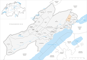
| Location of the municipality | |
  |
|
Enges is a municipality in the canton of Neuchâtel in Switzerland .
geography
Enges is 816 m above sea level. M. , 9 km northeast of the canton capital Neuchâtel (linear distance). The village extends on a ledge and in a south-facing depression on the southern slopes of the Jura , in a panoramic position high above the plains of the Swiss plateau .
The area of the 9.6 km² municipal area comprises a section of the southern slope of the Jura with the lordel hollow between the Chasseral chain and the height of Serroue . In the northwest and north, the municipality extends over the wooded slopes of the Jura ( Forêt de Pourtalès ) to the ridge of the foremost Jura chain . On the Grand Chaumont is at 1270 m above sea level. M. reached the highest point of the municipality. Here there are extensive Jura high pastures with the typical mighty spruce trees , which either stand individually or in groups. In 1997, 2% of the municipal area was accounted for by settlements, 53% for forests and woodlands and 45% for agriculture.
The new residential district Brisecou east of the village, the hamlet of Lordel , 912 m above sea level, belongs to Enges . M. in a hollow between Grand Chaumont and Serroue, and some individual farms. Neighboring municipalities of Enges are Lignières , Le Landeron , Cressier , Neuchâtel and Val-de-Ruz .
population
With 272 inhabitants (as of December 31, 2018) Enges is one of the small communities in the canton of Neuchâtel. 88.6% of the residents are French-speaking, 8.7% German-speaking and 1.4% English-speaking (as of 2000). The population decreased from 1900 (then 204 inhabitants) to 1950 (143 inhabitants), but has increased significantly since around 1980.
politics
The voting shares of the parties in the 2015 National Council election were: FDP 33.2%, SVP 19.9%, SP 18.5%, GPS 10.3%, glp 9.2%, PdA 3.9%, CVP 2.5 %, BDP 0.5%.
The mayor is Claude Gisiger (as of 2017).
economy
Up until the beginning of the 1980s, Enges was mainly an agricultural village, after which it has developed into a residential community. Since there are only a few jobs in the village outside the primary sector, many employed people are commuters who work in the Neuchâtel region.
traffic
The community is located off the main thoroughfares on a cantonal road that leads from Saint-Blaise to Nods . Enges is linked to the public transport network by the Postbus course that runs from Saint-Blaise to Lignières.
history
The area of Enges was settled very early, which is attested by grave finds from the Hallstatt period near Lordel. During the Roman era , the Vy d'Etra, a partly paved road from Neuchâtel via the Montagne de Diesse to the Pierre Pertuis , led through today's town.
The village was first mentioned in writing in 1178 under the name en Enge , which belonged to the Saint-Imier chapter . In 1182, the notation appears, and in 1212, comes . The place had belonged to the county of Neuchâtel since the 14th century and was part of the Le Landeron castle bailiwick. Like the mother parish of Cressier, Enges stayed with the Catholic faith during the Reformation . From 1648 Neuchâtel was a principality and from 1707 it was linked to the Kingdom of Prussia through a personal union. In 1806 the area was ceded to Napoleon I and came to the Swiss Confederation in the course of the Congress of Vienna in 1815 , whereby the kings of Prussia until the Neuchâtel trade in 1857 also remained princes of Neuchâtel. In 1856 seven houses and the chapel fell victim to a village fire.
Attractions

The Notre Dame des Anges chapel was consecrated in 1678. It was rebuilt after the village fire and renovated for the last time in 1977. Some old farmhouses from the 18th and 19th centuries have been preserved in the town center.
Web links
- Official website of the municipality of Enges
- Olivier Girardbille: Tight . In: Historical Lexicon of Switzerland .
Individual evidence
- ↑ Permanent and non-permanent resident population by year, canton, district, municipality, population type and gender (permanent resident population). In: bfs. admin.ch . Federal Statistical Office (FSO), August 31, 2019, accessed on December 22, 2019 .
- ^ Election du Conseil National du October 18, 2015, Résultats des partis - Les suffrages. (aspx) (No longer available online.) Chancellerie d'État neuchâtelois, October 18, 2015, archived from the original on November 1, 2015 ; Retrieved October 30, 2016 (French). Info: The archive link was inserted automatically and has not yet been checked. Please check the original and archive link according to the instructions and then remove this notice.
Boudry | Les Brenets | La Brévine | Bread plamboz | Le Cerneux-Péquignot | La Chaux-de-Fonds | La Chaux-du-Milieu | Corcelles-Cormondrèche | Cornaux | Cortaillod | La Côte-aux-Fées | Cressier | Tight | La Grande Béroche | Hauterive | Le Landeron | Lignières | Le Locle | Milvignes | Neuchâtel | Peseux | Les Planchettes | Les Ponts-de-Martel | Rochefort | La Sagne | Saint-Blaise | La Tène | Valangine | Val-de-Ruz | Val-de-Travers | Les Verrières
Former municipalities: Areuse | Auvernier | Les Bayards | Bevaix | Bôle | Boudevilliers | Boveresse | Bread lingerie | Bread dessus | Buttes | Cernier | Chézard-Saint-Martin | Coffrane | Colombier | Combes | La Coudre | Couvet | Dombresson | Engollon | Epagnier | Les Eplatures | Fenin | Fenin-Vilars-Saules | Fleurier | Fontainemelon | Fontaines | Fresens | Les Geneveys-sur-Coffrane | Gorgier | Les Hauts-Geneveys | Marin | Marin-Epagnier | Montalchez | Montmollin | Môtiers | Noiraigue | Le Pâquier | Plamboz | Saint-Aubin | Saint-Aubin-Sauges | Saint-Sulpice | Suction | Saules | Savagnier | Thielle-Wavre | Thielle | Travers | Vaumarcus | Vernéaz | Vilars | Villiers | Voëns-Maley | Wavre
Canton of Neuchâtel | Municipalities of the canton of Neuchâtel