
Les Ponts-de-Martel
| Les Ponts-de-Martel | |
|---|---|
 |
|
| State : |
|
| Canton : |
|
| District : | No district division |
| BFS no. : | 6437 |
| Postal code : | 2316 |
| Coordinates : | 546359 / 205681 |
| Height : | 1009 m above sea level M. |
| Height range : | 979–1337 m above sea level M. |
| Area : | 18.17 km² |
| Residents: | 1248 (December 31, 2018) |
| Population density : | 69 inhabitants per km² |
| Website: | www.lesponts-de-martel.ch |
 |
|
| Location of the municipality | |
  |
|
Les Ponts-de-Martel is a municipality in the canton of Neuchâtel in Switzerland .
geography
Les Ponts-de-Martel is located at 1009 m above sea level. M. , 16 km west of the canton capital Neuchâtel (linear distance). The village extends on the western edge of the high valley Vallée des Ponts in the Neuchâtel Jura and on the adjacent slope of the anticlines of the Grand Som Martel .
The area of the 18.2 km² municipal area includes the western part of the here flat Vallée des Ponts with its boggy areas, especially in the area of the Bois des Lattes . The eastern border is formed by the Le Bied creek , which disappears into an infiltration funnel on the southern edge of the village. To the west, the parish extends to the anticline that separates the Vallée des Ponts from the Vallée de la Brévine . In a narrow corner in the far west, the area extends over the Combes Dernier valley to the Haut des Joux ( 1275 m above sea level ). In the north, Les Ponts-de-Martel includes the summit of the Grand Som Martel, on which at 1337 m above sea level. M. the highest point of the municipality is reached. Here there are extensive Jura high pastures with the typical mighty spruce trees , which either stand individually or in groups. In 1997, 6% of the municipal area was in settlements, 31% in forests and woodlands, 59% in agriculture and around 4% was unproductive land.
Les Ponts-de-Martel includes the hamlets Martel-Dernier ( 1016 m above sea level ), Le Voisinage ( 1001 m above sea level ) and Petit Martel ( 1008 m above sea level ), all on the western edge of the Vallée des Ponts, as well as numerous farm settlements and individual farms scattered across the Jura heights. Neighboring communities to Les Ponts-de-Martel are Le Locle , La Chaux-du-Milieu , La Brévine , Val-de-Travers , Brot-Plamboz and La Sagne .

population
| Population development | |
|---|---|
| year | Residents |
| 1850 | 1687 |
| 1870 | 2189 |
| 1900 | 1957 |
| 1950 | 1508 |
| 1960 | 1429 |
| 1970 | 1327 |
| 1980 | 1183 |
| 1990 | 1192 |
| 2000 | 1297 |
With 1248 inhabitants (as of December 31, 2018), Les Ponts-de-Martel is one of the medium-sized communities in the canton of Neuchâtel. 93.7% of the residents are French-speaking, 3.6% German-speaking and 0.5% speak Albanian (as of 2000). After the peak around 1870 with around 2200 inhabitants, the population of Les Ponts-de-Martel decreased by almost 50% due to strong emigration until around 1980; since then there has been a slight increase again.
politics
The voting shares of the parties in the 2015 National Council election were: SVP 29.7%, SP 29.1%, FDP 23.1%, PdA 7.8%, GPS 4.8%, CVP 2.6%, list du vote blanc 1.1%, glp 0.9%, BDP 0.2%.
economy

.jpg)
Les Ponts-de-Martel is the regional center of the Vallée des Ponts. For a long time the village was mainly characterized by agriculture . The industrialization of the valley began at the end of the 18th century , with spinning and lace making being introduced first, mainly done at home. Watchmaking gained a foothold after 1800 and led to a great economic boom in Les Ponts-de-Martel. Another important branch of business since the 18th century was peat cutting in the extensive moorland areas of the high valley. Peat was a popular commercial product, especially during the two world wars. Today the construction of agricultural machines, the construction industry, clock making and meat processing are among the main branches of business. Agriculture also still plays an important role, with livestock and dairy farming predominating. There is also a cheese dairy.
traffic
The municipality is located on the cantonal road from Neuchâtel over the La Tourne pass to Le Locle. Les Ponts-de-Martel is the end point of the meter-gauge railway line of the former Ponts – Sagne – Chaux-de-Fonds (PSC), which has been operated by the Transports Régionaux Neuchâtelois (TRN) since 1999 . The railway line, opened on July 26, 1889, connects the Vallée des Ponts with La Chaux-de-Fonds ; another three stops on the railway line are in the street-line village of Petit-Martel. In addition, Les Ponts-de-Martel is served by the Postbus course from Neuchâtel to Le Locle.
tourism
The region around Les Ponts-de-Martel and the Vallée des Ponts with the Bois des Lattes nature reserve are popular excursion destinations. In winter, the flat high valley and the adjacent Jura heights are ideal for cross-country skiing .
history
The Vallée des Ponts was settled by emigrants from the canton of Vaud in the 14th century after the Lords of Valangin had assured them that they would be largely exempt from taxes. The place name Les Ponts-de-Martel has nothing to do with bridges in the strict sense of the word, but rather points to the wooden paths and footbridges that had to be built to cross the moorland. Martel is a dialect word for marais ( moor ).
The area of Les Ponts-de-Martel was under the sovereignty of the county of Neuchâtel. From 1648 Neuchâtel was a principality and from 1707 it was linked to the Kingdom of Prussia through a personal union. In 1806 the area was ceded to Napoleon I and came to the Swiss Confederation in the course of the Congress of Vienna in 1815 , whereby the kings of Prussia until the Neuchâtel trade in 1857 also remained princes of Neuchâtel.
Daughters and sons of the church
- Arnold Grandjean (1890–1961), racing cyclist and entrepreneur
Attractions
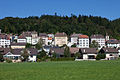
Les Ponts-de-Martel shows the typical appearance of a village formerly shaped by the watch industry. It has a chessboard-like floor plan with streets parallel to the slope and short, steep cross connections. The cubic multi-storey apartment buildings date from the end of the 19th and beginning of the 20th century. The current parish church was built in 1844.
photos
Les Ponts-de-Martel

Grande Rue, Center

Temple

Rue de la Promenade

High moor (Tourbière)

High moor (Tourbière)


Web links
- Official website of the municipality of Les Ponts-de-Martel (French)
- Germain Hausmann: Ponts-de-Martel, Les. In: Historical Lexicon of Switzerland .
Individual evidence
- ↑ Permanent and non-permanent resident population by year, canton, district, municipality, population type and gender (permanent resident population). In: bfs. admin.ch . Federal Statistical Office (FSO), August 31, 2019, accessed on December 22, 2019 .
- ^ Election du Conseil National du October 18, 2015, Résultats des partis - Les suffrages. (aspx) (No longer available online.) Chancellerie d'État neuchâtelois, October 18, 2015, archived from the original on November 1, 2015 ; Retrieved October 30, 2016 (French). Info: The archive link was inserted automatically and has not yet been checked. Please check the original and archive link according to the instructions and then remove this notice.
Boudry | Les Brenets | La Brévine | Bread plamboz | Le Cerneux-Péquignot | La Chaux-de-Fonds | La Chaux-du-Milieu | Corcelles-Cormondrèche | Cornaux | Cortaillod | La Côte-aux-Fées | Cressier | Tight | La Grande Béroche | Hauterive | Le Landeron | Lignières | Le Locle | Milvignes | Neuchâtel | Peseux | Les Planchettes | Les Ponts-de-Martel | Rochefort | La Sagne | Saint-Blaise | La Tène | Valangine | Val-de-Ruz | Val-de-Travers | Les Verrières
Former municipalities: Areuse | Auvernier | Les Bayards | Bevaix | Bôle | Boudevilliers | Boveresse | Bread lingerie | Bread dessus | Buttes | Cernier | Chézard-Saint-Martin | Coffrane | Colombier | Combes | La Coudre | Couvet | Dombresson | Engollon | Epagnier | Les Eplatures | Fenin | Fenin-Vilars-Saules | Fleurier | Fontainemelon | Fontaines | Fresens | Les Geneveys-sur-Coffrane | Gorgier | Les Hauts-Geneveys | Marin | Marin-Epagnier | Montalchez | Montmollin | Môtiers | Noiraigue | Le Pâquier | Plamboz | Saint-Aubin | Saint-Aubin-Sauges | Saint-Sulpice | Suction | Saules | Savagnier | Thielle-Wavre | Thielle | Travers | Vaumarcus | Vernéaz | Vilars | Villiers | Voëns-Maley | Wavre
Canton of Neuchâtel | Municipalities of the canton of Neuchâtel