
Rochefort NE
| NE is the abbreviation for the canton of Neuchâtel in Switzerland and is used to avoid confusion with other entries of the name Rochefort . |
| Rochefort | |
|---|---|
 |
|
| State : |
|
| Canton : |
|
| District : | No district division |
| BFS no. : | 6413 |
| Postal code : | 2019 2149 bread lingerie |
| Coordinates : | 552.15 thousand / 203 316 |
| Height : | 759 m above sea level M. |
| Height range : | 523–1390 m above sea level M. |
| Area : | 25.85 km² |
| Residents: | 1239 (December 31, 2018) |
| Population density : | 48 inhabitants per km² |
| Website: | www.rochefort.ch |
 Rochefort |
|
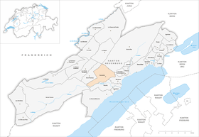
| Location of the municipality | |
  |
|
Rochefort is a municipality in the canton of Neuchâtel in Switzerland .
geography
Rochefort lies at 759 m above sea level. M. , 9 km west of the canton capital Neuchâtel (linear distance). The community extends in a hollow in the catchment area of the Merdasson brook on the southern slope of the Jura , at the entrance to the Val de Travers , in a panoramic position high above Lake Neuchâtel .
The area of the 20.9 km² municipal area includes the basin of Rochefort and the slightly deepened valley of the Merdasson. It extends east to the forest height of Les Pommerets ( 868 m above sea level ), to the southeast in the Plan du Bois and south to the forest of Chassagne . The southern border is temporarily formed by the Areuse , which has here created a deep breakthrough valley through erosion through the foremost Jura range . In the west the height of Tablettes rises ( 1288 m above sea level ). To the north, the municipality extends over the deeply cut dry valley Mauvaise Combe to the moorland Sagneule on the anticline of Mont Racine . The highest point of Rochefort is 1390 m above sea level. M. at the height of the Mont-Racine chain. In the north and north-west in the area of the La Tourne pass there are extensive Jura high pastures with the typical mighty spruce trees , which either stand individually or in groups. In 1997, 4% of the municipal area was in settlements, 62% in forests and woodlands, 33% in agriculture and a little less than 1% was unproductive land.
Rochefort includes the settlements of Chambrelien ( 630 m above sea level ) on the slope below the village, Montézillon ( 758 m above sea level ) on the southern slope of Les Pommerets, Les Grattes de Vent ( 835 m above sea level ) and Les Grattes de Bise ( 840 m above sea level ) on the southern slope of the Mont Racine chain above the village, La Tourne ( 1129 m above sea level ) on the pass of the same name and numerous individual farms. Neighboring municipalities to Rochefort are Boudry , Brot-Plamboz , La Sagne , Val-de-Ruz , Val-de-Travers , Corcelles-Cormondrèche and Milvignes .

population
With 1239 inhabitants (as of December 31, 2018) Rochefort is one of the medium-sized municipalities in the canton of Neuchâtel. 87.7% of the residents are French-speaking, 5.4% German-speaking and 1.4% English-speaking (as of 2000). In 1950 Rochefort had 517 inhabitants; since about 1970 the population has almost doubled.
politics
The voting shares of the parties in the 2015 National Council election were: FDP 31.1%, SP 21.4%, SVP 19.0%, GPS 13.3%, PdA 5.5%, glp 4.4%, CVP 3.2 %, BDP 1.4%.
economy
Rochefort was mainly an agricultural village until the middle of the 20th century . Even today arable farming in the lower part of the municipality and cattle and dairy farming on the Jura Heights play a certain role. There are other jobs in a precision engineering company as well as in local small businesses. In the last few decades Rochefort has developed into a residential community. Many workers are commuters who work in the Neuchâtel region.
traffic
The community has good transport links. It is located on the main road from Neuchâtel into the Val de Travers and further over the border crossing from Les Verrières to Pontarlier in France . This traffic axis is crossed at Rochefort by the road that leads from Colombier over the La Tourne pass to Les Ponts-de-Martel . On December 1, 1859, the Neuchâtel – La Chaux-de-Fonds line was inaugurated. The switchback station Chambrelien is located west of the settlement of that name. The bus route from Colombier via Rochefort to Les Grattes de Bise ensures the fine distribution of public transport.
history
In 1867, the Cotencher cave, used in prehistoric times, was discovered in the municipality . Excavations from 1916 to 1918 uncovered both cave bear bones and stone tools that were used during the period of the Moustérien culture. The upper jaw of a Neanderthal man was discovered in 1964.
Rochefort, mentioned in 1184 as Rupeforti , has been the seat of the Kastlanei of the same name since that time. This was since the 14th century under the sovereignty of the Counts of Neuchâtel. From 1648 Neuchâtel was a principality and from 1707 it was linked to the Kingdom of Prussia through personal union. In 1806 the area was ceded to Napoleon I and came to the Swiss Confederation in the course of the Congress of Vienna in 1815 , whereby the kings of Prussia until the Neuchâtel trade in 1857 also remained princes of Neuchâtel.
The Béguin and Renaud family has been recorded in Rochefort in Les Grattes since 1452. It is the hometown of the Béguin family. 14 generations are genealogically proven until 2012. Her coat of arms represents 2 lions with a sloping ribbon with three roses. The government councilor Jacques Béguin from le Crêt du Locle also belonged to this family.
Attractions
The Reformed Church of Rochefort was built in 1755. At the entrance to the narrow breakthrough valley of the Areuse are the ruins of the former Rochefort castle, which once controlled traffic in the Val de Travers . However, the castle was no longer inhabited by the 16th century.
Web links
- Official website of the municipality of Rochefort (French)
- Germain Hausmann: Rochefort NE. In: Historical Lexicon of Switzerland .
Individual evidence
- ↑ Permanent and non-permanent resident population by year, canton, district, municipality, population type and gender (permanent resident population). In: bfs. admin.ch . Federal Statistical Office (FSO), August 31, 2019, accessed on December 22, 2019 .
- ^ Election du Conseil National du October 18, 2015, Résultats des partis - Les suffrages. (aspx) (No longer available online.) Chancellerie d'État neuchâtelois, October 18, 2015, archived from the original on November 1, 2015 ; Retrieved October 30, 2016 (French). Info: The archive link was inserted automatically and has not yet been checked. Please check the original and archive link according to the instructions and then remove this notice.
Boudry | Les Brenets | La Brévine | Bread plamboz | Le Cerneux-Péquignot | La Chaux-de-Fonds | La Chaux-du-Milieu | Corcelles-Cormondrèche | Cornaux | Cortaillod | La Côte-aux-Fées | Cressier | Tight | La Grande Béroche | Hauterive | Le Landeron | Lignières | Le Locle | Milvignes | Neuchâtel | Peseux | Les Planchettes | Les Ponts-de-Martel | Rochefort | La Sagne | Saint-Blaise | La Tène | Valangine | Val-de-Ruz | Val-de-Travers | Les Verrières
Former municipalities: Areuse | Auvernier | Les Bayards | Bevaix | Bôle | Boudevilliers | Boveresse | Bread lingerie | Bread dessus | Buttes | Cernier | Chézard-Saint-Martin | Coffrane | Colombier | Combes | La Coudre | Couvet | Dombresson | Engollon | Epagnier | Les Eplatures | Fenin | Fenin-Vilars-Saules | Fleurier | Fontainemelon | Fontaines | Fresens | Les Geneveys-sur-Coffrane | Gorgier | Les Hauts-Geneveys | Marin | Marin-Epagnier | Montalchez | Montmollin | Môtiers | Noiraigue | Le Pâquier | Plamboz | Saint-Aubin | Saint-Aubin-Sauges | Saint-Sulpice | Suction | Saules | Savagnier | Thielle-Wavre | Thielle | Travers | Vaumarcus | Vernéaz | Vilars | Villiers | Voëns-Maley | Wavre
Canton of Neuchâtel | Municipalities of the canton of Neuchâtel