
Neuchâtel – Le Locle-Col-des-Roches railway line
| Neuchâtel – Le Locle | |||||||||||||||||||||||||||||||||||||||||||||||||||||||||||||||||||||||||||||||||||||||||||||||||||||||||||||||||||||||||||||||||||||||||||||||||||||||||
|---|---|---|---|---|---|---|---|---|---|---|---|---|---|---|---|---|---|---|---|---|---|---|---|---|---|---|---|---|---|---|---|---|---|---|---|---|---|---|---|---|---|---|---|---|---|---|---|---|---|---|---|---|---|---|---|---|---|---|---|---|---|---|---|---|---|---|---|---|---|---|---|---|---|---|---|---|---|---|---|---|---|---|---|---|---|---|---|---|---|---|---|---|---|---|---|---|---|---|---|---|---|---|---|---|---|---|---|---|---|---|---|---|---|---|---|---|---|---|---|---|---|---|---|---|---|---|---|---|---|---|---|---|---|---|---|---|---|---|---|---|---|---|---|---|---|---|---|---|---|---|---|---|---|
.jpg) NPZ at Le Locle train station
| |||||||||||||||||||||||||||||||||||||||||||||||||||||||||||||||||||||||||||||||||||||||||||||||||||||||||||||||||||||||||||||||||||||||||||||||||||||||||
| Timetable field : | 223 | ||||||||||||||||||||||||||||||||||||||||||||||||||||||||||||||||||||||||||||||||||||||||||||||||||||||||||||||||||||||||||||||||||||||||||||||||||||||||
| Route length: | 38.21 km | ||||||||||||||||||||||||||||||||||||||||||||||||||||||||||||||||||||||||||||||||||||||||||||||||||||||||||||||||||||||||||||||||||||||||||||||||||||||||
| Gauge : | 1435 mm ( standard gauge ) | ||||||||||||||||||||||||||||||||||||||||||||||||||||||||||||||||||||||||||||||||||||||||||||||||||||||||||||||||||||||||||||||||||||||||||||||||||||||||
| Power system : | 15 kV 16.7 Hz ~ | ||||||||||||||||||||||||||||||||||||||||||||||||||||||||||||||||||||||||||||||||||||||||||||||||||||||||||||||||||||||||||||||||||||||||||||||||||||||||
| Maximum slope : | 31 ‰ | ||||||||||||||||||||||||||||||||||||||||||||||||||||||||||||||||||||||||||||||||||||||||||||||||||||||||||||||||||||||||||||||||||||||||||||||||||||||||
|
|||||||||||||||||||||||||||||||||||||||||||||||||||||||||||||||||||||||||||||||||||||||||||||||||||||||||||||||||||||||||||||||||||||||||||||||||||||||||
The Neuchâtel – Le Locle-Col-des-Roches line is a single - track, standard - gauge railway line operated by the Swiss Federal Railways (SBB).
history


The railway line from Neuchâtel to La Chaux-de-Fonds and on to Le Locle was built in four stages between 1857 and 1860 by the Jura industriel (JI). The JI was taken over by the Jura bernois (JB) in 1875 , which changed its name to Jura – Bern – Lucerne Railway (JBL) in 1884. The JBL extended the railway to the Swiss-French border at Le Locle-Col-des-Roches (then Brenets-Col-des-Roches) and connected it through the Col-des-Roches tunnel via Besançon to the French railway network of the Paris company -Lyon-Méditerrané (PLM).
On January 1, 1886, the 38.21 kilometer long Neuchâtel – Le Locle-Col-des-Roches line was outsourced from the Jura-Bern-Lucerne Railway (JBL) and integrated into the newly founded Jura neuchâtelois (JN), which served the Canton Neuchâtel belonged.
The federal government bought the railway from the canton of Neuchâtel and incorporated it into the network of the Swiss Federal Railways (SBB) on July 1, 1913 . In 1931, the SBB electrified the line to Le Locle- Col-des-Roches with 15 kV 16⅔ Hz alternating current. The subsequent French line is not electrified.
Route description
Shortly after the Neuchâtel train station , the line to Le Locle separates from the main line to Lausanne and, after a short tunnel, comes to the Les Deurres stop and Corcelles - Peseux train station . The trains continue to gain height quickly and travelers can enjoy the panorama over Lake Neuchâtel . In the station Chambrelien one is hairpin necessary so that trains can continue on their way. Since the SBB only use shuttle trains on this route , it is no longer necessary to change the locomotive. After the change of direction, the trains gain height and travel to Les Geneveys-sur-Coffrane . After the larger town of Les Hauts-Geneveys, trains pass through the Loges and Mont-Sagne tunnels. After the second tunnel, the track is parallel to the narrow-gauge line from Les Ponts-de-Martel . Shortly before La Chaux-de-Fonds, the lines from Neuchâtel and Biel / Bienne run together through a tunnel to the station.
On the 8-kilometer stretch between La-Chaux-de-Fonds and Le Locle, there used to be several stops that have been closed over time. However, the Le Crêt-du-Locle stop was put back into operation in August 2007. Most trains from La Chaux-de-Fonds end in Le Locle, where the narrow-gauge TRN enables the onward journey to Les Brenets . The few railcars that continue to France arrive at Le Locle-Col-des-Roches station after a steep incline and crossing a steel bridge. There you drive into the Col-des-Roches tunnel, in the middle of which is the national border.
Transrun
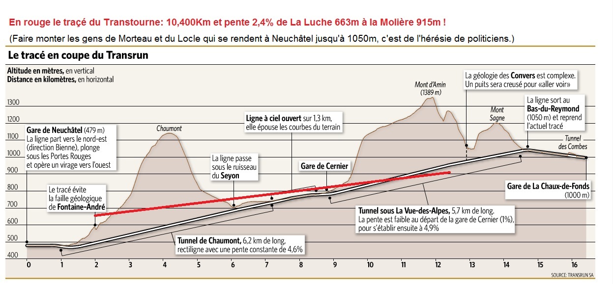
On September 23, 2012, the Neuchâtel voters narrowly rejected the so-called “Transrun”, a direct S-Bahn connection between Neuchâtel and La Chaux-de-Fonds. The railway line, which cost around one billion francs, would have made the cumbersome hairpin in Chambrelien superfluous, shortened the route from 29.5 to 16.7 kilometers and cut the journey time by half from 27 minutes. This would have required the construction of a 6.2 km long tunnel through the Chaumont and a 5.7 km long cut under the Vue des Alpes . In the open section in between, the trains would have crossed at Cernier station .
business

Since December 13, 2015, a RegioExpress and a regional train have been running between Neuchâtel and La Chaux-de-Fonds every hour , serving the Corcelles-Peseux, Chambrelien and Les Geneveys-sur-Coffrane stations every half hour. The RE trains are linked from Bern to La Chaux-de-Fonds. There are EW III -Pendelzüge the BLS with locomotives of the series Re 465 used. The regional trains continue to Le Locle via La Chaux-de-Fonds.
The offer is supplemented by a second hourly regional train connection between La Chaux-de-Fonds and Le Locle. The stops in the lower section of the route are served by the Neuchâtel - Corcelles-Peseux regios that run every half hour. This offer results in three-hour motor vehicle rotations Neuchâtel - Le Locle - La Chaux-de-Fonds - Le Locle - Neuchâtel - Corcelles-Peseux - Neuchâtel - Corcelles-Peseux - Neuchâtel. Two RABe 524 ( TILO - Flirt ) multiple units of the SBB and a RABe 527 of the Neuchâtel transport company transN are used .
Between La Chaux-de-Fonds and Morteau there are also several diesel-powered trains for cross-border commuters (4 trains per day from La Chaux-de-Fonds, 6 in the opposite direction), which also use the border station Le Locle-Col -des-Roches serve. The Franche-Comté region has purchased type X 73500 railcars to operate this route . Four of them, X 73752 to 73755, have been equipped with the Swiss Signum train protection system since 2010 , but without ZUB and ETM .
literature
- Hans G. Wägli: Swiss rail network and Swiss rail profile CH +. AS Verlag, Zurich 2010, ISBN 978-3-909111-74-9 .
- Pascal Siegfried: International railway lines in the Jura. (PDF 3.2 MB) September 25, 2007, accessed April 2, 2014 .
References and comments
- ↑ Abbreviation from Transport entre Régions Urbaines Neuchâteloises German, for example, traffic between the urban regions of Neuchâtel
- ↑ Andrea Kucera: Narrow no to the Transrun underground rapid transit system. In: NZZ Online. September 23, 2012, accessed April 16, 2014 .
- ↑ Le tracé en coupe du Transrun. Transrun SA, accessed April 16, 2014 (French).
- ↑ As of the 2014 timetable
- ^ Neuchâtel region. Timetables. SBB, accessed on April 18, 2014 .