
Pontarlier
| Pontarlier | ||
|---|---|---|

|
|
|
| region | Bourgogne-Franche-Comté | |
| Department | Doubs | |
| Arrondissement | Pontarlier | |
| Canton | Pontarlier | |
| Community association | Grand Pontarlier | |
| Coordinates | 46 ° 54 ' N , 6 ° 21' E | |
| height | 811-1,320 m | |
| surface | 41.35 km 2 | |
| Residents | 17,197 (January 1, 2017) | |
| Population density | 416 inhabitants / km 2 | |
| Post Code | 25300 | |
| INSEE code | 25462 | |
| Website | www.ville-pontarlier.fr | |
 View of Pontarlier |
||

Pontarlier ( German outdated Bünterlin, Latin Ariolica ) is a town with 17,197 inhabitants (as of January 1, 2017) in the French Jura not far from the Swiss border. It belongs to the Doubs department in the Bourgogne-Franche-Comté region and is the seat of a sub-prefecture . The city is a member and seat of the Grand Pontarlier municipal association . The inhabitants of the city are referred to in French as pontissaliens .
geography
Pontarlier is located about 20 kilometers from the border with Switzerland on a plateau on the upper reaches of the Doubs and, with an altitude of 837 m, is the second highest city in France after Briançon . Besançon , seat of the prefecture , is about 60 km northwest of the city. The municipality is located north of the Upper Jura Regional Nature Park , with which it is associated as an official access point.
history
Thanks to its geographical location, the city played an important role in the exchange of goods between northern and southern Europe from an early age, and in the 12th century it became a trading center.
The city has suffered numerous border invasions throughout history. She also experienced severe fires, which were due to the necessary heating in the harsh winter months.
Pontarlier was the 19th century capital of absinthe production in 1805 was of Henri-Louis Pernod , the first absinthe - distillery opened. With the absinthe ban in 1914, this branch of industry no longer played a role until the Pernot Fils distillery started production again in 2001.
| Population development | ||||||||||||
|---|---|---|---|---|---|---|---|---|---|---|---|---|
| year | 1793 | 1851 | 1896 | 1954 | 1962 | 1968 | 1975 | 1982 | 1990 | 1999 | 2008 | 2016 |
| Residents | 3,348 | 4,953 | 7,557 | 13,786 | 15,382 | 16,442 | 17,983 | 17,781 | 18,104 | 18,360 | 18,639 | 17,284 |
Attractions
- The Porte Saint-Pierre was built in 1772 on the site of the former Porte du Boulevard . The Porte du Boulevard was the most important of the five city gates of Pontarlier.
- Church Saint-Bénigne 17th century
- Chapelle des Annonciades (18th century)
- Chapelle de l'Espérance (1861)
- Barracks Marguet (1748–1764)
- City Museum of Pontarlier on Place d'Arçon
- Espera Museum by Franco Sbarro (automotive design)
- The Château de Joux (built in the 10th century, expanded in its current form in the 18th century) a few kilometers south of Pontarlier. From the 18th century it served as a prison and housed Mirabeau , Toussaint-Louverture and Kleist , among others . The fortress can now be visited in half-hourly guided tours and houses a small museum with military implements of the French army from the 18th century.

Porte Saint-Pierre

Church Saint-Bénigne
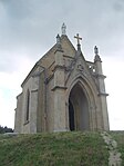
Chapelle de l'Espérance
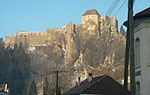
Château de Joux


tourism
Pontarlier is a winter sports resort , mainly cross-country skiing is practiced there. Due to the proximity of the Doubs river and the two lakes Lac de Saint-Point (the third largest natural lake in France) and Lac de Remoray, there is also a wide range of water sports.
Sports
In 1997 Pontarlier was named the sportiest city in France among cities with less than 30,000 inhabitants. A relatively large number of well-known winter sports enthusiasts were born here (see below). The city was a stage destination of the Tour de France several times ( 2009 , 2001 , 1985 , 1972 , 1960 , 1928 , 1927 ).
traffic
Pontarlier station is located on the international Neuchâtel – Pontarlier railway line and was served by a pair of TGV trains from the French-Swiss railway company Lyria , which operated on the Paris - Bern line , from 1987 to 2013 . Today there are connections of the regional transport company TER Franche-Comté of the SNCF to Dole , Dijon , Frasne (with TGV connection to Paris) and to Neuchâtel .
Local public transport in the city is provided by the Pontabus bus network .
Pontarlier Airport ( ICAO code : LFSP) is located about two kilometers west of the city. The Aéroclub Pontarlier, located there, was founded in 1930.
absinthe
The importance of absinthe production is shown in a private museum set up by the Pierre Guy distillery, in which absinthe is also tasted. The distillery contributed in a curious way to the elucidation of a geological fact: in 1901 a fire destroyed the factory; over 1 million liters of absinthe flowed into the nearby Doubs river . Amazingly, the water in the source of the Loue , which is about 15 km away, took on the smell and color of diluted absinthe. Since then, people have known about the underground connection between the two bodies of water. Something similar has also been found in Germany on the Swabian Alb ( Danube sinking ), but using the fluorescent dyes fluorescein and eosin .
Town twinning
Pontarlier is linked to through town twinning
- Villingen-Schwenningen , Germany , since 1964
- Zarautz , Spain , since 1994
- Yverdon-les-Bains , Switzerland , since 2003
Personalities
- Célia Aymonier (* 1991), biathlete and cross-country skier
- Florence Baverel-Robert (* 1974), former biathlete
- Pierre Bichet , painter, still residing in Pontarlier
- François Braud (* 1986), former Nordic combined skier
- Caroline Colombo (* 1996), biathlete
- Vincent Defrasne (born 1977), biathlete
- Edgar Faure (1908–1988), Maire 1971–1977
- Philippe Grenier (1865–1944), doctor and MP
- Fabrice Guy (* 1968), former Nordic combined skier
- Arnaud Langel (* 1985), biathlete
- Hélène Louvart (* 1964), camerawoman
- Gilles Marguet (* 1967), former biathlete
- Xavier Marmier (1808-1892), writer
- Jean Claude Eléonore Le Michaud d'Arçon (1733–1800), general and engineer
- Sébastien Rasles (1657–1724), Jesuit missionary and lexicographer
- Alexandre Rousselet (* 1977), French cross-country skier.
- Maël Tyrode (* 2000), Nordic combined athlete
- Edgar Vallet (* 2000), Nordic combined athlete
literature
- Le Patrimoine des Communes du Doubs. Volume 2, Flohic Editions, Paris 2001, ISBN 2-84234-087-6 , pp. 985-995.
Web links
← Previous location: Ouhans 17.0 km | Pontarlier | Next town: Orbe 40.2 km →
![]() Canterbury |
Dover |
Calais |
Wissant |
Guînes |
Licques |
Wisques |
Thérouanne |
Auchy-au-Bois |
Bruay-la-Buissière |
Arras |
Bapaume |
Peronne |
Doingt |
Seraucourt-le-Grand |
Tergnier |
Laon |
Bouconville-Vauclair |
Corbeny |
Hermonville |
Reims |
Trépail |
Châlons-en-Champagne |
Cool |
Brienne-le-Château |
Bar-sur-Aube |
Châteauvillain |
Blessonville |
Langres |
Humes-Jorquenay |
Coublanc |
Grenant |
Dampierre-sur-Salon |
Savoyeux |
Seveux |
Gy |
Cussey-sur-l'Ognon |
Besançon |
Étalans |
Chasnans |
Nods |
Ouhans |
Pontarlier |
Yverdon-les-Bains |
Orbe |
Lausanne |
Cully |
Vevey |
Montreux |
Villeneuve |
Aigle |
Saint-Maurice |
Martigny |
Orsières |
Bourg-Saint-Pierre |
Great St. Bernhard |
Saint-Rhémy-en-Bosses |
Saint-Oyen |
Étroubles |
Gignod |
Aosta |
Saint-Christophe |
Quart |
Nut |
Verrayes |
Chambave |
Saint-Denis |
Châtillon |
Saint-Vincent |
Montjovet |
Issogne |
Verrès |
Arnad |
Hône |
Bard |
Donnas |
Pont-Saint-Martin |
Carema |
Settimo Vittone |
Borgofranco d'Ivrea |
Montalto Dora |
Ivrea |
Cascinette d'Ivrea |
Burolo |
Bollengo |
Palazzo Canavese |
Piverone |
Azeglio |
Viverone |
Roppolo |
Cavaglià |
Santhià |
San Germano Vercellese |
Olcenengo |
Salasco |
Sali Vercellese |
Vercelli |
Palestro |
Robbio |
Nicorvo |
Castelnovetto |
Albonese |
Mortara |
Cergnago |
Tromello |
Garlasco |
Gropello Cairoli |
Villanova d'Ardenghi |
Zerbolò |
Carbonara al Ticino |
Pavia |
Valle Salimbene |
Linarolo |
Belgioioso |
Torre de 'Negri |
Costa de 'Nobili |
Santa Cristina e Bissone |
Miradolo Terme |
Chignolo Po |
San Colombano al Lambro |
Orio Litta |
Senna Lodigiana |
Calendasco |
Rottofreno |
Piacenza |
Podenzano |
San Giorgio Piacentino |
Pontenure |
Carpaneto Piacentino |
Cadeo |
Fiorenzuola d'Arda |
Chiaravalle della Colomba |
Alseno |
Busseto |
Fidenza |
Costamezzana |
Noceto |
Medesano |
Fornovo di Taro |
Terenzo |
Berceto |
Pontremoli |
Filattiera |
Villafranca in Lunigiana |
Bagnone |
Licciana Nardi |
Aulla |
Santo Stefano di Magra |
Sarzana |
Castelnuovo Magra |
Ortonovo |
Luni |
Fosdinovo |
Carrara |
Massa |
Montignoso |
Seravezza |
Pietrasanta |
Camaiore |
Lucca |
Capannori |
Porcari |
Montecarlo |
Altopascio |
Castelfranco di Sotto |
Santa Croce sull'Arno |
Ponte a Cappiano |
Fucecchio |
San Miniato |
Castelfiorentino |
Coiano |
Montaione |
Gambassi Terme |
San Gimignano |
Colle di Val d'Elsa |
Badia a Isola |
Monteriggioni |
Siena |
Monteroni d'Arbia |
Ponte d'Arbia |
Buonconvento |
Montalcino |
Torrenieri |
San Quirico d'Orcia |
Bagno Vignoni |
Castiglione d'Orcia |
Radicofani |
San Casciano dei Bagni |
Abbadia San Salvatore |
Piancastagnaio |
Ponte a Rigo |
Proceno |
Acquapendente |
Grotte di Castro |
San Lorenzo Nuovo |
Bolsena |
Montefiascone |
Viterbo |
Ronciglione |
Vetralla |
Capranica |
Sutri |
Monterosi |
Nepi |
Mazzano Romano |
Campagnano di Roma |
Formello |
La Storta |
Rome
Canterbury |
Dover |
Calais |
Wissant |
Guînes |
Licques |
Wisques |
Thérouanne |
Auchy-au-Bois |
Bruay-la-Buissière |
Arras |
Bapaume |
Peronne |
Doingt |
Seraucourt-le-Grand |
Tergnier |
Laon |
Bouconville-Vauclair |
Corbeny |
Hermonville |
Reims |
Trépail |
Châlons-en-Champagne |
Cool |
Brienne-le-Château |
Bar-sur-Aube |
Châteauvillain |
Blessonville |
Langres |
Humes-Jorquenay |
Coublanc |
Grenant |
Dampierre-sur-Salon |
Savoyeux |
Seveux |
Gy |
Cussey-sur-l'Ognon |
Besançon |
Étalans |
Chasnans |
Nods |
Ouhans |
Pontarlier |
Yverdon-les-Bains |
Orbe |
Lausanne |
Cully |
Vevey |
Montreux |
Villeneuve |
Aigle |
Saint-Maurice |
Martigny |
Orsières |
Bourg-Saint-Pierre |
Great St. Bernhard |
Saint-Rhémy-en-Bosses |
Saint-Oyen |
Étroubles |
Gignod |
Aosta |
Saint-Christophe |
Quart |
Nut |
Verrayes |
Chambave |
Saint-Denis |
Châtillon |
Saint-Vincent |
Montjovet |
Issogne |
Verrès |
Arnad |
Hône |
Bard |
Donnas |
Pont-Saint-Martin |
Carema |
Settimo Vittone |
Borgofranco d'Ivrea |
Montalto Dora |
Ivrea |
Cascinette d'Ivrea |
Burolo |
Bollengo |
Palazzo Canavese |
Piverone |
Azeglio |
Viverone |
Roppolo |
Cavaglià |
Santhià |
San Germano Vercellese |
Olcenengo |
Salasco |
Sali Vercellese |
Vercelli |
Palestro |
Robbio |
Nicorvo |
Castelnovetto |
Albonese |
Mortara |
Cergnago |
Tromello |
Garlasco |
Gropello Cairoli |
Villanova d'Ardenghi |
Zerbolò |
Carbonara al Ticino |
Pavia |
Valle Salimbene |
Linarolo |
Belgioioso |
Torre de 'Negri |
Costa de 'Nobili |
Santa Cristina e Bissone |
Miradolo Terme |
Chignolo Po |
San Colombano al Lambro |
Orio Litta |
Senna Lodigiana |
Calendasco |
Rottofreno |
Piacenza |
Podenzano |
San Giorgio Piacentino |
Pontenure |
Carpaneto Piacentino |
Cadeo |
Fiorenzuola d'Arda |
Chiaravalle della Colomba |
Alseno |
Busseto |
Fidenza |
Costamezzana |
Noceto |
Medesano |
Fornovo di Taro |
Terenzo |
Berceto |
Pontremoli |
Filattiera |
Villafranca in Lunigiana |
Bagnone |
Licciana Nardi |
Aulla |
Santo Stefano di Magra |
Sarzana |
Castelnuovo Magra |
Ortonovo |
Luni |
Fosdinovo |
Carrara |
Massa |
Montignoso |
Seravezza |
Pietrasanta |
Camaiore |
Lucca |
Capannori |
Porcari |
Montecarlo |
Altopascio |
Castelfranco di Sotto |
Santa Croce sull'Arno |
Ponte a Cappiano |
Fucecchio |
San Miniato |
Castelfiorentino |
Coiano |
Montaione |
Gambassi Terme |
San Gimignano |
Colle di Val d'Elsa |
Badia a Isola |
Monteriggioni |
Siena |
Monteroni d'Arbia |
Ponte d'Arbia |
Buonconvento |
Montalcino |
Torrenieri |
San Quirico d'Orcia |
Bagno Vignoni |
Castiglione d'Orcia |
Radicofani |
San Casciano dei Bagni |
Abbadia San Salvatore |
Piancastagnaio |
Ponte a Rigo |
Proceno |
Acquapendente |
Grotte di Castro |
San Lorenzo Nuovo |
Bolsena |
Montefiascone |
Viterbo |
Ronciglione |
Vetralla |
Capranica |
Sutri |
Monterosi |
Nepi |
Mazzano Romano |
Campagnano di Roma |
Formello |
La Storta |
Rome![]()
![]()
![]()