Guyans-Vennes
| Guyans-Vennes | ||
|---|---|---|
|
|
||
| region | Bourgogne-Franche-Comté | |
| Department | Doubs | |
| Arrondissement | Pontarlier | |
| Canton | Valdahon | |
| Community association | Portes du Haut-Doubs | |
| Coordinates | 47 ° 9 ' N , 6 ° 34' E | |
| height | 540-984 m | |
| surface | 19.67 km 2 | |
| Residents | 829 (January 1, 2017) | |
| Population density | 42 inhabitants / km 2 | |
| Post Code | 25390 | |
| INSEE code | 25301 | |
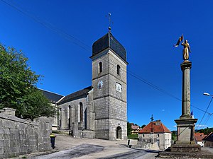
 Church of the Assumption |
||
Guyans-Vennes is a French municipality with 829 inhabitants (as of January 1 2017) in Doubs in the region Bourgogne Franche-Comté .
geography
Guyans-Vennes lies at 727 m above sea level, twelve kilometers north of Morteau and about 42 kilometers east of the city of Besançon (as the crow flies). The village extends in the Jura , in a valley that is slightly sunk into the Vennes basin, at the southern foot of the Bois de Gassard forest and west of the Dessoubre valley.
The area of the 19.67 km² municipal area covers a section of the French Jura. The main part of the area is occupied by the Vennes Basin, which is approximately four kilometers wide and almost ten kilometers long and averages 770 m. It is mostly made up of arable and meadow land. The plateau has no above-ground watercourses because the rainwater seeps into the karstified subsoil. The dry valley of Guyans-Vennes, which topographically belongs to the catchment area of the Dessoubre, is sunk into the basin .
To the north and northwest, the basin is flanked by a wooded ridge, which includes the Bois de Gassard (970 m), the Frémont (at 984 m the highest elevation in Guyans-Vennes) and the Bois du Roi (859 m). This ridge forms an anticline of the Jura folds and is oriented in the south-west-north-east direction according to the direction of the mountain range. The communal soil is delimited in the north by the erosion valley of the Reverotte , in the east by the Dessoubre valley incision, whereby the border does not run along the rivers, but on the steep valley slopes, partly criss-crossed by rock bands. The community area extends with a narrow tip to the east to the plateau of Le Russey south of the Cirque de Consolation rock circus .
In addition to the actual town center, Guyans-Vennes also includes various hamlets and numerous individual farms, including:
- Village-Haut (735 m) in the valley basin of Guyans-Vennes at the foot of the Bois de Gassard
- Les Plains de Guyans (781 m) on a plateau in the Vennes basin
- Grand-Chaux (793 m) on a plateau in the Vennes basin, west of the Dessoubre valley
- Sous le Bois (805 m) in the Vennes basin at the eastern foot of the Bois de Gassard
Neighboring municipalities of Guyans-Vennes are Plaimbois-Vennes in the north, Plaimbois-du-Miroir , Laval-le-Prieuré , Consolation-Maisonnettes , Mont-de-Laval and Le Bélieu in the east, Fuans and Fournets-Luisans in the south and Vennes in the west .
history
The municipality of Guyans-Vennes was populated very early. A tumulus is dated back to the late Bronze Age . Traces of a Roman camp have been found near the hamlet of Grand-Chaux. In the Middle Ages, Guyans-Vennes first belonged to the Montfaucon dominion , then to the Vennes dominion. Together with Franche-Comté , the village came to France with the Peace of Nijmegen in 1678. Guyans-Vennes has been a member of the Communauté de communes du Pays de Pierrefontaine-Vercel, comprising 44 localities, since 1998 .
On January 1, 2009, the arrondissement membership of the municipality was changed. Previously belonging to the Arrondissement Besançon , all municipalities of the canton came to the Arrondissement Pontarlier.
Attractions
The Church of the Assumption in Guyans-Vennes was built in the classicism style and has a painting by Notre-Dame de Consolation from around 1500. The Hôtel Normand dates from the 17th century. Ruins of the medieval castle Châtel-Neuf have been preserved.
population
| Population development | |
|---|---|
| year | Residents |
| 1962 | 481 |
| 1968 | 499 |
| 1975 | 532 |
| 1982 | 530 |
| 1990 | 536 |
| 1999 | 575 |
| 2006 | 667 |
| 2016 | 822 |
With 829 inhabitants (January 1, 2017), Guyans-Vennes is one of the small communities in the Doubs department. After the population had decreased markedly in the first half of the 20th century (in 1906 there were still 700 people), there has been a slight population growth again since the beginning of the 1960s.
Economy and Infrastructure
Guyans-Vennes was a village dominated by agriculture (livestock and dairy farming, arable farming) and forestry until the 20th century. In addition, there are now various small businesses, including in the cheese-making, wood processing and watchmaking industries. Many workers are also commuters who work in the surrounding larger towns.
The village is off the main thoroughfares, but is easily accessible from Orchamps-Vennes on the main D461 road from Besançon to Morteau. Further road connections exist with Fuans and Consolation-Maisonnettes.
literature
- Le Patrimoine des Communes du Doubs. Volume 2, Flohic Editions, Paris 2001, ISBN 2-84234-087-6 , pp. 883-885.
