Bremondans
| Bremondans | ||
|---|---|---|
|
|
||
| region | Bourgogne-Franche-Comté | |
| Department | Doubs | |
| Arrondissement | Pontarlier | |
| Canton | Valdahon | |
| Community association | Portes du Haut-Doubs | |
| Coordinates | 47 ° 14 ' N , 6 ° 24' E | |
| height | 522-664 m | |
| surface | 7.22 km 2 | |
| Residents | 86 (January 1, 2017) | |
| Population density | 12 inhabitants / km 2 | |
| Post Code | 25530 | |
| INSEE code | 25089 | |
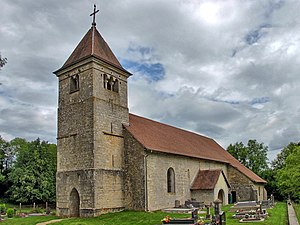
 Church of the Birth of Mary in the Leugney district |
||
Bremondans is a French commune with a population of 86 (as at 1st January 2017) in the Doubs department in the region of Bourgogne Franche-Comté .
geography
Bremondans is 540 m above sea level, 14 km south of Baume-les-Dames and about 28 km east of the city of Besançon (as the crow flies). The village extends in the Jura , in a wide hollow on both sides of the Audeux brook , north of the Vercel plateau.
The area of the 7.22 km² large municipality covers a section of the French Jura. The northern and western parts of the area are occupied by the Orsans basin, which is partly covered by arable land and meadow, partly by forest. It is drained from the Audeux to the northwest to the Sesserant and Cusancin . In the east and south, an 80 to 100 m high step leads over to the Vercel plateau. At 664 m, the highest point of Bremondans is reached at the height east of the village. The municipal area also extends into the valley of the Creuse (upper reaches of the Audeux).
In addition to the actual village, Bremondans also includes several hamlets and individual farms, including:
- Amans (535 m) at Audeux in the Orsans basin
- Leugney (530 m) at Audeux in the Orsans basin
Neighboring municipalities to Bremondans are Orsans in the north, Vellerot-lès-Vercel and Villers-Chief in the east, Épenouse in the south and Belmont in the west.
history
In the Middle Ages Bremondans was the seat of its own rule. Leugney was the center of a large parish. Together with Franche-Comté , Bremondans came to France with the Peace of Nijmegen in 1678. Since 1998, Bremondans has been a member of the Communauté de communes du Pays de Pierrefontaine-Vercel, which comprises 44 localities .
On January 1, 2009 there was a change in the arrondissement membership of the municipality. Previously belonging to the Arrondissement Besançon , all municipalities of the canton came to the Arrondissement Pontarlier.
Attractions
The single-nave Romanesque listed church of the Birth of Mary in the Leugney district was built in the 12th century. The choir dates from the 16th century. The church is richly decorated , including Gothic sculptures, a wooden statue of the Blessed Virgin from the 15th century and a bronze baptismal font from the 15th century.
Remnants of the Leugney manor and castle of the Bremondans family remain.
In the center there are several old farmhouses from the 16th to 18th centuries in the characteristic style of Franche-Comté.
population
| Population development | |
|---|---|
| year | Residents |
| 1962 | 94 |
| 1968 | 99 |
| 1975 | 84 |
| 1982 | 75 |
| 1990 | 72 |
| 1999 | 79 |
| 2006 | 80 |
| 2016 | 85 |
With 86 inhabitants (January 1, 2017) Bremondans is one of the smallest municipalities in the Doubs department. After the population had decreased significantly in the first half of the 20th century (175 people were still counted in 1896), only slight fluctuations have been recorded since the mid-1970s.
Economy and Infrastructure
Until well into the 20th century, Bremondans was mainly a village characterized by agriculture (arable farming, fruit growing and cattle breeding). In addition, there are now some local small businesses. Many workers are also commuters who work in the surrounding larger towns.
The village is located off the major thoroughfares on a departmental road that leads from Baume-les-Dames to Vercel-Villedieu-le-Camp . There are other road links with Pierrefontaine-les-Varans and Courtetain-et-Salans.
literature
- Le Patrimoine des Communes du Doubs. Volume 2, Flohic Editions, Paris 2001, ISBN 2-84234-087-6 , pp. 1323-1324.
