Pierrefontaine-les-Varans
| Pierrefontaine-les-Varans | ||
|---|---|---|

|
|
|
| region | Bourgogne-Franche-Comté | |
| Department | Doubs | |
| Arrondissement | Pontarlier | |
| Canton | Valdahon | |
| Community association | Portes du Haut-Doubs | |
| Coordinates | 47 ° 13 ' N , 6 ° 32' E | |
| height | 464-943 m | |
| surface | 28.90 km 2 | |
| Residents | 1,421 (January 1, 2017) | |
| Population density | 49 inhabitants / km 2 | |
| Post Code | 25510 | |
| INSEE code | 25453 | |
| Website | www.pierrefontaine-les-varans.com | |
Pierrefontaine-les-Varans is a French commune with 1,421 inhabitants (as of January 1 2017) in Doubs in the region Bourgogne Franche-Comté and the capital of the canton of Valdahon in Arrondissement Pontarlier .
geography
Pierrefontaine-les-Varans is located at 690 m above sea level, 38 kilometers southwest of Montbéliard and about 40 kilometers east of the city of Besançon (as the crow flies). The village extends in the Jura , in the middle of the wide plateau of Pierrefontaine, north of the deeply cut valley of the Reverotte .
The area of the 28.90 km² municipality covers a section of the French Jura. The main part of the area is taken up by the low relief plateau of Pierrefontaine, which averages 700 m. It has a width of about 4 km and a length of more than 10 km and consists mainly of arable and meadow land, but also shows smaller forest areas and - especially in the northern part - boggy areas. The high plateau has no above-ground watercourses because the rainwater seeps into the karstified subsoil.
The valley of the Ruisseau du Val begins south of the village in a striking rock basin. The stream rises from a karst spring and flows into the Reverotte a short time later . This forms the southern municipal boundary. It runs in a deeply cut and partly gorge-like narrowed erosion valley ( Défilé des Epais Rochers ) to the east to Dessoubre . The eastern boundary of the high plateau is marked by the ridge of the Belmont . Here, at 946 m, the highest point of Pierrefontaine-les-Varans is reached.
In addition to the actual village, Pierrefontaine-les-Varans also includes various hamlets and numerous individual farms, including:
- La Faye (700 m) on the Pierrefontaine plateau
- Granges au Roi (725 m) on the eastern edge of the Pierrefontaine plateau
Neighboring municipalities of Pierrefontaine-les-Varans are Laviron in the north, Belleherbe , Chamesey and Bretonvillers in the east, Plaimbois-Vennes in the south and La Sommette and Germéfontaine in the west.
history
Pierrefontaine was probably founded in the late 11th or early 12th century by monks from the Vaucluse monastery. The place is mentioned in a document in 1339. Over time, the spelling changed to Pierrefotenne (1390), Pierrefontaine-en-Varest (1424), Pierrefontaine-en-Varais (1626) and Pierrefontaine-lez-Vautrans (1754) Pierrefontaine. In the Middle Ages, the village first belonged to the lordship of Montfaucon and from the early 15th century to the lordship of Montbéliard, but other lords also owned property on the territory.
During the Thirty Years War , Pierrefontaine was ravaged and burned by Swedish troops in 1639. Only in the course of the century was the high plateau repopulated by immigrants from Savoy, the Swiss cantons of Friborg and Neuchâtel and from the Val du Saugeais . Together with Franche-Comté , Pierrefontaine finally came to France in 1678 with the Peace of Nijmegen . To avoid confusion with other localities of the same name, Pierrefontaine was officially renamed Pierrefontaine-les-Varans in 1962. Today Pierrefontaine-les-Varans is a member of the Portes du Haut-Doubs municipal association .
On January 1, 2009, the arrondissement membership of the municipality was changed. Previously belonging to the Arrondissement Besançon , all municipalities of the canton came to the Arrondissement Pontarlier.
population
| Population development | |
|---|---|
| year | Residents |
| 1962 | 1289 |
| 1968 | 1412 |
| 1975 | 1501 |
| 1982 | 1538 |
| 1990 | 1505 |
| 1999 | 1351 |
| 2006 | 1280 |
| 2016 | 1414 |
With 1,421 inhabitants (January 1, 2017), Pierrefontaine-les-Varans is one of the smaller municipalities in the Doubs department. After the population in the first half of the 20th century was always in the range of 950 to 1050 people, a significant increase in population has been recorded to this day.
Economy and Infrastructure
Pierrefontaine-les-Varans was a village dominated by agriculture (cattle breeding, dairy farming and arable farming) until the 20th century. In the second half of the 20th century, various companies set up in Pierrefontaine and the village developed into a regional center. Today, Pierrefontaine-les-Varans is home to various wood processing, mechanical, electronic and electromechanical industries, mechanical engineering, the watch accessories industry (décolletage) and cheese factories.
The village is a regional road junction. There are connections with Baume-les-Dames , Sancey-le-Grand , Belleherbe, Morteau , Avoudrey and Domprel .
Attractions
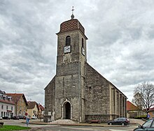
- The three-aisled church Notre-Dame de l'Assomption de la Vierge was rebuilt from 1755 to 1787 on the site of a medieval church.
- The 16th century Château de Sagey was later converted into a manor house and now houses the community library.
- Various farmhouses from the 18th and 19th centuries in the characteristic Franche-Comté style have been preserved in the village.
- Natural attractions include the valley basin of the Ruisseau du Val with its waterfall and the narrow valley of the Reverotte.
Personalities
- Jules Vuillemin (1920–2001), French philosopher and logician
literature
- Le Patrimoine des Communes du Doubs. Volume 2, Flohic Editions, Paris 2001, ISBN 2-84234-087-6 , pp. 899-903.

