
Étray
| Étray | ||
|---|---|---|
|
||
| region | Bourgogne-Franche-Comté | |
| Department | Doubs | |
| Arrondissement | Pontarlier | |
| Canton | Valdahon | |
| Community association | Portes du Haut-Doubs | |
| Coordinates | 47 ° 7 ' N , 6 ° 21' E | |
| height | 623-759 m | |
| surface | 6.00 km 2 | |
| Residents | 261 (January 1, 2017) | |
| Population density | 44 inhabitants / km 2 | |
| Post Code | 25800 | |
| INSEE code | 25227 | |
 Mairie Étray |
||

Étray is a French municipality with 261 inhabitants (as of January 1 2017) in Doubs in the region Bourgogne Franche-Comté .
geography
Étray is located at 722 m above sea level, three kilometers south of Valdahon and about 27 kilometers southeast of the city of Besançon (as the crow flies). The village extends in the Jura , on a slope slightly to the west on the plateau of Valdahon, the so-called first plateau of the Jura, north of the first higher Jura ranges.
The area of the 6 km² municipality covers a section of the French Jura. The entire area is occupied by the low relief high plateau of Valdahon, which is an average of 700 m. It is predominantly made up of arable and meadow land, partly also of forest, and rises slightly towards the southeast. At the height east of the village, the highest point of Étray is reached at 759 m. The plateau has no above-ground watercourses because the rainwater seeps into the karstified subsoil. In the west, the border mostly runs in a dry valley that stretches from Nods to Étalans.
Neighboring municipalities of Étray are
- Valdahon in the north,
- Épenoy in the northeast,
- Les Premiers Sapins with Rantechaux in the east and Vanclans and Nods in the south,
- Vernierfontaine and Fallerans to the west.
history
Étray is mentioned for the first time in 937. In the Middle Ages the village belonged to the Cicon dominion. Together with Franche-Comté , it came to France with the Peace of Nijmegen in 1678. Today Étray is a member of the Portes du Haut-Doubs municipal association .
On January 1, 2009 there was a change in the arrondissement membership of the municipality. Previously belonging to the Arrondissement Besançon , all municipalities of the canton came to the Arrondissement Pontarlier.
Attractions
The Saint-Ferréol-et-Ferjeux church was built in 1736 in the classicism style. Various farmhouses in the characteristic style of Franche-Comté from the 18th and 19th centuries have been preserved in the town center. There is a small country chapel in a grove to the east of the village.

Saint-Ferréol-et-Ferjeux church
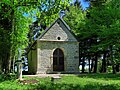
chapel


population
| Population development | |
|---|---|
| year | Residents |
| 1962 | 99 |
| 1968 | 109 |
| 1975 | 88 |
| 1982 | 104 |
| 1990 | 115 |
| 1999 | 132 |
| 2006 | 172 |
| 2016 | 262 |
With 261 inhabitants (January 1, 2017), Étray is one of the small communities in the Doubs department. After the population had decreased significantly in the first half of the 20th century (182 people were still counted in 1881), the population has continued to grow steadily since the mid-1970s.
Economy and Infrastructure
Until well into the 20th century, Étray was primarily a village characterized by agriculture (arable farming, fruit growing and cattle breeding). In addition, there are now some local small businesses. In the meantime, the village has also turned into a residential community. Many workers are commuters who work in the larger towns in the area.
The village is off the major thoroughfares on a departmental road that leads from Valdahon to Nods. Road connections exist with Épenoy and Vernierfontaine.
literature
- Le Patrimoine des Communes du Doubs. Volume 2, Flohic Editions, Paris 2001, ISBN 2-84234-087-6 , p. 1334.