Granges-Narboz
| Granges-Narboz | ||
|---|---|---|
|
|
||
| region | Bourgogne-Franche-Comté | |
| Department | Doubs | |
| Arrondissement | Pontarlier | |
| Canton | Pontarlier | |
| Community association | Grand Pontarlier | |
| Coordinates | 46 ° 53 ′ N , 6 ° 19 ′ E | |
| height | 808–1,025 m | |
| surface | 16.22 km 2 | |
| Residents | 1,226 (January 1, 2017) | |
| Population density | 76 inhabitants / km 2 | |
| Post Code | 25300 | |
| INSEE code | 25293 | |
| Website | www.grangesnarboz.com | |
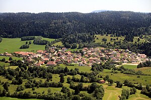
 Aerial view |
||
Granges-Narboz is a French commune with 1,226 inhabitants (as of January 1 2017) in Doubs in the region Bourgogne Franche-Comté .
geography
Granges-Narboz is 842 m above sea level, about four kilometers southwest of the city of Pontarlier (as the crow flies). The village extends in the Jura , on the southern edge of the wide high plateau of Arlier (Pontarlier-Frasne), at the northern foot of the Montagne du Laveron .
The area of the 16.22 km² large municipality covers a section of the French Jura. The northern part of the area is occupied by the high plateau of Arlier, which is on average at 820 m. It is partly covered by meadows and partly by moorland and is drained by two short streams northwards to the canalised Drugeon . To the south, the community area extends over a wooded slope on the wide ridge of the Montagne du Laveron, which forms an anticline of the Jura in geological and tectonic terms . The highest point of Granges-Narboz is reached here at 1025 m. These plateaus show a loose structure of pastureland and forest. There are no surface rivers here because the rainwater seeps into the karstified subsoil.
The municipality of Granges-Narboz consists of various districts, hamlets and individual farms, including:
- Granges-l'Église ( 839 m ) at the north foot of the Montagne du Laveron
- Granges lingerie ( 831 m ) at the northern foot of the Montagne du Laveron
- Granges-Dessus ( 999 m ) on the plateau of the Montagne du Laveron
Neighboring communities of Granges-Narboz are Chaffois , Houtaud and Pontarlier in the north, La Cluse-et-Mijoux in the east, Oye-et-Pallet and La Planée in the south and Sainte-Colombe in the west.
history
In the Middle Ages, Granges-Narboz was part of the Pontarlier rule. Together with Franche-Comté , the village came to France with the Peace of Nijmegen in 1678.
Attractions
The village church of Sainte-Brigide in Granges-l'Église was built from 1632 and shows forms of the late Gothic flamboyant style.
population
| Population development | |
|---|---|
| year | Residents |
| 1962 | 217 |
| 1968 | 249 |
| 1975 | 401 |
| 1982 | 434 |
| 1990 | 519 |
| 1999 | 627 |
| 2006 | 669 |
| 2016 | 1194 |
With 1,226 inhabitants (January 1, 2017) Granges-Narboz is one of the small communities in the Doubs department. After the population had decreased in the first half of the 20th century (309 people were still counted in 1896), a significant increase in population has been recorded again since the beginning of the 1970s. Since then, the number of inhabitants has tripled.
Economy and Infrastructure
Until well into the 20th century, Granges-Narboz was primarily a village characterized by agriculture, in particular dairy and cattle breeding, as well as forestry. In addition, there are now some small and medium-sized businesses, including a modern cheese dairy and companies in the wood processing and advertising sectors. In the meantime, the village has also turned into a residential community. Many workers are commuters who work in the larger towns in the area.
The village is off the main thoroughfares on a departmental road that leads from Pontarlier to La Rivière-Drugeon . The area is crossed by the railway line that connects Frasne with Pontarlier and Neuchâtel .
literature
- Le Patrimoine des Communes du Doubs. Volume 2, Flohic Editions, Paris 2001, ISBN 2-84234-087-6 , p. 968.

