
Montbenoît
| Montbenoît | ||
|---|---|---|

|
|
|
| region | Bourgogne-Franche-Comté | |
| Department | Doubs | |
| Arrondissement | Pontarlier | |
| Canton | Ornans | |
| Community association | Montbenoît | |
| Coordinates | 47 ° 0 ′ N , 6 ° 28 ′ E | |
| height | 762-1,125 m | |
| surface | 5.03 km 2 | |
| Residents | 396 (January 1, 2017) | |
| Population density | 79 inhabitants / km 2 | |
| Post Code | 25650 | |
| INSEE code | 25390 | |
| Website | www.montbenoit.fr | |
.JPG) Montbenoît on the Doubs |
||

Montbenoît is a French municipality with 396 inhabitants (as of January 1 2017) in Doubs in the region Bourgogne Franche-Comté . Montbenoît belongs to the canton of Ornans in the arrondissement of Pontarlier .
geography
Montbenoît is located at 780 m, about 13 kilometers northeast of the city of Pontarlier (as the crow flies). The street village extends in the Jura , in the Val du Saugeais on the northern bank of the Doubs , north of the Jura heights of the Montagne du Larmont , near the border with Switzerland .
The area of the municipality of 5.03 km² covers a section of the French Jura. The northern part of the area is taken up by the open valley low of the Doubs, which flows here to the northeast through the Val du Saugeais. The slopes adjacent to the north also belong to Montbenoît. To the south, the community area extends over a relatively steep, wooded slope up to the height of the Forêt Domaniale de Ban (1085 m). At 1125 m, the highest point in Montbenoît is reached on a ridge belonging to the Montagne du Larmont system.
Neighboring municipalities of Montbenoît are La Longeville in the north, Ville-du-Pont in the east, Hauterive-la-Fresse in the south and Montflovin in the west.
history
The local history of Montbenoît probably goes back to the 11th century when a hermit named Benoît settled here. With a donation from the Lords of Joux in the first half of the 12th century, a clergyman from Besançon was commissioned to found a monastery. This Augustinian canon monastery has been documented since 1141. The monks, some of whom had come here from Switzerland, took care of clearing and reclaiming the near and far area. In the following centuries, Montbenoît held the monastic rule of the Val du Saugeais, under the suzerainty of the Free County of Burgundy and the Lords of Joux. The monastery quickly developed into the spiritual center of the Haut-Doubs. The monastery church became the burial place of the Lords of Joux.
During the Thirty Years War , the monastery was devastated by troops from Duke Bernhard von Sachsen-Weimar . Together with the Franche-Comté , Montbenoît came to France with the Peace of Nijmegen in 1678. Thereafter the rule was administered by the monks until 1773. Since the French Revolution , Montbenoît was the capital of the canton of the same name. In 1947 it was also declared the capital of the micronation Free Republic of Saugeais (République du Saugeais).
Attractions

Montbenoît monastery and church together form the most important medieval religious complex in the Doubs department, which is very well preserved. The construction of the Romanesque monastery church began in the 12th century. Various changes were undertaken in the later centuries; The choir room, for example, dates from the 16th century and is in the late Gothic flamboyant style. The church has a rich interior , including the carved choir stalls (16th century), various important statues from the 15th and 16th centuries and a pulpit from the 17th century.
The structure of the monastery buildings mainly dates from the 15th and 16th centuries. The cloister, which is in Romanesque-Gothic style, also dates from this period. At the western entrance to the village is the Morand-Val manor.

Choir stalls

Choir stalls:
Samson and Dalila
church
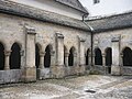
Cloister

Vaulted ceiling


population
With 396 inhabitants (as of January 1, 2017), Montbenoît is one of the small communities in the Doubs department. After the population had decreased markedly in the first half of the 20th century (283 people were still counted in 1886), there has been significant population growth again since the beginning of the 1980s.
| Population development | ||||||||
|---|---|---|---|---|---|---|---|---|
| year | 1962 | 1968 | 1975 | 1982 | 1990 | 1999 | 2009 | 2016 |
| Residents | 180 | 205 | 182 | 163 | 238 | 219 | 383 | 395 |
Economy and Infrastructure
Until the 20th century, Montbenoît was predominantly a village characterized by agriculture (cattle breeding and dairy farming) and forestry. In addition, there are now various local small businesses, mainly in the field of handicrafts and handicrafts. Many workers are also commuters who work in the surrounding larger towns.
The village is well developed in terms of traffic. It is on the D437 departmental road from Pontarlier to Morteau . Other road connections exist with La Longeville, La Chaux and Montflovin. The operation of the former railway line from Pontarlier to Gilley was discontinued.
literature
- Le Patrimoine des Communes du Doubs. Volume 2, Flohic Editions, Paris 2001, ISBN 2-84234-087-6 , pp. 752-755.