La Chaux (Doubs)
| La Chaux | ||
|---|---|---|
|
|
||
| region | Bourgogne-Franche-Comté | |
| Department | Doubs | |
| Arrondissement | Pontarlier | |
| Canton | Ornans | |
| Community association | Montbenoît | |
| Coordinates | 47 ° 1 ′ N , 6 ° 26 ′ E | |
| height | 864-1,113 m | |
| surface | 16.94 km 2 | |
| Residents | 558 (January 1, 2017) | |
| Population density | 33 inhabitants / km 2 | |
| Post Code | 25650 | |
| INSEE code | 25139 | |
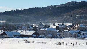
 La Chaux in winter |
||
La Chaux is a French municipality with 558 inhabitants (as of January 1 2017) in Doubs in the region Bourgogne Franche-Comté . Unofficially, La Chaux is also called La Chaux-de-Gilley to distinguish it from other municipalities of the same name .
geography
La Chaux is located at 884 m , about 15 km north-northeast of the city of Pontarlier (as the crow flies). The street village extends in the Jura , in a wide hollow between the heights of Crêt Monniot in the north and the Bois des Courtots forest in the south, in the Val du Saugeais region .
The area of the 16.94 km² large municipality covers a section of the French Jura. The central part of the area is occupied by a longitudinal trough which, from a geological and tectonic point of view, forms a syncline in the Jura folds . This depression is just over 1 km wide, 6 km long and averages 880 m. It is mainly covered by meadow and pasture land. The plateau has no above-ground watercourses because the rainwater seeps into the karstified subsoil. To the north, the municipality extends to the wide ridge of the Crêt Monniot , on which the highest point of La Chaux is reached at 1113 m. This ridge forms an anticline and is oriented in the south-west-north-east direction according to the strike direction of the Jura in this region. To the south, the community area extends to the adjacent forest heights with the Bois des Courtots and the Bois de Montflovin (up to 1030 m).
In addition to the actual village, La Chaux also includes various hamlets and numerous individual farms, including:
- Les Plans ( 877 m ) in the western part of the La Chaux valley
- Les Champs Guyons ( 885 m ) in the La Chaux valley
- Le Crêt ( 905 m ) in the La Chaux valley at the southern foot of the Crêt Monniot
Neighboring municipalities of La Chaux are Aubonne and Arc-sous-Cicon in the north, Gilley and La Longeville in the east, Montflovin , Maisons-du-Bois-Lièvremont and Arçon in the south and Bugny and Ouhans in the west.
history
In the Middle Ages, La Chaux belonged to the monastic rule of Montbenoît . Together with Franche-Comté , the village came to France with the Peace of Nijmegen in 1678.
Attractions
The village church of Saint-Antide was built in the second half of the 19th century. Various farmhouses from the 18th and 19th centuries in the traditional Haut-Doubs style have been preserved in the town center.
population
| Population development | |
|---|---|
| year | Residents |
| 1962 | 381 |
| 1968 | 380 |
| 1975 | 339 |
| 1982 | 348 |
| 1990 | 351 |
| 1999 | 376 |
| 2010 | 424 |
With 558 inhabitants (as of January 1, 2017), La Chaux is one of the small communities in the Doubs department. After the population had decreased significantly in the first half of the 20th century (569 people were counted in 1896), population growth has been recorded again since the beginning of the 1980s.
Economy and Infrastructure
Until well into the 20th century, La Chaux was predominantly a village characterized by agriculture (cattle breeding and dairy farming). In addition, there are now various local small businesses. Many workers are also commuters who work in the surrounding larger towns.
The village is located off the major thoroughfares on a department road that leads from Gilley to Bugny. Other road links exist with La Longeville and Arc-sous-Cicon.
literature
- Le Patrimoine des Communes du Doubs. Volume 2, Flohic Editions, Paris 2001, ISBN 2-84234-087-6 , pp. 743-744.
