Bugny
| Bugny | ||
|---|---|---|
|
|
||
| region | Bourgogne-Franche-Comté | |
| Department | Doubs | |
| Arrondissement | Pontarlier | |
| Canton | Ornans | |
| Community association | Montbenoît | |
| Coordinates | 47 ° 0 ′ N , 6 ° 21 ′ E | |
| height | 845-970 m | |
| surface | 4.77 km 2 | |
| Residents | 217 (January 1, 2017) | |
| Population density | 45 inhabitants / km 2 | |
| Post Code | 25520 | |
| INSEE code | 25099 | |
Bugny is a commune with 217 inhabitants (as of January 1 2017) Doubs in the region Bourgogne Franche-Comté .
geography
Bugny is located at 855 m , about ten kilometers north of the city of Pontarlier (as the crow flies). The village extends in the Jura , on a high plateau at the southern foot of Mont Pelé, between the erosion valley of the Loue in the north-west and the Arlier plateau (Pontarlier-Frasne) in the south.
The area of the 4.77 km² municipal area covers a section of the French Jura. The main part of the area is taken up by the Bugny plateau, which is an average of 860 m. It is mainly made up of meadow and pasture land. The plateau has no above-ground watercourses because the rainwater seeps into the karstified subsoil. To the north, the municipality extends to the wooded southern slope of Mont Pelé, where Bugny’s highest elevation is reached at 970 m. This ridge forms an anticline of the Jura folds and is oriented in the south-west-north-east direction according to the direction of the mountain range in this region.
Neighboring communities of Bugny are Ouhans in the north, La Chaux in the east, Arçon and Vuillecin in the south and Goux-les-Usiers in the west.
Attractions
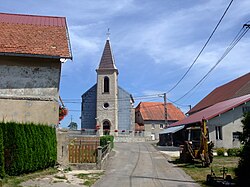
The village church of l'Immaculée-Conception (Immaculate Conception) in Bugny was built in 1673. Since 1947 Bugny has also belonged to the micronation Free Republic of Saugeais ( République du Saugeais ).
population
| Population development | |
|---|---|
| year | Residents |
| 1962 | 81 |
| 1968 | 88 |
| 1975 | 79 |
| 1982 | 94 |
| 1990 | 108 |
| 1999 | 115 |
| 2006 | 147 |
| 2016 | 217 |
With 217 inhabitants (January 1, 2017) Bugny is one of the smallest communities in the Doubs department. After the population had decreased significantly in the first half of the 20th century (150 people were still counted in 1896), slight population growth has been recorded again since the mid-1970s.
Economy and Infrastructure
Until well into the 20th century, Bugny was a village dominated by agriculture (dairy farming and cattle breeding, arable farming). Even today, the residents live mainly from their work in the first sector. Outside of the primary sector there are almost no jobs in the village. Some workers are also commuters who work in the surrounding larger towns.
The village is located away from the major thoroughfares but is easily accessible from the main road N57, which leads from Besançon to Pontarlier. Other road connections exist with Gilley , Arçon and Goux-les-Usiers.
literature
- Le Patrimoine des Communes du Doubs. Volume 2, Flohic Editions, Paris 2001, ISBN 2-84234-087-6 , pp. 742-743.

