Les Allies
| Les Allies | ||
|---|---|---|
|
|
||
| region | Bourgogne-Franche-Comté | |
| Department | Doubs | |
| Arrondissement | Pontarlier | |
| Canton | Ornans | |
| Community association | Montbenoît | |
| Coordinates | 46 ° 57 ′ N , 6 ° 27 ′ E | |
| height | 943-1,171 m | |
| surface | 5.28 km 2 | |
| Residents | 158 (January 1, 2017) | |
| Population density | 30 inhabitants / km 2 | |
| Post Code | 25300 | |
| INSEE code | 25012 | |
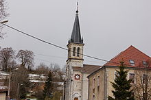
 View of Les Alliès |
||
Les Alliés is a French municipality with 158 inhabitants (as of January 1 2017) in Doubs in the region Bourgogne Franche-Comté .
geography
Les Alliés is located at 975 m, about nine kilometers northeast of the city of Pontarlier (as the crow flies). The village extends in the Jura , in the longitudinal basin of the Ruisseau des Etraches south of the Doube valley , at the northern foot of the Montagne du Larmont , in the immediate vicinity of the border with Switzerland .
The area of the 5.28 km² large municipality covers a section of the French Jura. The central part of the area is occupied by the valley of the Ruisseau des Etraches , which drains a longitudinal trough in the system of the Jura chains to the southwest to the Doubs. The municipal area extends to the surrounding heights, which are oriented towards the southwest-northeast according to the strike direction of the Folded Jura in this region. To the north of the valley are the heights of Les Champs (up to 1090 m), partly with pastureland and partly with forest , in the south the wooded ridge of the Cernet , on which the highest elevation of Les Alliés is reached at 1171 m.
Neighboring municipalities to Les Alliés are Pontarlier in the west, Hauterive-la-Fresse in the north and the Swiss municipalities of Val-de-Travers and Les Verrières in the southeast.
history
In the Middle Ages, the small village called Les Arcenets at that time belonged to the monastic rule of Montbenoît. After another clearing and redesign, the village was given the name Les Allemands (translated the German ). Shortly after the start of the First World War , the village was renamed Les Alliés (translated the Allies ) in 1915 after a referendum .
Attractions
The village church of Sainte-Foy in Les Alliés was rebuilt in the 19th century and has rich furnishings , including a carved wooden altar from the 18th century and an altar of the Blessed Virgin from the 17th century.
population
| Population development | |
|---|---|
| year | Residents |
| 1962 | 83 |
| 1968 | 61 |
| 1975 | 67 |
| 1982 | 63 |
| 1990 | 56 |
| 1999 | 103 |
| 2016 | 150 |
With 158 inhabitants (as of January 1, 2017) Les Alliés is one of the smallest communities in the Doubs department. After the population had decreased markedly in the first half of the 20th century (230 people were counted in 1886), there has been significant population growth again since the beginning of the 1990s.
Economy and Infrastructure
Until well into the 20th century, Les Alliés was predominantly a village characterized by agriculture (dairy farming and cattle breeding) and forestry. Even today, the residents live mainly from their work in the first sector. Outside the primary sector there are few jobs in the village. Some workers are also commuters who work in the surrounding larger towns.
The village is located off the main thoroughfares on a departmental road that leads from Pontarlier to Les Gras . Another road connection is with Montbenoît .
literature
- Le Patrimoine des Communes du Doubs. Volume 2, Flohic Editions, Paris 2001, ISBN 2-84234-087-6 , pp. 733-734.

