Montagne du Larmont
| Montagne du Larmont | ||
|---|---|---|
|
Fort Mahler |
||
| height | 1323 m | |
| location | Canton of Neuchâtel , Switzerland and Doubs , France | |
| Mountains | law | |
| Dominance | 9.5 km → Roches Blanches | |
| Notch height | 204 m ↓ west of Mont Brenin | |
| Coordinates , ( CH ) | 46 ° 54 '53 " N , 6 ° 25' 48" O ( 523162 / 196.46 thousand ) | |
|
|
||
| Type | Folded Jurassic | |
| rock | Malmkalk | |
The Montagne du Larmont is a long ridge in the Jura , in the border area between Switzerland (canton Neuchâtel ) and France ( Doubs department ). It extends over a length of about 25 km and is oriented towards the southwest-northeast according to the general fold structure of the Jura in this region. The ridge of the Montagne du Larmont reaches a height of 1150 m to 1300 m . The two highest peaks are the Grand Taureau ( 1323 m ) and the Mont Châteleu ( 1301 m ), both of which are entirely on French territory.
geology
In structural and geological terms, the Montagne du Larmont forms an anticline of the Jura folds up to 4 km wide . It is bounded in the south by the synclines of the Vallon des Verrières and the Vallée de la Brévine , in the north by a valley furrow that runs parallel to the Doubs and extends from Pontarlier via Les Alliés to Morteau . On Swiss territory, the anticline of Le Cernil, which flanks the La Brévine basin on the south side, splits off from the Larmont anticline. The south-western border of the Montagne du Larmont is formed by a fault line that can be traced from Montricher to Pontarlier. The Doubs has created its valley along the northern part of this transform fault near Pontarlier. It separates the Montagne du Larmont from the Montagne du Laveron . In the northeast, the demarcation is not precisely defined, it is in the area between La Brévine and Le Cerneux-Péquignot .
The competent rock strata of the Montagne du Larmont on the surface come mainly from limestone sediments from the Upper Jurassic ( Malm ). Over time, the vertex of the Larmont anticline was attacked and broken open at weak points by erosion processes . The Théverot and Ruisseau des Entreportes streams have created deep erosion valleys in some cases. As a result, the softer marl layers of the Argovia and partly the main roe stone from the middle Jurassic period were exposed. That is why the Montagne du Larmont today consists of a higher southern branch with the heights Grand Taureau , Grosse Prize ( 1258 m ) and Châteleu ( 1260 m ) and a lower northern branch with Bois de la Motte ( 1103 m ), Le Buclet ( 1164 m) ), La Côte du Cerf ( 1210 m ) and Rochers du Cerf ( 1195 m ). In between runs a more or less pronounced anticline valley, which is always around 1 km wide.
geography
At the height of the Montagne du Larmont there are predominantly forests, which are loosened up by characteristic Jura high pastures with mighty spruce trees , either individually or in groups. There are various mountain farms and dairy farms and the typical dry stone walls of the Upper Jura to limit the pastures.
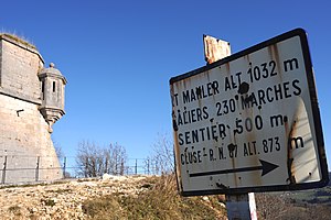
The Grand Taureau is a beautiful lookout point in the French Jura. The ridge serves as a local recreation area for Pontarlier. There are several ski lifts on its northwest slope. On a rock spur southwest of the Montagne du Larmont stands the old Château de Joux , which was expanded into an important fortification in the 19th century. In connection with this line of fortifications, the Fort du Larmont Inférieur (also called Fort Mahler , 1010 m ) and Fort du Larmont Supérieur (also called Fort Catinat , 1176 m ) were built on the Montagne du Larmont from 1844 to 1851 . Both forts are in decline and no longer accessible.
The ridge was first mentioned in documents in 1382 under the name Armont ; from 1383 the name Larmont has been handed down. The word is made up of ar (alp) and mont (mountain), whereby the article was agglutinated.


