Vennes
| Vennes | ||
|---|---|---|
|
|
||
| region | Bourgogne-Franche-Comté | |
| Department | Doubs | |
| Arrondissement | Pontarlier | |
| Canton | Valdahon | |
| Community association | Portes du Haut-Doubs | |
| Coordinates | 47 ° 9 ' N , 6 ° 33' E | |
| height | 758-1,000 m | |
| surface | 7.31 km 2 | |
| Residents | 182 (January 1, 2017) | |
| Population density | 25 inhabitants / km 2 | |
| Post Code | 25390 | |
| INSEE code | 25600 | |
Vennes is a French municipality with 182 inhabitants (as of January 1 2017) in Doubs in the region Bourgogne Franche-Comté .
geography
Vennes is located at 795 m above sea level, 12 kilometers north-northwest of Morteau and about 40 kilometers east of the city of Besançon (as the crow flies). The village extends in the Jura , on the northwestern edge of the Vennes basin, at the foot of the forest heights of Froid Mont .
The area of the 7.31 km² municipality covers a section of the French Jura. The southern part of the area is occupied by the Vennes Basin, which is about 4 km wide and almost 10 km long and averages 770 m. It is mostly made up of arable and meadow land. The plateau has no above-ground watercourses because the rainwater seeps into the karstified subsoil. Deep in the basin is a dry valley that stretches from Vennes to Guyans-Vennes and topographically belongs to the Dessoubre catchment area .
To the northwest, the community area extends to the partly wooded, partly pastureland ridge that separates the Vennes basin from the northern Reverotte valley. The ridge, subdivided by several combes, forms an anticline of the Jura folds and is oriented in the south-west-north-east direction according to the direction of the mountain range. Important points are the Roche Barchey (988 m) in the extreme west, the height of Sainte-Radegonde (965 m), of Pré Renaud (with 1007 m the highest point in the Vennes) and the Froid Mont (1006 m).
The hamlet of Les Plains (804 m) on the plateau in the Vennes basin and a few individual farms belong to Vennes. Neighboring municipalities of Vennes are Plaimbois-Vennes in the north, Guyans-Vennes in the east, Fournets-Luisans and Orchamps-Vennes in the south and Loray in the west.
history
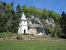
The village of Vennes developed below the medieval castle of the same name, which was the center of an important rule and encompassed the Vennes basin. It was on a rocky ledge over the narrow point of a dry valley north of the village. In 1541, the Notre-Dame de Sainte Radegonde chapel was built on the ridge north-west of Vennes, near which there was a hermitage. Today Vennes is a member of the Portes du Haut-Doubs municipal association .
On January 1, 2009, the arrondissement membership of the municipality was changed. Previously belonging to the Arrondissement Besançon , all municipalities of the canton came to the Arrondissement Pontarlier.
Attractions
The current Sainte-Radegonde chapel dates from 1854. Only a few remains of the former Vennes Castle are visible.
population
| Population development | |
|---|---|
| year | Residents |
| 1962 | 112 |
| 1968 | 107 |
| 1975 | 79 |
| 1982 | 76 |
| 1990 | 82 |
| 1999 | 108 |
| 2006 | 131 |
| 2016 | 169 |
With 182 inhabitants (January 1, 2017), Vennes is one of the smallest municipalities in the Doubs department. After the population had decreased significantly in the first half of the 20th century (178 people were still counted in 1881), population growth has been recorded again since the beginning of the 1980s.
Economy and Infrastructure
Until well into the 20th century, Vennes was a village dominated by agriculture (dairy farming, cattle breeding, arable farming). Even today, the residents live mainly from their work in the first sector. Outside of the primary sector there are almost no jobs in the village. Some workers are also commuters who work in the surrounding larger towns.
The village is well developed in terms of traffic. It is easily accessible from Orchamps-Vennes on the D461 main road from Besançon to Morteau. Another road connection is with Fuans.
literature
- Le Patrimoine des Communes du Doubs. Volume 2, Flohic Editions, Paris 2001, ISBN 2-84234-087-6 , p. 908.

