Ville-du-Pont
| Ville-du-Pont | ||
|---|---|---|
|
|
||
| region | Bourgogne-Franche-Comté | |
| Department | Doubs | |
| Arrondissement | Pontarlier | |
| Canton | Ornans | |
| Community association | Montbenoît | |
| Coordinates | 47 ° 0 ′ N , 6 ° 29 ′ E | |
| height | 758–1,199 m | |
| surface | 15.02 km 2 | |
| Residents | 315 (January 1, 2017) | |
| Population density | 21 inhabitants / km 2 | |
| Post Code | 25650 | |
| INSEE code | 25620 | |
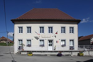
 Mairie Ville-du-Pont |
||
Ville-du-Pont is a French municipality with 315 inhabitants (as of January 1 2017) in Doubs in the region Bourgogne Franche-Comté .
geography
Ville-du-Pont is located at 782 m , about 15 kilometers northeast of the city of Pontarlier (as the crow flies). The village extends in the Jura , on the northern side of the Doubs valley , in the Val du Saugeais, at the northern foot of the Jura heights of the Montagne du Larmont , near the border with Switzerland .
The area of the municipal area of 15.02 km² covers a section of the French Jura. On the left (north) side of the Doubs, only the immediate vicinity of the village belongs to the municipality. The Doubs flows here in a relatively wide valley low to the northeast through the Val du Saugeais and enters the Défilé d'Entre-Roches below Ville-du-Pont . In this gorge-like section, which is accompanied on both sides by striking rock walls, it forms the northern border. The community area extends to the east and south-east into the valley basin of Les Jarrons and the adjacent Jura heights ( Mont de Grand'Combe , 1020 m; Le Grand Bois ). The arid Jura plateaus are partly wooded, partly made up of pastureland and have various hollows and knolls. The southern border runs on the crest of the Rochers du Cerf , on which the highest point of Ville-du-Pont is reached at 1199 m. This ridge belongs to the chain system of the Montagne du Larmont and drops to the south with a high rock face to the valley of Thévenot .
In addition to the actual village, Ville-du-Pont also includes various hamlets and numerous individual farms, including:
- Spey ( 845 m ) in an elevated position on the southern side of the Doubs valley
- Les Jarrons ( 853 m ) in a hollow south of the Doubs
- Les Ellais ( 902 m ) on the plateau west of Mont de Grand'Combe
- Mont de Spey ( 937 m ) at the height south of the Doube valley
- Les Rochettes ( 968 m ) in a hollow at the height south of the Doube valley
- Combe Benoît ( 988 m ) on the plateau north of the Rochers du Cerf
Neighboring municipalities to Ville-du-Pont are Hauterive-la-Fresse , Montbenoît and La Longeville in the west, Les Combes in the north, Grand'Combe-Châteleu and Les Gras in the east and the Swiss municipality of La Brévine in the south.
history
In the Middle Ages, Ville-du-Pont belonged to the monastic rule of Montbenoît. Together with Franche-Comté , the village came to France with the Peace of Nijmegen in 1678.
Attractions
The single-nave Saint-Joseph village chapel was built in the 17th century.
population
| Population development | |
|---|---|
| year | Residents |
| 1962 | 314 |
| 1968 | 300 |
| 1975 | 249 |
| 1982 | 239 |
| 1990 | 246 |
| 1999 | 264 |
| 2004 | 271 |
| 2016 | 304 |
With 315 inhabitants (as of January 1, 2017) Ville-du-Pont is one of the small communities in the Doubs department. After the population had decreased significantly in the first half of the 20th century (623 people were still counted in 1881), slight population growth has been recorded again since the beginning of the 1980s.
Economy and Infrastructure
Until well into the 20th century, Ville-du-Pont was predominantly a village characterized by agriculture (cattle and dairy farming, arable farming) and forestry. In addition, there are now various local small businesses. Many workers are also commuters who work in the surrounding larger towns.
The village is well developed in terms of traffic. It is on the main D437 road from Pontarlier to Morteau . There are other road links with La Longeville, Les Gras and Grand'Combe-Châteleu.
literature
- Le Patrimoine des Communes du Doubs. Volume 2, Flohic Editions, Paris 2001, ISBN 2-84234-087-6 , pp. 761-763.

