Consolation duplexes
| Consolation duplexes | ||
|---|---|---|
|
|
||
| region | Bourgogne-Franche-Comté | |
| Department | Doubs | |
| Arrondissement | Pontarlier | |
| Canton | Valdahon | |
| Community association | Portes du Haut-Doubs | |
| Coordinates | 47 ° 9 ' N , 6 ° 36' E | |
| height | 495-880 m | |
| surface | 4.31 km 2 | |
| Residents | 33 (January 1, 2017) | |
| Population density | 8 inhabitants / km 2 | |
| Post Code | 25390 | |
| INSEE code | 25161 | |
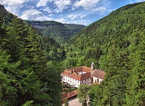
 former monastery complex |
||
Consolation-Maisonnettes is a French commune with a population of 33 (as at 1st January 2017) in the Doubs department in the region of Bourgogne Franche-Comté .
geography
Consolation-Maisonnettes is located at 515 m above sea level, eleven kilometers north of Morteau and about 43 kilometers south-southwest of the city of Montbéliard (as the crow flies). The village extends in the Jura , in the deeply cut valley of the Dessoubre below its source in the rock arena of the Cirque de Consolation.
The area of the 4.31 km² large municipality covers a section of the French Jura. The main part of the area is taken up by the Dessoubre valley, which is sunk more than 300 m deep into the Jura plateau. The Dessoubre rises above the village with a karst spring , joins other source streams (from partly intermittent sources, namely Source Noire, Source du Tabourot and Source du Langot) and then leaves the Cirque de Consolation basin, which is criss-crossed by numerous limestone bands, to the north. From the south-west a dry valley flows from the Vennes basin, the lowest part of which also belongs to the municipality, into the Dessoubre valley. The municipality extends over the wooded steep slopes down to the surrounding plateaus (800 m; on the Roche du Prêtre 870 m, a lookout point above the Cirque de Consolation). At 881 m, the highest elevation of Consolation Maisonnettes is reached on the plateau at La Picotte.
The neighboring communities of Consolation-Maisonnettes are Laval-le-Prieuré in the north, Mont-de-Laval in the east and Guyans-Vennes in the south and west.
history
The municipality of Consolation-Maisonnettes was settled very early. Numerous finds from the Bronze and Iron Ages have been made in the various caves in the area of the Cirque de Consolation.
The monastery of Consolation-Maisonnettes originally dates back to a chapel dedicated to the Blessed Virgin from the 15th century. A mini- monastery was later established here under the auspices of the Varambon. After that, the monastery served as a seminary for a long time, and since 1978 it has housed a spiritual center. The parish Maisonnettes was officially renamed Consolation-Maisonnettes in 1910. Consolation-Maisonnettes has been a member of the Portes du Haut-Doubs municipal association since 1998 .
On January 1, 2009, the arrondissement membership of the municipality was changed. Previously belonging to the Arrondissement Besançon , all municipalities of the canton came to the Arrondissement Pontarlier.
Attractions
- The single-nave former monastery church was built in 1682 and has richly carved choir stalls as well as a pulpit from the 18th century. A collection of birds and butterflies is on display in the convent buildings.
- The former monastery is surrounded by a landscaped park.
- The natural attractions of the region include the Cirque de Consolation with its various karst springs and the Belvédère de la Roche du Prêtre viewpoint.
- As part of the improvement of the tourist offer, several via ferratas were set up in 2008/2009, whereby the approx. 500 m long Tyrolienne leading across the valley is remarkable.
population
| Population development | |
|---|---|
| year | Residents |
| 1962 | 55 |
| 1968 | 63 |
| 1975 | 47 |
| 1982 | 36 |
| 1990 | 29 |
| 1999 | 46 |
| 2006 | 30th |
| 2016 | 34 |
With 33 inhabitants (January 1, 2017) Consolation-Maisonnettes is one of the smallest communes in the Doubs department. After the population had decreased markedly in the first half of the 20th century (270 people were still counted in 1896), after a long period of stagnation, a significant decline has been recorded again in recent years.
Economy and Infrastructure
Consolation-Maisonnettes was a village dominated by agriculture (cattle and dairy farming, some arable and fruit growing) well into the 20th century. In the past, the water power of the Dessoubre was used to operate a mill and sawmills. A sawmill still exists today. Today, day tourism also generates income. Some employed people are commuters who work in the larger towns in the area.
The village is located off the major thoroughfares on a departmental road that leads from Saint-Hippolyte through the Dessoubre Valley to Orchamps-Vennes .
literature
- Le Patrimoine des Communes du Doubs. Volume 2, Flohic Editions, Paris 2001, ISBN 2-84234-087-6 , pp. 867-870.
