Le Bizot
| Le Bizot | ||
|---|---|---|

|
|
|
| region | Bourgogne-Franche-Comté | |
| Department | Doubs | |
| Arrondissement | Pontarlier | |
| Canton | Morteau | |
| Community association | Plateau de Russey | |
| Coordinates | 47 ° 8 ′ N , 6 ° 40 ′ E | |
| height | 887–1,063 m | |
| surface | 7.85 km 2 | |
| Residents | 309 (January 1, 2017) | |
| Population density | 39 inhabitants / km 2 | |
| Post Code | 25210 | |
| INSEE code | 25062 | |
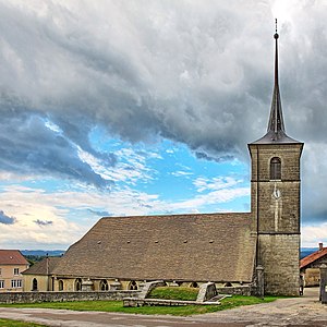
 Saint-Georges church |
||
Le Bizot is a French municipality with 309 inhabitants (as of January 1 2017) in Doubs in the region Bourgogne Franche-Comté .
geography
Le Bizot is located at 950 m , twelve kilometers northeast of Morteau and about 13 kilometers west-northwest of the city of La Chaux-de-Fonds (as the crow flies). The village extends in the Jura , in the southwest of the high plateau of Maîche, at the southern foot of the ridge of Le Mémont.
The area of the 7.85 km² municipal area covers a section of the French Jura. The southern part of the area is taken up by the high plateau of Maîche, which averages 910 m. It is mainly made up of meadow and pasture land, but also shows some forest areas. In the south, the border runs along the Ruisseau des Seignes , a stream that after a short walk through a boggy lowland seeps back into the karst subsoil. To the north, the municipal area extends over the adjacent wide ridge of Le Mémont with the Bois Banal ( 1045 m ) and the Bois de la Verdage . At 1063 m, the highest point of Le Bizot is reached at the height above the village. From a geological and tectonic point of view, this ridge forms an anticline of the Jura folds and is oriented in the south-west-north-east direction in accordance with the direction of the mountains in this region. On the ridge is the approximately 1 km² large, above-ground drainless basin of Le Mémont, which is mainly part of Le Bizot.
In addition to the actual town, Le Bizot also includes the hamlet of La Bousotte ( 920 m ) on the Maîche plateau and various individual farms. Neighboring municipalities of Le Bizot are Mont-de-Laval and Le Mémont in the north, Le Russey and Narbief in the east, La Chenalotte and Noël-Cerneux in the south and Le Bélieu and La Bosse in the west.
history
In the Middle Ages, Le Bizot belonged to the rule of Réaumont, which was under the sovereignty of the Lords of Montfaucon , and from the 15th century under that of the Counts of Montbéliard. At that time, the village was the center of an extensive parish. After the Réaumont Castle was destroyed in 1639 by the troops of Duke Bernhard von Sachsen-Weimar , Le Bizot became the seat of the rulership, which the Maison de Justice still testifies to this day. Together with Franche-Comté , the village came to France with the Peace of Nijmegen in 1678.
On January 1, 2009 there was a change in the arrondissement membership of the municipality. Previously belonging to the arrondissement of Montbéliard , all municipalities of the canton came to the arrondissement of Pontarlier.
Attractions
The village church of Saint-Georges was rebuilt in the late Gothic style at the end of the 15th and beginning of the 16th century on the site of a medieval church (first half of the 14th century) which had been destroyed in 1476 . The bell tower with forecourt dates from 1733. The three-aisled church has a rich interior , including a pulpit from the 17th century, altars from the 17th and 18th centuries, statues from the 15th to 17th centuries and remarkable wall and glass paintings . The Notre-Dame de Lourdes chapel was inaugurated in 1876.
The secular buildings include the Maison de Justice, the oldest parts of which date from the 16th century, and the Maison des Moines (early 17th century). There are also various farmhouses from the 18th century in the characteristic style of the Haut-Doubs.
population
| Population development | |
|---|---|
| year | Residents |
| 1962 | 140 |
| 1968 | 129 |
| 1975 | 94 |
| 1982 | 131 |
| 1990 | 146 |
| 1999 | 198 |
| 2005 | 243 |
| 2016 | 309 |
With 309 inhabitants (as of January 1, 2017), Le Bizot is one of the small communities in the Doubs department. After the population had decreased significantly in the first half of the 20th century (246 people were counted in 1896), the population has continued to grow again since the mid-1970s.
Economy and Infrastructure
Until well into the 20th century, Le Bizot was a village dominated by agriculture (cattle breeding and dairy farming) and forestry. In addition, there are now some local small businesses. Many workers are also commuters who work in the surrounding larger towns.
The village is located away from the main thoroughfares, but is easily accessible from the main road D437 (Montbéliard-Morteau). Further road connections exist with Le Russey, Le Mémont, La Bosse and Le Bélieu.
literature
- Le Patrimoine des Communes du Doubs. Volume 2, Flohic Editions, Paris 2001, ISBN 2-84234-087-6 , pp. 1180-1184.
