Goux-les-Usiers
| Goux-les-Usiers | ||
|---|---|---|
|
|
||
| region | Bourgogne-Franche-Comté | |
| Department | Doubs | |
| Arrondissement | Pontarlier | |
| Canton | Ornans | |
| Community association | Altitude 800 | |
| Coordinates | 46 ° 58 ′ N , 6 ° 17 ′ E | |
| height | 650-921 m | |
| surface | 17.63 km 2 | |
| Residents | 727 (January 1, 2017) | |
| Population density | 41 inhabitants / km 2 | |
| Post Code | 25520 | |
| INSEE code | 25282 | |
 Town hall and school |
||
Goux-les-Usiers is a French municipality with 727 inhabitants (as of January 1 2017) in Doubs in the region Bourgogne Franche-Comté .
geography
Goux-les-Usiers is 740 m above sea level, about ten kilometers northwest of the city of Pontarlier (as the crow flies). The clustered village extends in the Jura , on the south-eastern edge of the high plateau of Val d'Usiers, at the foot of Mont Séverin.
The area of the 17.63 km² large municipality covers a section of the French Jura. The western part of the area is taken up by the slightly undulating plateau of the Val d'Usiers, which is an average of 720 m and is mostly covered by meadows. To the northeast of the village begins a dry valley , which topographically belongs to the catchment area of the Loue . To the south-east of Goux-les-Usiers, the approximately 150 m high level of the Bois des Raffours leads to the ridge of Mont Séverin (at 919 m the highest elevation in the municipality) and Mont d'Usiers ( 880 m ) and further east to the high plateau of La Vrine (at 860 m) across. In the far east, the community area extends to the foot of Mont Pelé . The entire area has no surface watercourses because the rainwater seeps into the karstified subsoil.
Neighboring municipalities of Goux-les-Usiers are Évillers and Ouhans in the north, Bugny and Vuillecin in the east and Bians-les-Usiers in the south.
history
The parish church of Goux was first mentioned in the 12th century. Since the 13th century Goux belonged to the Usiers rule. Together with Franche-Comté , the village came to France with the Peace of Nijmegen in 1678. Goux-les-Usiers has been a member of the Altitude 800 community association since 2002 .
Attractions
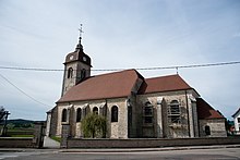
The parish church of Saint-Valère was given its current appearance when it was rebuilt in the classicist style in 1722. The Notre-Dame de Pitié chapel dates from the 17th century. Above the village there is a statue of the Holy Virgin . A manor house that was built in the 16th century was remodeled in the 18th century. In the old town center, numerous farmhouses in the traditional style of the Haut-Doubs from the 18th and 19th centuries have been preserved.
population
| Population development | |
|---|---|
| year | Residents |
| 1962 | 521 |
| 1968 | 532 |
| 1975 | 560 |
| 1982 | 574 |
| 1990 | 565 |
| 1999 | 541 |
| 2006 | 637 |
| 2016 | 728 |
With 727 inhabitants (January 1, 2017), Goux-les-Usiers is one of the small communities in the Doubs department. After the population had decreased significantly in the first half of the 20th century (726 people were still counted in 1881), the population has continued to grow continuously in recent years.
Economy and Infrastructure
Until well into the 20th century, Goux-les-Usiers was primarily a village characterized by agriculture, in particular dairy and cattle breeding, as well as forestry. In addition, there are now a few local small-scale businesses, including a modern cheese dairy. In the meantime, the village has also turned into a residential community. Many workers are commuters who work in the larger towns in the area.
The village is located off the major thoroughfares on a department road that leads from Sombacour to Ouhans. There are other road connections with Évillers, Bugny and Vuillecin.

