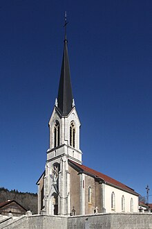
Saint-Julien-lès-Russey
| Saint-Julien-lès-Russey | ||
|---|---|---|

|
|
|
| region | Bourgogne-Franche-Comté | |
| Department | Doubs | |
| Arrondissement | Pontarlier | |
| Canton | Morteau | |
| Community association | Plateau de Russey | |
| Coordinates | 47 ° 13 ' N , 6 ° 43' E | |
| height | 590-973 m | |
| surface | 10.01 km 2 | |
| Residents | 180 (January 1, 2017) | |
| Population density | 18 inhabitants / km 2 | |
| Post Code | 25210 | |
| INSEE code | 25522 | |
 Mairie Saint-Julien-lès-Russey |
||
Saint-Julien-lès-Russey is a French municipality with 180 inhabitants (as of January 1, 2017) in the Doubs department in the region of Bourgogne Franche-Comté .
geography
Saint-Julien-lès-Russey is located at 823 m , seven kilometers southwest of Maîche and about 15 kilometers north-northwest of the Swiss city of La Chaux-de-Fonds (beeline). The village extends in the Jura , in a hollow on the northwestern edge of the Maîche plateau high above the Dessoubre valley .
The area of the 10.01 km² municipal area covers a section of the French Jura. The main part of the area is taken up by the relatively weak relief high plateau of Maîche, which averages 860 m. It is mainly made up of meadow and pasture land, but also shows some larger forest areas. The plateau has no above-ground watercourses because the rainwater seeps into the karstified subsoil. The plateau is subdivided into longitudinal hollows by several, partly rocky, ridges, including those of Saint-Julien and La Seigne. The latter is dominated in the south by the elevation of the Vieux Ban ( 962 m ), which also forms the southern boundary. Towards the Dessoubre valley, the high plateau is delimited by the heights of Le Piot (at 973 m, the highest elevation in Saint-Julien-lès-Russey) and Mont Olivot ( 886 m ). The municipality extends down to the right slope of the Dessoubre valley and also includes two short side valleys of the river.
Saint-Julien-lès-Russey consists of a lower part of the village ( 823 m ) and an upper part of the village ( 867 m ) as well as several individual farms. Neighboring municipalities of Saint-Julien-lès-Russey are Battenans-Varin and Mont-de-Vougney in the north, Maîche and Frambouhans in the east, Les Fontenelles and Bonnétage in the south and Rosureux in the west.
history
In the Middle Ages, Saint-Julien formed its own rulership, which was dependent on the barony of Belvoir . The castle was destroyed by the Confederates during the Burgundian Wars in 1474 . Together with Franche-Comté , the village came to France with the Peace of Nijmegen in 1678.
On January 1, 2009 there was a change in the arrondissement membership of the municipality. Previously belonging to the arrondissement of Montbéliard , all municipalities of the canton came to the arrondissement of Pontarlier.
Attractions
The village church of Saint-Julien originally dates from the 16th century. However, the ship was largely rebuilt in the 19th century. A chapel is located in the upper part of the village. Only a few ruins are visible of the former medieval castle. Various farmhouses from the 17th to 19th centuries in the traditional Franche-Comté style have been preserved in the town center.
population
| Population development | |
|---|---|
| year | Residents |
| 1962 | 145 |
| 1968 | 142 |
| 1975 | 151 |
| 1982 | 143 |
| 1990 | 114 |
| 1999 | 112 |
| 2016 | 171 |
With 180 inhabitants (as of January 1, 2017), Saint-Julien-lès-Russey is one of the small communities in the Doubs department. After the number of inhabitants had decreased significantly in the first half of the 20th century (in 1901 there were still 256 people counted), only slight fluctuations have been recorded since the beginning of the 1990s.
Economy and Infrastructure
Until well into the 20th century, Saint-Julien-lès-Russey was a village dominated by agriculture (cattle breeding and dairy farming) and forestry. In addition, there are now some local small businesses, including a sawmill. Many workers are also commuters who work in the surrounding larger towns.
The village is located away from the major thoroughfares on a department road that leads from Frambouhans to Bonnétage. Other road connections exist with Les Fontenelles and Mont-de-Vougney.
literature
- Le Patrimoine des Communes du Doubs. Volume 2, Flohic Editions, Paris 2001, ISBN 2-84234-087-6 , pp. 1228-1232.

