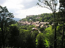
Belvoir
| Belvoir | ||
|---|---|---|

|
|
|
| region | Bourgogne-Franche-Comté | |
| Department | Doubs | |
| Arrondissement | Montbeliard | |
| Canton | Bavans | |
| Community association | Pays de Sancey-Belleherbe | |
| Coordinates | 47 ° 19 ′ N , 6 ° 36 ′ E | |
| height | 506-671 m | |
| surface | 9.31 km 2 | |
| Residents | 104 (January 1, 2017) | |
| Population density | 11 inhabitants / km 2 | |
| Post Code | 25430 | |
| INSEE code | 25053 | |
Belvoir is a French municipality with 104 inhabitants (as of January 1 2017) in Doubs in the region Bourgogne Franche-Comté .
geography
Belvoir is located at 650 m , three kilometers northeast of Sancey-le-Grand and about 26 kilometers southwest of the city of Montbéliard (as the crow flies). The village extends in the Jura , on a spur of the high plateau of Mont de Belvoir reaching south, on the eastern edge of the basin of Sancey (Vallon de Sancey), south of the ridge of the Lomont chain .
The area of the 9.31 km² large municipality covers a section of the French Jura. The main part of the area is taken up by the high plateau of Mont de Belvoir, which is an average of 650 m. It is predominantly made up of arable and meadow land, but also shows some larger forest areas, especially the Forêt du Chanois et Epaisses in the south. Belvoir's highest point is reached here at 671 m. The Mont de Belvoir forms the plateau of a stratified level that drops to the west, north and east with a steep slope of around 100 m to the adjacent, lower-lying basins. This terrain level is divided into a series of projections by various valleys. The municipal boundary runs partly along the edge of the plateau above the steep slope, partly it extends down into the valleys. In the west, Belvoir has a small part of the basin of Sancey, in the east the headwaters of the Barbèche (left side stream of the Doubs ) belongs to the municipality.
Neighboring municipalities of Belvoir are Vellerot-lès-Belvoir and Vyt-lès-Belvoir in the north, Vernois-lès-Belvoir in the east, Provenchère and Sancey with Sancey-le-Long in the south and Rahon in the west.
history
Belvoir is one of the oldest settlements in the region. In pre-Roman times there was a Celtic oppidum on the mountain spur of Belvoir . In Roman times, the place was fortified to control the traffic on the salt road between Vesontio (Besançon) and the Upper Rhine. Finds from different epochs indicate that the place has probably been continuously inhabited since Roman times.
Belvoir Castle was built in the late 12th and early 13th centuries. It was the seat of a barony that in the Middle Ages belonged to the families of Belvoir, Vergy and Cusance. In addition to the castle, Belvoir developed as a fortified town. The castle was built by Louis XI during the Burgundian Wars . and captured by Louis XIV in 1674 . Together with Franche-Comté, Belvoir came to France with the Peace of Nijmegen in 1678.
Attractions
On the south-eastern slope of the mountain spur is the Saint-Nicolas church, which in its current form dates from the 16th century and shows Gothic styles. The most important attraction of the place, however, is the Belvoir Castle, which rises on the spur in a prominent position. It was in decline in the mid-20th century but has been restored through extensive restoration work since 1958. It consists of a round keep (13th century), several other square towers, a castle chapel and a number of residential and former storage and stable buildings (mostly from the 18th and 19th centuries).
In the lower part of the village are the so-called halles from the 15th century, where markets used to be held. There are also numerous other houses in the traditional Franche-Comté style, some of which date back to the 16th century. The chapels Sainte-Anne (15th century) and Saint-Maximin (17th century) are located in the open field on the edge of the plateau. Belvoir also has two museums: the Castle Museum (exhibition of weapons and furniture) and the Musée de la Radio et du Phonographe.
Old market hall, Monument historique
population
| Population development | |
|---|---|
| year | Residents |
| 1962 | 140 |
| 1968 | 130 |
| 1975 | 115 |
| 1982 | 100 |
| 1990 | 98 |
| 1999 | 102 |
| 2004 | 100 |
| 2016 | 108 |
With 104 inhabitants (as of January 1, 2017) Belvoir is one of the smallest municipalities in the Doubs department. After the population had decreased in the first half of the 20th century (1901 were still 261 people), only slight fluctuations have been recorded since the mid-1970s.
Economy and Infrastructure
Until well into the 20th century, Belvoir was a village dominated by agriculture (arable farming, fruit growing and cattle breeding). In addition, there are now some local small businesses. Many workers are also commuters who work in the larger towns in the vicinity.
The village is off the main thoroughfares on a departmental road that leads from Rahon to Provenchère. Other road connections exist with Sancey-le-Long and Vernois-lès-Belvoir.


