Brognard
| Brognard | ||
|---|---|---|

|
|
|
| region | Bourgogne-Franche-Comté | |
| Department | Doubs | |
| Arrondissement | Montbeliard | |
| Canton | Bethoncourt | |
| Community association | Pays de Montbéliard agglomeration | |
| Coordinates | 47 ° 32 ' N , 6 ° 52' E | |
| height | 319-383 m | |
| surface | 2.90 km 2 | |
| Residents | 481 (January 1, 2017) | |
| Population density | 166 inhabitants / km 2 | |
| Post Code | 25600 | |
| INSEE code | 25097 | |
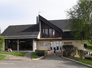
 Mairie Brognard |
||
Brognard is a French municipality with 481 inhabitants (as of January 1 2017) in Doubs in the region Bourgogne Franche-Comté .
geography
Brognard is 340 m above sea level, about six kilometers east-northeast of the city of Montbéliard (as the crow flies). The village extends in the northeast of the basin of Montbéliard, on a slightly elevated position above the broad valley floor at the confluence of the Savoureuse and Allan rivers .
The area of the 2.90 km² large municipal area includes a section of the gently undulating landscape in the area of the Burgundian Gate (Trouée de Belfort). The western part of the area is occupied by the approximately 1.5 km wide valley plain of the Savoureuse, which is on average 320 m. The municipality floor does not reach the river, but it includes several lakes ( Étangs de Brognard ), which were created by the filling of former sand and gravel pits and today serve as a water sports center and local recreation area of Montbéliard and Belfort. To the south, the community area extends into the Allan valley plain. The Canal de la Haute-Saône , which is connected to the Rhine-Rhône Canal, runs at the foot of the slope near Brognard .
From the valley level, the municipal ban extends northeast over an approximately 30 m high slope to the adjacent hills, which are divided by various hollows of side valleys of the Savoureuse. The area consists mainly of arable and meadow land. On the Les Épassottes corridor, Brognard's highest point is reached at 383 m.
Neighboring municipalities of Brognard are Dambenois in the north, Allenjoie in the east, Étupes in the south and Vieux-Charmont and Nommay in the west.
history
Since the Middle Ages Brognard belonged to the domain of the Counts of Montbéliard. With the annexation of the county of Württemberg-Mömpelgard (Montbéliard) , the village finally came into French hands in 1793.
population
| Population development | |
|---|---|
| year | Residents |
| 1962 | 228 |
| 1968 | 254 |
| 1975 | 228 |
| 1982 | 275 |
| 1990 | 424 |
| 1999 | 417 |
| 2004 | 433 |
| 2016 | 481 |
With 481 inhabitants (as of January 1, 2017) Brognard is one of the small communities in the Doubs department. After the population in the first half of the 20th century had always been in the range between 140 and 220 people, there has been significant population growth since the mid-1970s. Since then the number of inhabitants has doubled.
Economy and Infrastructure
Until well into the 20th century, Brognard was a village dominated by agriculture (arable farming, fruit growing and cattle breeding). In addition, there are now some local small businesses. In the meantime, the village has also turned into a residential community. Many employed people are therefore commuters who work in the agglomerations of Montbéliard and Belfort. The lakes in the Savoureuse Valley serve as a leisure, amusement and water sports park. A part is also designated as a nature reserve.
The village is well developed in terms of traffic. It is located on a departmental road that leads from Vieux-Charmont to Dambenois. The nearest connection to the A36 motorway , which crosses the municipality, is around one kilometer away. Another road connection is with Allenjoie.
