Area
| Area | ||
|---|---|---|

|
|
|
| region | Bourgogne-Franche-Comté | |
| Department | Doubs | |
| Arrondissement | Montbeliard | |
| Canton | Bavans | |
| Community association | Pays de Montbéliard agglomeration | |
| Coordinates | 47 ° 28 ' N , 6 ° 45' E | |
| height | 305-448 m | |
| surface | 3.11 km 2 | |
| Residents | 495 (January 1, 2017) | |
| Population density | 159 inhabitants / km 2 | |
| Post Code | 25420 | |
| INSEE code | 25054 | |
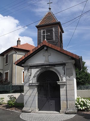
 Berche chapel |
||
Berche is a French municipality with 495 inhabitants (as of January 1 2017) in Doubs in the region Bourgogne Franche-Comté .
geography
Berche is located at 308 m , about six kilometers southwest of the city of Montbéliard (as the crow flies). The village extends on the southern edge of the Doubs valley across from Bavans, on the northern edge of the outermost mountain ranges of the Jura .
The area of the 3.11 km² large municipal area includes a section of the Doubstal. The northern border runs along the Doubs, which flows here with several bends in a flat valley low about one and a half kilometers wide and is accompanied by the waterway of the Rhine-Rhône Canal . From the course of the river, the community area extends southwards over the floodplain to the terrace of Berche, which consists of ice-age river deposits. To the south, a step of about 80 to 100 m in height leads over to the adjacent Tafeljura plateau . The height of Dampierre is partly covered by arable land and meadow, but also shows some larger forest areas ( Bois de Dampierre ). The highest point in Berche is reached here at 448 m. In the very south the area extends into the Les Combes valley system.
Neighboring communities of Berche are Bavans in the north, Voujeaucourt in the east, Mathay in the south and Dampierre-sur-le-Doubs in the west.
history
Berche is first mentioned in 1181. The place name goes back to the late Latin word barca , which refers to a ferry to cross the Doubs. In the Middle Ages, Berche belonged to the Dampierre rule, which had been under the suzerainty of the Lords of Neuchâtel since the 14th century . Together with Franche-Comté, the village came to France with the Peace of Nijmegen in 1678. Today Berche is part of the municipality association Pays de Montbéliard Agglomération .
Attractions
Among the sights of Berche are the Lavoir (1858) and the small chapel built in 1898. Berche belongs to the parish of Dampierre-sur-le-Doubs.
population
| Population development | |
|---|---|
| year | Residents |
| 1962 | 144 |
| 1968 | 184 |
| 1975 | 266 |
| 1982 | 367 |
| 1990 | 489 |
| 1999 | 428 |
| 2016 | 481 |
With 495 inhabitants (as of January 1, 2017) Berche is one of the small communities in the Doubs department. After the population in the first half of the 20th century had always been in the range between 90 and 120 people, there was significant population growth from 1960 to 1990.
Economy and Infrastructure
Until the 20th century, Berche was a village dominated by agriculture (arable farming, fruit growing and cattle breeding). In addition, there are now various local small businesses. In the meantime, the village has also turned into a residential community. Many workers are therefore commuters who do their work in the Montbéliard agglomeration.
The village is well developed in terms of traffic. It is located on a departmental road that leads from Colombier-Fontaine to Voujeaucourt. The closest connection to the A36 motorway is around five kilometers away.
literature
- Le Patrimoine des Communes du Doubs. Volume 2, Flohic Editions, Paris 2001, ISBN 2-84234-087-6 , pp. 913-914.
