Surmont
| Surmont | ||
|---|---|---|
|
|
||
| region | Bourgogne-Franche-Comté | |
| Department | Doubs | |
| Arrondissement | Montbeliard | |
| Canton | Bavans | |
| Community association | Pays de Sancey-Belleherbe | |
| Coordinates | 47 ° 17 ′ N , 6 ° 37 ′ E | |
| height | 600-793 m | |
| surface | 7.38 km 2 | |
| Residents | 121 (January 1, 2017) | |
| Population density | 16 inhabitants / km 2 | |
| Post Code | 25380 | |
| INSEE code | 25554 | |
Surmont is a French municipality with 121 inhabitants (as of January 1 2017) in Doubs in the region Bourgogne Franche-Comté .
geography
Surmont is located at 673 m , three kilometers southeast of Sancey-le-Grand and about 29 kilometers south-southwest of the city of Montbéliard (as the crow flies). The village extends in the Jura , on a high plateau that extends between the basin of Sancey (Vallon de Sancey) and the ridge of the Côte Noire.
The area of the 7.38 km² municipal area covers a section of the French Jura. The main part of the area is taken up by the high plateau of Surmont, which is on average 670 m. It is predominantly made up of arable and meadow land, but also shows some forest areas. The plateau is bounded in the west by the valley section of the Ruisseau de Voitre , in the northeast by that of the Ruisseau de la Baume . Both valleys are sunk around 100 m deep into the high plateau, with the border mostly running along the upper edge of the steep slope. In between is the northwestern protrusion of the Bois de l'Ouche . To the south, the community area extends over a stepped terrain up to the wide ridge of the Côte Noire , which separates the plateau from the Pierrefontaine basin. At 793 m, the highest point in Surmont is reached on the ridge.
Neighboring municipalities of Surmont are
- Sancey with Sancey-le-Grand and Sancey-le-Long in the north, Provenchère in the east, Belleherbe in the south and Laviron in the west.
history
In the Middle Ages Surmont was part of the Belvoir domain. Together with Franche-Comté , the village came to France with the Peace of Nijmegen in 1678.
Attractions
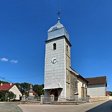
The village church of Sainte-Anne was built in 1848 on the site of a late medieval chapel.
population
| Population development | |
|---|---|
| year | Residents |
| 1962 | 138 |
| 1968 | 132 |
| 1975 | 121 |
| 1982 | 125 |
| 1990 | 128 |
| 1999 | 129 |
| 2016 | 124 |
With 121 inhabitants (as of January 1, 2017), Surmont is one of the smallest communities in the Doubs department. After the population had decreased significantly in the first half of the 20th century (238 people were counted in 1881), only minor fluctuations have been recorded since the beginning of the 1950s.
Economy and Infrastructure
Until well into the 20th century, Surmont was a village dominated by agriculture (arable farming, dairy farming and cattle breeding). In addition, there are now some local small businesses. Many workers are also commuters who work in the larger towns in the area.
The village is off the main thoroughfares on a departmental road that leads from Sancey-le-Grand to La Violette. Another road connection exists with Provenchère.

