
Sourans
| Sourans | ||
|---|---|---|
|
||
| region | Bourgogne-Franche-Comté | |
| Department | Doubs | |
| Arrondissement | Montbeliard | |
| Canton | Bavans | |
| Community association | Deux Vallées Vertes | |
| Coordinates | 47 ° 24 ' N , 6 ° 38' E | |
| height | 341-558 m | |
| surface | 4.20 km 2 | |
| Residents | 118 (January 1, 2017) | |
| Population density | 28 inhabitants / km 2 | |
| Post Code | 25250 | |
| INSEE code | 25552 | |

Sourans is a French municipality with 118 inhabitants (as of January 1 2017) in Doubs in the region Bourgogne Franche-Comté .
geography
Sourans is located at 370 m , about 17 kilometers southwest of the city of Montbéliard (as the crow flies). The village extends in the valley of the Ruisseau de Sourans south of the Doubstal and north of the Lomont range , in the extreme northern mountain ranges of the Jura .
The area of the 4.20 km² large municipality covers a section of the French Jura. The main part of the area is taken up by the valley of the Ruisseau de Sourans , which has a flat valley floor that is no more than 300 m wide. The stream drains the area north to the Ruisseau du Bié and thus to the Doubs. The valley is cut around 50 to 100 m into the surrounding heights, which form a tabular Jura-like plateau at the northern foot of the Lomont chain. At 558 m, the highest point in Sourans is reached at the edge of the high plateau near Goux-lès-Dambelin. The landscape shows a loose structure of arable and meadow land as well as forest areas.
The hamlet of Le Rochet ( 410 m ) at the height west of the Sourans valley belongs to Sourans. Neighboring municipalities of Sourans are Saint-Maurice-Colombier in the north, Goux-lès-Dambelin in the east, Hyémondans and Lanthenans in the south and Blussans in the west.
history
In the Middle Ages, Sourans belonged to the rule of Granges, which came under the sovereignty of the Counts of Montbéliard in the 14th century. Together with Franche-Comté , the village came to France with the Peace of Nijmegen in 1678. Today Sourans is part of the Deux Vallées Vertes municipal association .
Attractions
The Sourans Chapel was built in 1960.
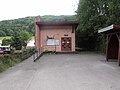
Mairie Sourans
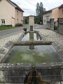
Fountain


population
| Population development | |
|---|---|
| year | Residents |
| 1962 | 88 |
| 1968 | 98 |
| 1975 | 113 |
| 1982 | 115 |
| 1990 | 119 |
| 1999 | 128 |
| 2004 | 121 |
| 2016 | 119 |
With 118 inhabitants (as of January 1, 2017), Sourans is one of the smallest municipalities in the Doubs department. After the population had decreased in the first half of the 20th century (142 people were still counted in 1886), a slight population growth has been recorded again since the beginning of the 1960s.
Economy and Infrastructure
Until well into the 20th century, Sourans was a village dominated by agriculture (arable farming, fruit growing and cattle breeding) and forestry. Even today, the residents live mainly from their work in the first sector. Outside the primary sector there are few jobs in the village. Some workers are also commuters who work in the surrounding larger towns.
The village is located off the major thoroughfares on a departmental road that leads from L'Isle-sur-le-Doubs to Hyémondans. The closest connection to the A36 motorway is around ten kilometers away. There are other road connections with Lanthenans and Goux-lès-Dambelin.