
Pont de Roide Vermondans
| Pont de Roide Vermondans | ||
|---|---|---|

|
|
|
| region | Bourgogne-Franche-Comté | |
| Department | Doubs | |
| Arrondissement | Montbeliard | |
| Canton | Valentigney | |
| Community association | Pays de Montbéliard agglomeration | |
| Coordinates | 47 ° 23 ' N , 6 ° 46' E | |
| height | 344-817 m | |
| surface | 13.58 km 2 | |
| Residents | 4,185 (January 1, 2017) | |
| Population density | 308 inhabitants / km 2 | |
| Post Code | 25150 | |
| INSEE code | 25463 | |
| Website | official page | |
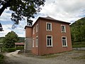
 Town Hall ( Hôtel de ville ) |
||

Pont-de-Roide-Vermondans is a French commune with 4185 inhabitants (as of January 1, 2017) in the Doubs department in the Bourgogne-Franche-Comté region . It belongs to the canton of Valentigney and was the capital of the canton of Pont-de-Roide, which existed until 2015 .
location
The municipality is located at the confluence of the Doubs , the Ranceuse and the Roide . The altitude is 360 meters. The town, 17 kilometers from Montbéliard and 24 kilometers from Maîche , is crossed by the D 437 and D 73 roads.
history
The lords of Neuchâtel ruled the area from around the 14th century . In 1388 the bridge over the Doubs was built on the spot where it is still today. The bridge, at the same time a border fortification to Switzerland, led to the development of a trading center. The salt trade in particular was carried out here; Up to around 1630, 70 to 80 truckloads per week made their way abroad.
In 1750 the bridge was rebuilt with six arcades and a tower over one of the arcades. In 1756 the parish church was rebuilt in the neo-Romanesque style. In 1790 the place became the canton capital. In 1842 the Lutheran Peugeot family settled in Pont-de-Roide and set up manufacturing facilities. In 1854, Jean-Frédéric Fritz Peugeot donated the property for the combined building of a Lutheran school and church. After the Franco-Prussian War of 1870/71, the place received a fortification, the Fort des Roches, in the face of German threat.
During the Second World War, the city was liberated on September 12, 1944. After that, a front is set up here to liberate the neighboring village of Vermondans. However, it was two months before Vermondans was taken by the Allies on November 15th.
The neighboring town of Vermondans was incorporated into Pont-de-Roide in 1972, before that it was an independent municipality with last 880 inhabitants (as of 1968). In December 2014, the community adopted the current double name Pont-de-Roide-Vermondans.
Population development
| year | 1962 | 1968 | 1975 | 1982 | 1990 | 1999 | 2007 | 2016 |
| Residents | 3744 | 4381 | 5342 | 4958 | 4983 | 4781 | 4619 | 4200 |
| Sources: Cassini and INSEE | ||||||||
Attractions
- Château Peugeot (now town hall)
- Château Herr (today the "du Château Herr" school)
- Catholic Church of the Nativity of the Virgin Mary ( Église de la Nativité-de-Notre-Dame )
- Lutheran Church from 1854
- Les Halles (now communal exhibition space)
- La Batterie des Roches (1877–1879)

Parish Church of the Birth of Mary

Parish church, interior view

Parish church crypt
Lutheran Church

modern church in the Vermondans district


Personalities
- Jules Joseph Bonnot (1876-1912), anarchist
literature
- Le Patrimoine des Communes du Doubs. Volume 2, Flohic Editions, Paris 2001, ISBN 2-84234-087-6 , pp. 935-939.
- Abbé Richard: Pont-de-Roide, Saint-Hippolyte et leurs environ . Le Livre d'Histoire, 2004, ISBN 2-87760-291-5 .
Web links
Individual evidence
- ↑ a b See "Pont de Roide: l'église luthérienne", on: Les temples ou églises luthériennes de France - [Recherche alphabétique: P], accessed on January 24, 2016.
- ↑ Pont-de-Roide - notice communale. In: cassini.ehess.fr. Retrieved January 5, 2016 (French).
- ↑ Décret n ° 2014-1447 du 3 décembre 2014 portant changement du nom de communes published in JORF and in Légifrance (French)