
Gémonval
| Gémonval | ||
|---|---|---|
|
||
| region | Bourgogne-Franche-Comté | |
| Department | Doubs | |
| Arrondissement | Montbeliard | |
| Canton | Bavans | |
| Community association | Deux Vallées Vertes | |
| Coordinates | 47 ° 32 ' N , 6 ° 35' E | |
| height | 305-513 m | |
| surface | 3.39 km 2 | |
| Residents | 85 (January 1, 2017) | |
| Population density | 25 inhabitants / km 2 | |
| Post Code | 25250 | |
| INSEE code | 25264 | |
 Town hall and school building |
||

Gémonval is a French commune with a population of 85 (as at 1st January 2017) in the Doubs department in the region of Bourgogne Franche-Comté .
geography
Gémonval is located at 379 m , ten kilometers north of L'Isle-sur-le-Doubs and about 16 kilometers west of the city of Montbéliard (as the crow flies). The village extends in the valley of the Scey in the hilly landscape north of the Doubstal , between the heights of Chanois in the west and Hautes-Roches in the east.
The area of the 3.39 km² municipal area comprises a section of the hilly landscape north of the Doube valley. The central part of the area is occupied by the valley basin of the Scey, which provides drainage to the northwest to the Ognon . This hollow is flanked in the west by the foothills of the Chanois (up to 430 m). To the east, the community area extends over an initially gently, then steeply rising slope, which is crowned at its upper edge by a ledge, to the limestone plateau of the Hautes-Roches . On this predominantly wooded high plateau, Gémonval's highest point is reached at 513 m.
Neighboring municipalities of Gémonval are Crevans-et-la-Chapelle-lès-Granges in the north, Saulnot and Arcey in the east, Onans and Marvelise in the south and Vellechevreux-et-Courbenans in the west.
history
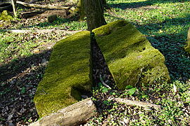
In the Middle Ages, Gémonval was part of the Granges rule, which came under the sovereignty of the Counts of Montbéliard in the 14th century. Together with Franche-Comté , the village came to France with the Peace of Nijmegen in 1678. Between 1826 and 1944 centuries, coal deposits were exploited here . Today Gémonval is part of the Deux Vallées Vertes municipal association .
Former coal mines

Elisabeth shaft.

De la Houillère shaft.

Essart's shaft.
Steam engine carrier from Schacht des Essarts.


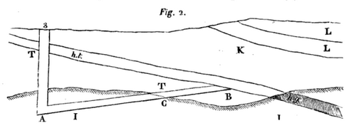
A sectional view of the shaft No. 3.
ht: "houille tendre" (coal),
hg (gray): "houille gypseuse" (coal).

population
| Population development | |
|---|---|
| year | Residents |
| 1962 | 76 |
| 1968 | 92 |
| 1975 | 75 |
| 1982 | 86 |
| 1990 | 100 |
| 1999 | 75 |
| 2005 | 88 |
| 2017 | 86 |
With 85 inhabitants (as of January 1, 2017) Gémonval is one of the smallest municipalities in the Doubs department. After the population had decreased significantly in the first half of the 20th century (180 people were still counted in 1881), various fluctuations have been recorded since the early 1960s.
Economy and Infrastructure
Gémonval was a village dominated by agriculture (arable farming, fruit and wine growing and animal husbandry) until well into the 20th century. In addition, there are now some local small businesses. In the meantime, the village has also turned into a residential community. Many workers are therefore commuters who work in the larger towns in the area.
The village is located off the major thoroughfares on a departmental road that leads from Longevelle-sur-Doubs to Crevans. The closest connection to the A36 motorway is around 19 kilometers away. Further road connections exist with Courbenans and La Chapelle.