
Exincourt
| Exincourt | ||
|---|---|---|

|
|
|
| region | Bourgogne-Franche-Comté | |
| Department | Doubs | |
| Arrondissement | Montbeliard | |
| Canton | Bethoncourt | |
| Community association | Pays de Montbéliard agglomeration | |
| Coordinates | 47 ° 30 ′ N , 6 ° 50 ′ E | |
| height | 317-382 m | |
| surface | 3.45 km 2 | |
| Residents | 3,222 (January 1, 2017) | |
| Population density | 934 inhabitants / km 2 | |
| Post Code | 25400 | |
| INSEE code | 25230 | |
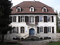
 Mairie Exincourt |
||

Exincourt is a French commune with 3,222 inhabitants (as of January 1 2017) in Doubs in the region Bourgogne Franche-Comté .
geography
Exincourt is located at 323 m , about three kilometers east of the city of Montbéliard (as the crow flies). The village extends in the basin of Montbéliard, on the southern edge of the wide valley of the Allan , at the northern foot of a hill that separates the valleys of Allan and Doubs .
The area of the 3.45 km² municipal area includes a section of the basin of Montbéliard on the southern edge of the Burgundian Gate (Trouée de Belfort). The northern part of the area is occupied by the almost two kilometers wide valley of the Allan, which is on average 320 m. The Allan river used to be the northern border. However, this was merged with the waterway of the Rhine-Rhône Canal and moved south, so that parts of the Peugeot area (Sochaux) north of the waterway and the motorway now belong to Exincourt.
To the south the terrain rises slightly to the Exincourt hill, which is around 340 to 350 m. It is divided into a western and an eastern part by the incision of a former tram. On a hill east of the village, Exincourt's highest point is reached at 382 m. With a 20 to a maximum of 30 m high steep slope this hill drops to the south to the wide valley plain of the Doubs at Audincourt. However, the community area does not extend to the river.
Neighboring municipalities of Exincourt are Sochaux in the north, Étupes in the east, Taillecourt and Audincourt in the south and Montbéliard in the west.
history
The first written mention of Exincourt was in 1150 under the name Assincurt . Since the Middle Ages, Exincourt belonged to the domain of the Counts of Montbéliard. The Reformation was introduced in the village from 1538. With the annexation of the county of Montbéliard , the village finally came into French hands in 1793.
In the 19th century, iron ore was mined at Exincourt and processed in the Audincourt ironworks. In the course of the 19th century, Exincourt developed into an industrial location. The traditional branches of industry included the watchmaking industry (until 1925) and the textile factory founded by the Japy industrial dynasty in 1893 (originally a cotton mill), which had to close in 1989. With the opening of the tram from Montbéliard to Hérimoncourt in 1904, Exincourt was connected to the public transport network (it was closed in 1932). The second half of the 20th century was characterized by the diversification of industry and the conversion of vacant factory areas. Today Exincourt is part of the Pays de Montbéliard Agglomération municipal association .

Notre-Dame chapel

Water tower
Château Sattler
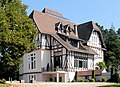
Château Sahler


Attractions
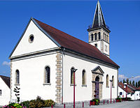
The Lutheran church ( Temple luthérien ) was built in 1846/1847 according to plans by Jean Frédéric Fallot in an elevated position above the village. The previous building, erected between 1738 and 1741, one of the twenty churches that were rebuilt or renovated on behalf of Duke Karl Eugen during his long reign, gave way to road expansion. The Château Sahler was built in 1903 as a villa for a family of industrialists and is now home to the Center interprofessionnel de promotion économique et sociale (CIPES).
- Lutheran Church in Exincourt


population
| Population development | |
|---|---|
| year | Residents |
| 1901 | 494 |
| 1926 | 1282 |
| 1954 | 2735 |
| 1962 | 3763 |
| 1968 | 4317 |
| 1975 | 4185 |
| 1982 | 3776 |
| 1990 | 3445 |
| 1999 | 3309 |
| 2005 | 3236 |
| 2005 | 3230 |
With 3222 inhabitants (as of January 1, 2017) Exincourt is one of the medium-sized municipalities in the Doubs department. After the population in the second half of the 19th century had always been in the range between 300 and 400 people, the population increased significantly from 1900 to 1930. Within these 30 years, the population quintupled. After a long period of stagnation, there was again significant population growth from 1950 to 1968. At the end of the 1960s, the highest level was reached with 4,317 inhabitants. The economic crisis and the restructuring of industry in the Pays de Montbéliard in the period from 1975 to 1990 led to a significant decline in population. The downward trend has continued to this day in a weakened form. Since the peak, Exincourt has lost about 1,100 residents, a decrease of 25%. Today the settlement area of Exincourt has grown together with those of Sochaux, Étupes, Taillecourt and Audincourt almost completely.
Economy and Infrastructure
Towards the end of the 19th century, Exincourt developed into an industrial community. Various industrial and commercial zones have been established since the 1970s. Large industrial areas are located in the Allan valley on both sides of the Rhine-Rhone Canal (part of the Peugeot area of Sochaux belongs to Exincourt) and in the Doubs valley. Today Exincourt offers more than 1000 jobs. The important branches of industry include automobile construction, micromechanics and metal processing. In addition, numerous companies that are active in the service sector have set up shop, such as trading and logistics companies, distribution centers, sales of medical-pharmaceutical articles and transport companies. There are also various large shopping centers, clothing and furniture factories, a hardware store and numerous retail shops for daily needs.
Exincourt is the location of the Center interprofessionnel de promotion économique et sociale (CIPES), a professional and educational center for adults in the Montbéliard-Belfort region.
The village is very well developed in terms of traffic. It is located on a departmental road that leads from Montbéliard to Étupes. The nearest connection to the A36 motorway , which crosses the municipality, is around one kilometer away. Further road connections exist with Sochaux, Audincourt and Taillecourt. Exincourt is connected to the city of Montbéliard and the surrounding communities by several bus routes.
Web links
Individual evidence
- ↑ a b See "Exincourt: le temple luthérien", on: Les temples ou églises luthériennes de France - [Recherche alphabétique: E] (section 'Historique'), accessed on January 23, 2016.
- ↑ Georges-Frédéric Goguel, Précis historique de la Réformation et des églises protestantes dans l'ancien comté de Montbéliard et ses dépendances , Paris: Marc-Aurel frères, 1841, p. 148.