
Goumois (Doubs)
| Goumois | ||
|---|---|---|

|
|
|
| region | Bourgogne-Franche-Comté | |
| Department | Doubs | |
| Arrondissement | Montbeliard | |
| Canton | Maîche | |
| Community association | Pays de Maîche | |
| Coordinates | 47 ° 16 ' N , 6 ° 57' E | |
| height | 485-953 m | |
| surface | 5.83 km 2 | |
| Residents | 162 (January 1, 2017) | |
| Population density | 28 inhabitants / km 2 | |
| Post Code | 25470 | |
| INSEE code | 25280 | |
| Website | www.goumois.com | |
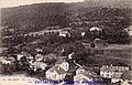
 View of Goumois from Switzerland |
||

Goumois is a French municipality with 162 inhabitants (as of January 1 2017) in Doubs in the region Bourgogne Franche-Comté .
geography
Goumois is located at 505 m , eleven kilometers east of Maîche and about 30 kilometers south-southeast of the city of Montbéliard (as the crow flies). The border village extends in the Jura , in the deeply cut Doubstal on the left (western) valley slope, opposite the Swiss village of Goumois (municipality of Saignelégier ).
The area of the 5.83 km² municipality covers a section of the French Jura. The eastern border always runs along the Doubs, which flows north through a canyon-like valley cut into the Jura plateau. At Goumois there is a small valley widening. Above and below the village, however, the steep valley slopes come together very closely and are criss-crossed by striking limestone bands in various places. From the course of the river, the community area extends westward over the predominantly wooded steep slope to the edge of the adjacent heights that separate the Doubstal from the Maîche plateau. At 953 m, the highest point of Goumois is reached at the Bois de Grépi near the Urtière plateau.
Goumois includes the hamlet of Gourgouton ( 661 m ) on a terrace on the western slope of the Doubs, as well as various groups of farms and individual farms. Neighboring communities of Goumois are Charmauvillers in the south, Urtière in the west, Fessevillers in the north and the Swiss community of Saignelégier in the east.
history
Goumois was first mentioned in 1177 under the name Gamoensis ecclesia , which was probably derived from the Germanic personal name Godemod . The village was under the priory of Lanthenans and in 1247 passed to the Counts of Montbéliard. Since the 14th century, Goumois belonged to the Franquemont rule (ruin on the territory of the Swiss Goumois), which was conquered by the Prince-Bishop of Basel in 1474, but was still disputed between the Prince-Bishopric of Basel and France until 1780 . From 1793 to 1815 Goumois belonged to France and was initially part of the Mont-Terrible department , from 1800 it was linked to the Haut-Rhin department . By the decision of the Congress of Vienna , the Goumois community was divided, with the Doubs forming the new border. The district to the left of the Doubs remained with France, while the district to the right of the Doubs came to the canton of Bern in 1815 and to the newly founded canton of Jura on January 1, 1979.
Attractions
The village church of Goumois was largely rebuilt in the 19th century, with some parts of the previous Gothic building being included. It contains, among other things, a wooden statue of the Blessed Virgin from the 15th century.
population
| Population development | |
|---|---|
| year | Residents |
| 1962 | 154 |
| 1968 | 148 |
| 1975 | 134 |
| 1982 | 126 |
| 1990 | 136 |
| 1999 | 196 |
| 2016 | 166 |
With 162 inhabitants (as of January 1, 2017) Goumois is one of the small communities in the Doubs department. After the population had decreased significantly in the first half of the 20th century (228 people were still counted in 1886), a significant increase in population has been recorded since the beginning of the 1980s.
Economy and Infrastructure
Goumois was a village dominated by agriculture (cattle breeding and dairy farming) and forestry until well into the 20th century. In addition, there are now some local small businesses and facilities for tourist needs. Many workers are also commuters who work in the surrounding larger towns.
In the meantime Goumois has developed into a destination in the Jura and is the location of a campsite. Leisure activities include, in particular, water sports (canoeing and kayaking), fishing and hiking.
The village is off the main thoroughfares on a departmental road that leads from Maîche to Saignelégier . Another road connection is with Trévillers .
Goumois, historical postcard

Goumois, historical postcard

Goumois, historical postcard

Goumois in the winter of 2008
_-TM-.jpg)
_-TM-.jpg)
_-TM-.jpg)
