Fontaine-lès-Clerval
| Fontaine-lès-Clerval | ||
|---|---|---|
|
|
||
| region | Bourgogne-Franche-Comté | |
| Department | Doubs | |
| Arrondissement | Montbeliard | |
| Canton | Bavans | |
| Community association | Deux Vallées Vertes | |
| Coordinates | 47 ° 26 ' N , 6 ° 28' E | |
| height | 320-462 m | |
| surface | 11.50 km 2 | |
| Residents | 299 (January 1, 2017) | |
| Population density | 26 inhabitants / km 2 | |
| Post Code | 25340 | |
| INSEE code | 25246 | |
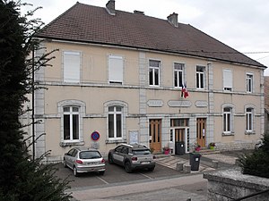
 Mairie Fontaine-lès-Clerval, former school |
||
Fontaine-lès-Clerval is a French municipality with 299 inhabitants (as of January 1 2017) in Doubs in the region Bourgogne Franche-Comté .
geography
Fontaine-lès-Clerval is located at 395 m , twelve kilometers northeast of Baume-les-Dames and about 26 kilometers west-southwest of the city of Montbéliard (as the crow flies). The village extends on the gently undulating limestone plateau between the river valleys of Doubs in the south and Ognon in the north, in a hollow on the edge of the Grand Bois.
The 11.50 km² municipal area covers a section of the undulating landscape between the Doubs and Ognon. The main part of the area is taken up by the arid high plateau, which is an average of 400 m. It is mostly made up of arable and meadow land, but also shows some larger forest areas. A dry valley begins at Fontaine-lès-Clerval and leads down to the Doubstal in several turns. The north-eastern part of the municipality is covered by the vast forest area of the Grand Bois , in which the highest point of Fontaine-lès-Clerval is reached at 462 m. The north-eastern demarcation runs above the steep drop to the valley section of the Ruisseau de Saye . There are no above-ground rivers in the entire area because the rainwater seeps into the karstified subsoil.
Neighboring municipalities of Fontaine-lès-Clerval are
- Soye in the north,
- Pompierre-sur-Doubs in the east,
- Pays de Clerval with Santoche and Clerval in the south,
- L'Hôpital-Saint-Lieffroy and Voillans also in the south,
- Viéthorey and Gondenans-Montby to the west.
history
Brick fragments point to a settlement in the municipality of Fontaine during the Gallo-Roman period. In the Middle Ages Fontaine belonged to Kastlanei Clerval, which came under the sovereignty of the Counts of Montbéliard in the 14th century. Together with Franche-Comté , the village finally came to France with the Peace of Nijmegen in 1678. To avoid confusion with other communities of the same name, Fontaine was officially renamed from Fontaine-lès-Clerval in 1961.
Attractions
A chapel built in 1596 was expanded in 1769 to become today's Church of Notre-Dame de la Nativité de la Sainte Vierge; the choir was renewed in 1825.
population
| Population development | |
|---|---|
| year | Residents |
| 1962 | 280 |
| 1968 | 288 |
| 1975 | 304 |
| 1982 | 301 |
| 1990 | 256 |
| 1999 | 242 |
| 2005 | 243 |
| 2016 | 292 |
With 299 inhabitants (as of January 1, 2017) Fontaine-lès-Clerval is one of the small communities in the Doubs department. After the population had decreased significantly in the first half of the 20th century (521 people were still counted in 1886), a further decrease began after a temporary stagnation in the mid-1980s.
Economy and Infrastructure
Until well into the 20th century, Fontaine-lès-Clerval was a village dominated by agriculture (arable farming, fruit growing and cattle breeding) and forestry. In addition, there are now some local small businesses. In the meantime, the village has also turned into a residential community. Many workers are therefore commuters who work in the larger towns in the area.
The village is off the major thoroughfares on a departmental road that leads from Rougemont to Clerval. The next connection to the A36 motorway , which affects the municipality, is about 14 kilometers away. Another road connection is with L'Hôpital-Saint-Lieffroy.


