Pompierre-sur-Doubs
| Pompierre-sur-Doubs | ||
|---|---|---|
|
|
||
| region | Bourgogne-Franche-Comté | |
| Department | Doubs | |
| Arrondissement | Montbeliard | |
| Canton | Bavans | |
| Community association | Deux Vallées Vertes | |
| Coordinates | 47 ° 25 ' N , 6 ° 31' E | |
| height | 275-393 m | |
| surface | 8.16 km 2 | |
| Residents | 307 (January 1, 2017) | |
| Population density | 38 inhabitants / km 2 | |
| Post Code | 25340 | |
| INSEE code | 25461 | |
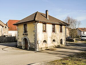
 Mairie Pompierre-sur-Doubs |
||
Pompierre-sur-Doubs is a French municipality with 307 inhabitants (as of January 1 2017) in Doubs in the region Bourgogne Franche-Comté .
geography
Pompierre-sur-Doubs is located at 283 m , about 22 kilometers west-southwest of the city of Montbéliard (as the crow flies). The village extends at the entrance of the Ruisseau de Soye into the lowlands of the Doubstal , on the northern edge of the extreme ridges of the Jura .
The area of the 8.16 km² municipal area includes a section of the Doubstal. The southern border runs along the Doubs, which flows here with several turns through a flat valley low about one kilometer wide and is accompanied by the waterway of the Rhine-Rhône Canal (two locks in the area of the village). From the course of the river, the municipal area extends northwards over the floodplain to the adjacent plateaus with the forest areas Bois du Frênoi , Bois de Theurey and Bois le Chanois . In between is the basin of the Ruisseau de Soye . At the northern edge of the municipality on the slope that leads to the limestone plateau north of the Doubs, the highest point of Pompierre-sur-Doubs is reached at 393 m.
Neighboring municipalities of Pompierre-sur-Doubs are
- Soye and Mancenans in the north,
- Rank in the east,
- Saint-Georges-Armont and Pays de Clerval with Clerval and Santoche in the south,
- Fontaine-lès-Clerval to the west.
history
During the Roman era, the traffic route from Vesontio (Besançon) to the Upper Rhine ran through the Pompierre area. In the Middle Ages, Pompierre belonged to the Clerval domain, which came under the sovereignty of the Counts of Montbéliard in the 14th century. Together with Franche-Comté , the village came to France with the Peace of Nijmegen in 1678. To avoid confusion with other communes of the same name, Pompierre was officially renamed Pompierre-sur-Doubs in 1923.
Attractions
The village church of Saint-Léger in Pompierre-sur-Doubs was built in the classical style in 1724 and extensively restored from 1821 to 1826.
population
| Population development | |
|---|---|
| year | Residents |
| 1962 | 319 |
| 1968 | 303 |
| 1975 | 311 |
| 1982 | 258 |
| 1990 | 244 |
| 1999 | 273 |
| 2006 | 312 |
| 2016 | 307 |
With 307 inhabitants (as of January 1, 2017) Pompierre-sur-Doubs is one of the small communities in the Doubs department. After the population had decreased significantly in the first half of the 20th century (449 people were still counted in 1886), population growth was recorded again until the turn of the millennium.
Economy and Infrastructure
Until well into the 20th century, Pompierre-sur-Doubs was mainly a village characterized by agriculture (arable farming, fruit growing and cattle breeding) and forestry. In addition, there are now a few local small businesses, mainly in the precision mechanics and tool making sectors. In the meantime, the village has also turned into a residential community. Many workers are therefore commuters who work in the larger towns in the area.
The village is located away from the larger thoroughfares. The main access is from Clerval on the main road N83 (Besançon-Montbéliard). The closest connection to the A36 motorway is around 15 kilometers away. Another road connection is with Soye. Pompierre-sur-Doubs has a station on the Dole – Besançon – Belfort railway line , but it is no longer served.

